


2. 中国石油化工股份有限公司石油勘探开发研究院, 北京 100083
2. Sinopec Petroleum Exploration and Production Research Institute, Beijing 100083, China
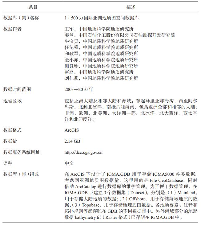
国际亚洲1:500万地质图(1:5M International Geological Map of Asia,缩写为IGMA5000)是根据世界地质图委员会(CGMW)决议,由中国地质调查局立项,中国地质科学院地质研究所组织实施,CGMW副主席任纪舜院士和CGMW主席Jean-Paul Cadet为总联系人的大型国际合作项目(Ren et al., 2013)。IGMA5000的立项起始于2002年CGMW巴黎会议决议,委托任纪舜院士(CGMW南亚和东亚分会负责人)提出亚洲1:500万地质图编图工作建议。2004年CGMW佛罗伦萨会议通过了任纪舜院士提出的建议。
IGMA5000由CGMW南亚和东亚分会负责,联合北欧亚分会、中东分会、海底图分会以及中国、法国、俄罗斯、哈萨克斯坦、蒙古、朝鲜、韩国、日本、伊拉克、伊朗、巴基斯坦、印度、缅甸、老挝、泰国、越南、柬埔寨、马来西亚、印度尼西亚、菲律宾等亚欧20个国家地质调查和研究单位130余名科学家在ArcGIS平台上,按国际标准共同编制第一份既表示大陆地质,又表示海底地质的资料最新的国际亚洲地质图。项目组历时8年时间最终完成了亚洲1:500万数字化地质图和空间数据库的建库工作。
IGMA5000在亚洲地质科学研究史上具有里程碑意义,取得了诸多重要成果和进展(Ren et al., 2013)。它是目前第一幅全面反映亚洲大陆及相邻海域的地质图件;是第一份在统一思想指导下,按统一标准和规范以国际标准为依据编制而成;是第一份建有空间数据库的亚洲地质图,为实现数字亚洲地质迈出了坚实的一步;是目前资料较新、较全的国际亚洲地质图;IGMA5000是编图与专题研究相结合,共同进行完成的(任纪舜等, 2013)。
IGMA5000的编图范围包括亚洲大陆及相邻大陆和海域。东起马里亚那海沟,西至阿尔卑斯,北到北冰洋,南抵爪哇海沟,包括亚洲全部和相邻的大陆,非洲、欧洲、北美洲、大洋洲一部,北冰洋、北大西洋、西太平洋和北印度洋(图 1)。

|
图 1 亚洲1:500万地质图编图范围 |
亚洲1:500万地质图空间数据库的元数据简介如表 1所示。
|
|
表 1 数据库(集)元数据简表 |
IGMA5000是建立在GIS基础之上的数字化地质图,数据库是IGMA5000成果的一个重要组成部分。考虑到软件的通用性,IGMA5000选择ArcGIS作为地质图编制及数据库建设平台。ArcMap作为数据的编辑和显示平台,ArcCatalog作为数据库管理平台,ArcToolbox提供了很多实用功能可以用于亚洲地质图的数据编辑和整理,ArcGIS的一些扩展功能如Maplex、Spatial Analyst等也可满足亚洲地质图在图面可视化和后期应用等方面的需要。IGMA5000先后使用了ArcGIS9.1、9.2、9.3和10.0多个版本,ArcGIS在数据库和制图方面的新技术不断地用于IGMA5000的编制中。
IGMA5000数据库在设计过程中遵循以下原则:(1)标准化,数据库各属性项地质内容中使用的术语采用国际通用术语,并建立IGMA5000专用术语词典库,对不能采用术语表述的的地质属性内容,制定了详细的属性内容的填写规范;(2)采用ArcGIS的Geodatabase(GDB)存储、管理数据,通过使用Geodatabase特有的属性域(Domain)、子类(Subtype)和拓扑规则(Topology),保证空间数据和属性数据的自洽性和一致性;(3)数据库的设计合理,在ArcMap下通过制定制图规范、制图规则、标注规则、设计1:500万亚洲地质图专用Style库、使用Representation技术等,以数据驱动制图的工作模式,提供了高度自动化的制图。
3 数据库结构 3.1 数据模型IGMA5000数据库设计经历了概念模型—逻辑模型—物理模型三个阶段(Zeiler,2010),期间根据各国地质学家讨论,编图细则和图例不断修改补充,数据库的设计也随之不断调整完善。
首先课题组对IGMA5000编图细则和图例进行了深入研究,充分理解了编图思想,在此基础上提出了“IGMA5000数据库的概念模型(图 2)。在概念模型的基础上,利用Microsoft Viso软件,用统一建模语言(UML)设计了数据库的逻辑模型。在上述概念模型和逻辑模型的基础上,在ArcGIS平台下设计了基于Geodatabase(GDB)的IGMA5000数据库。

|
图 2 1:500万国际亚洲地质图数据模型 |
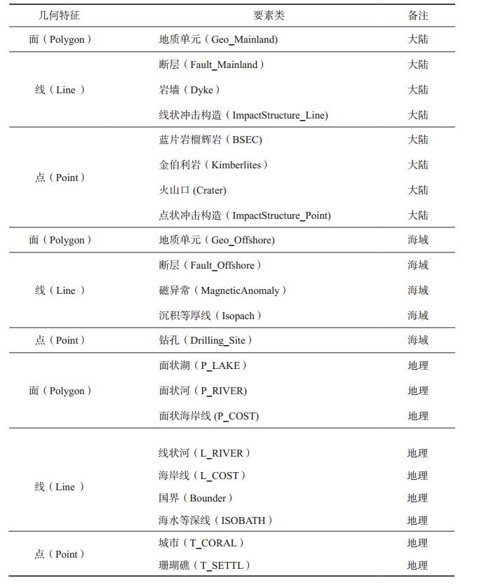
IGMA5000是建立在GIS基础上的基于数据库的数字地质图。既表示大陆地质内容,同时也表示海域地质。图面地质内容包括地层、岩浆岩、火山岩、蛇绿岩、变质岩和特殊岩类(如金伯利岩、榴辉岩、蓝闪石片岩等具有特殊地质意义的岩石)以及第四纪特殊成因类型(沙漠、黄土等)、断层、火山口和冲击构造等;在海域部分,表示了洋壳、增生杂岩、磁异常条带、扩张轴断裂和具有代表性的钻孔,其中边缘海还增加了新生界沉积等厚线等地质内容。不同类型的地质实体根据其自身特点分别用点、线、面等要素表示。各图元要素之间通过拓扑建立空间关系,通过坐标系统和真实世界建立联系,通过关系数据库(属性库)反映地质体的各种特征。表 2归纳了IGMA5000涉及的各类地质要素。在ArcGIS下设计了IGMA.GDB(File GeoDatabase),同时借助ArcCatalog进行数据库的维护管理。为了便于数据管理,在IGMA.GDB下建立3个数据集(Dataset),分别是:(1) Mainland,用于存储大陆地质的数据;(2) Offshore,用于存储海域地质的数据;(3) Topobase,用于存储地理底图数据。各地质要素、注释和拓扑规则等都存贮在GDB的不同数据集中。另外海域部分的地形数据bathymetry.tif(Raster格式)已存储在IGMA.GDB中。数据库数据储存管理系统如图 3所示。
|
|
表 2 “亚洲1:500万地质图”涉及的各类地质要素 |

|
图 3 “1:500万亚洲地质图”GeoDatabse数据库 |
“1:500万国际亚洲地质图”采用如下的投影参数:
椭球体:Spheroid: WGS-84
地图投影:等面积斜方位投影(Lambert_Azimuthal_Equal_Area)
投影中心:λE90°,ϕN40°
3.3 数据标准IGMA5000制定数据规范主要参考了世界地质图委员会的下属DIMAS委员会制定的小比例尺数字地质图标准❶,1:500万欧洲及邻区地质图❷、北美的NGMDB ❸、国际地科联的CGI等相关标准❹等,IGMA5000数据库各要素的地质属性,如地质年代、岩石名称、断层类型名称、沉积相、第四纪成因类、特殊岩石组合和变质级别等尽量采用广泛接受的地质科学的研究成果和国际通用标准为基本原则,建立起国际亚洲1:500万地质图的属性数据词典。凡是能通过词条能进行表述的,一律采用词条的方式表达。不能以词条形式表达的编制了统一的填写规范要求,以达到表达方式的规范化。
3.4 属性结构根据IGMA5000编图细则,设计了各要素的属性结构。大陆地质面元是图件最主要的一个空间要素,表 3按字段名称、属性项的说明、数据类型、长度和约束条件,列出了亚洲地质图大陆地质面元属性结构。总体来说属性项的设置按其不同的功能可以分为3类:标识属性、地质属性、参数属性。
|
|
表 3 大陆地质面元(Geo_Mainland)属性表结构 |
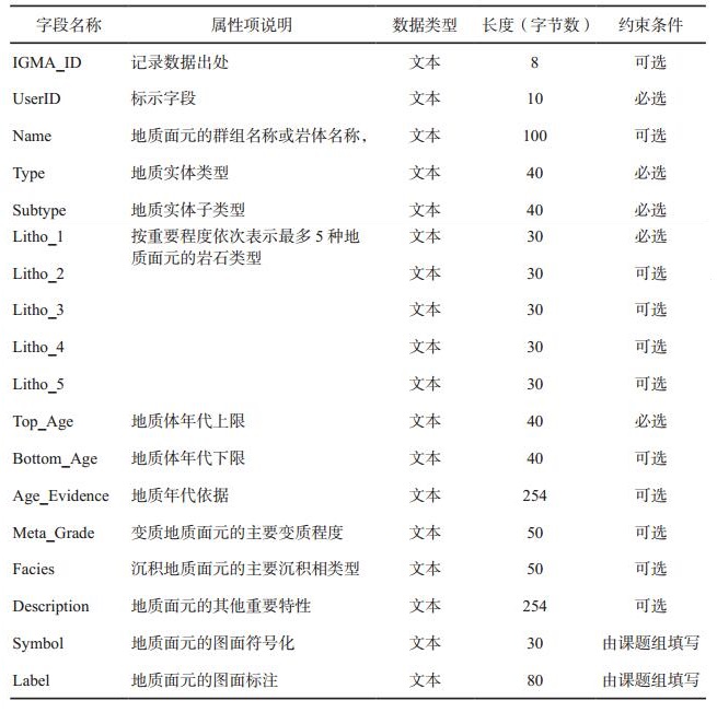
(1) 标识属性,如“IGMA_ID”用于记录数据的出处;“UserID”项是主要的标示字段,也用来建立图与库之间的对应关系。
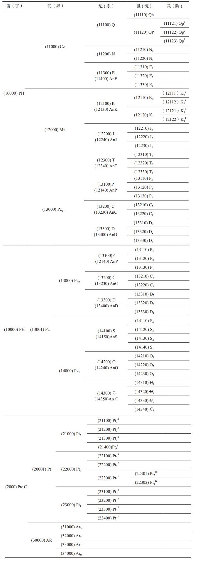
(2) 地质属性,其中“Type”和“Subtype”用来表示不同的地质实体;“Name”用来表示地质面元的群组名称或岩体名称。“Top_Age”和“Bottom_Age”分别用来表示地质体年代的上限与下限,不是跨纪的地质面元只用“Top_Age”表示,根据国际地层表(2004, 2008, 2010),并在项目综合组对亚洲前寒武纪对比基础上提出的前寒武纪地层划分方案,制定“1:500万亚洲地质图”标准年代代码(表 4),为后期开发按不同年代进行检索查询提供了方便。“Age_Evidence”用来表示地质年代依据。“Litho1”至“Litho3”按重要程度依次用来表示地质面元的主要岩石类型。“Litho4”和“Litho5”用来表示地质面元次要或其他特殊的岩石类型。“Facies”用来表示沉积地质面元的主要沉积相类型。“Meta_Grade”用来表示变质地质面元的主要变质程度。“Description”用来表示地质面元的一些其他重要特性。
|
|
表 4 1:500万亚洲地质图年代符号及代码 |
(3) 参数属性包括填充参数“Symbol”和标注参数“Label”,前者用于图面符号化。后者用于图面标注。这两项与制图有关的属性是由本课题组来填写的,是根据前面的地质属性,按照编图细则和图例,编制相应程序自动生成。
4 数据整理集成IGMA5000具有编图范围广、参与方众多、数据量庞大、各方提供的数据格式多样等特点,是典型的多源异构数据的整合。
4.1 数据IGMA5000数据源众多,主要包括:(1)各工作组提供的数据;(2)项目组收集的亚洲有关地区最新的地质图件;(3)项目组收集的亚洲周边1:500万欧洲及邻区地质图(纸质)、1:500万北极地质图(PDF)、1:500万地质图数据库(ArcGIS格式)、1:500万澳大利亚地质图(纸质)、1:500万非洲地质图(纸质)、1:2000万世界地质图(纸质)及印度洋构造图(AI格式)等数据。
4.2 数据集成与图形拼接尽管1:500万国际亚洲地质图制定了编图规范和统一的数据结构,但是各方提供的地质数据出于各种原因存在着较大的差异,主要有如下几点:
(1) 除少数数据外,基本上使用各自的编图规则,图面表达的地质要素各有不同,未使用统一的图例;
(2) 地质年代的划分未统一到国际地层表上,如寒武纪存在三分和两分的情况;亚洲各国前寒武纪的地层划分对比方案还需进一步完善;部分数据地质单位划分到阶,而不是国际亚洲地质规定的统;
(3) 火成岩的分类存着差异;
(4) 各方数据采用各自的投影;
(5) 编制软件不同,主要涉及到的软件包括ArcGIS、MapGIS、MapInfo、AutoCAD、TNT等,还有较多数据是纸质地质图,需进行矢量化处理;
(6) 图层不同,国际亚洲地质图规定地质面元、断层系统(线要素)和特殊岩石(点要素)、火山口(点要素)、钻孔(点要素)等几层数据,而各方提供的数据或多或缺少;
(7) 数据结构不同,国际亚洲地质制定了统一的数据结构,但各方提供的数据均存在数据结构的差异;
(8) 数据质量不同,如俄罗斯提供的数据质量非常好,但其他国家提供的数据存在大量拓扑错误;
(9) 各方数据还存在着编图范围重叠的问题;
(10)与地理底图不套合,未按统一的地理底图开展编图;
(11)接边问题。
为了得到一张统一完整的国际亚洲地质图,项目综合组必须对各方提交的数据按”亚洲1:500万地质图”的规范进行标准化处理加工,除地质上的统一处理外,针对数据还要进行以下的处理加工:
(1) 统一数据格式。将不同软件编制的地质图转换到ArcGIS平台下,以File GeoDatabase的形式存储;
(2) 统一图层。将有关图层或合并或剔除;
(3) 统一数据结构。为了便于数据库的应用系统的开发,必须将各方数据按统一的数据结构进行处理;
(4) 统一投影方式。国际亚洲地质图数据量大,如各方使用各自的投影,则在ArcGIS环境下,动态投影转换费时较多,影像数据的使用,故需将各方数据转换为统一的投影是十分必要的;
(5) 统一的数据质量。主要是包括修复几何错误(Repair Geometry)和纠正数据中存在的拓扑错误,特别是面元的重叠(Overlay)和间隙(Gap)错误以及线元的交叉、重叠等;
(6) 统一地质体表现形式。据地质属性填写标准的“Symbol”和“Label”项。
多数数据处理可总结为图 4所示的流程,首先将不同格式的数据转换为ArcGIS的Shapefile;在进行这步处理时如果数据超出了其应占有的范围应对数据进行裁剪;接下来进行投影转换;投影转换完成后在ArcGIS下修复几何错误,然后将数据导入不同的GeoDatabase(GDB)中;在GDB中创建数据集(DataSet)并在数据集中建立拓扑规则;接下来对数据进行拓扑检查和修复拓扑错误;在修改完成数据错误后根据各方数据的特点,编制不同的转换程序对重要属性项按国际亚洲图的规范进行转换,这部分工作大多是在ArcGIS环境下,采用Map Calculation方法处理的;接下来在属性表中创建“Symbol”和“Label”两个属性项,根据地质年代和岩性等关键属性,按统一的规则计算生成这两项的值,其中“Symbol”项用于与Style库匹配,实现图面的符号化,“Label”用于生成图面标注。

|
图 4 部分数据加工处理流程 |
考虑到国际亚洲地质图数据量大,数据处理耗时耗力,因此在数据处理过程中,尽量采用利用ArcGIS本身的一些功能,加以编制相应的程序,提高数据处理的自动化程度,从而提高工作效率。因此针对不同数据的特点在ArcGIS Catalog下开发了不同数据处理模块(Model)自动完成相应的数据处理。
4.3 数据检查与数据质量在ArcGIS下主要通过域(Domain)、子类对地质属性进行检查和质量控制。通过拓扑规则对空间数据进行检查。
根据亚洲图的特点,对地质面元主要制定了两类拓扑规则,即“Not have gaps”和“Not overlay”。对线元数据主要是断层数据制定了“Must Not Overlap”, “Must Not Intersect”,“Must Not Self-Overlap”, “Must Not Self-Intersect”等规则,并利用ArcMap中的拓扑检查工具对数据进行了拓扑检查与修正。
ArcGIS是在数据集Dataset下建立拓扑规则的。为了便于数据管理,将亚洲地质图数据分别存放在MainLand和Offshore两个数据集中,这两个数据集中的数据,如地质面元也存在空间关系,需要进行拓扑检查。MainLand和Offshore两个数据集中的数据是按地理底图中的海岸线划分的,因此在数据整理编辑过程中,是以海岸线作为公共边界的,以此可以实现大陆地质和海域地质数据保持正确完好的空间关系。
关于属性正确性,主要是通过域来控制的。最终数据也考虑利用ArcGIS的Data Review扩展模块再进行一次检查,以保障输入属性的正确性。
5 基于数据库ArcGIS制图在数据的集成处理后,得到的是按照一定规则组织起来的具有空间位置的矢量数据,对这些数据还需进行图面可视化处理,才能得到一张根据一定规则用不同颜色、花纹、线型、符号等来表现不同类型地质体的地质图。开展这项工作的一个重要依据是根据图例制定可视化方案。图例不仅是编图地质思想的高度集中体现,同时也是制图学方面如何清晰准确而又艺术美观地在图面上反应各种地质内容的一个缩影。IGMA5000在2005年召开的第一次国际工作会议上就推出了项目组制定的图例,以后这一图例不断修改完善。
地质图可视化处理主要分为两个部分,一是图元的符号化处理,二是图面标注。项目组引入“属性驱动制图”的先进理念,摸索出一套ArcGIS环境下地质图可视化处理的行之有效方法。
5.1 图面符号化处理 5.1.1 用Symbol项实现图面快速符号化在ArcGIS平台下,根据图例建立了IGMA5000专用的图例库(Style库)(图 5),包括各种图面填充、颜色方案、线型、点符号等。IGMA5000 Style库中共建立了783个图案花纹,38个线型和10个子图符号Style。在Style库中为了便于管理不同的地质图案放入不同的目录下,库中的每一个图案都有一个标准的名称,如二叠系地层用“P”表示,二叠纪花岗岩用“γP”表示,二叠纪基性火山岩用“βP”表示。

|
图 5 “亚洲1:500万地质图”ArcGIS下设计的Style库部分内容 |
各类图元通过属性字段中设计的“Symbol”一项与Style库建立关联,在ArcGIS平台下,将采用“match to symbol in a style”的方式进行匹配(图 6),从而快速实行不同地质体的图面表达。属性库中的“Symbol”一项是根据属性库中地质属性,如地质年代和岩石类型、沉积环境以及变质程度等地质内容,按编图细则和图例来确定的,symbol项在库中依据规则编制了相应程序,可根据属性库中的其他地质属性内容自动生成。

|
图 6 ArcGIS环境下用属性项匹配的方法实现图元符号化 |
这一方法可以快速的实现空间数据的符号化处理,与传统方法相比有着巨大的优势。特别是在编图过程中,由于各种原因图例方案经常会修改,色标和花纹也会随着不断变化。图例修改后只需修改对应的图例库(Style库)的内容,而属性库中“Symbol”项是根据各种地质内容生成的不会随色标和花纹的改变而改变,这样不需要改变数据本身,只需重新匹配一下就可以实现图面的符号化,大大提高了数据处理的效率,起到了属性驱动制图效果。特别在编图后期,颜色方案和花纹方案调试中有着较强的优势。
5.1.2 Representation提高图面符号化质量自ArcGIS 9.2版本以来,ArcGIS开发了一套灵活的基于规则的高级智能化制图表达机制—Representation,Representation作为要素类的属性存储于GDB中,可以使用基于规则的结构对数据进行符号化,可以在多用户的环境和空间数据迁移的过程中共享和重用制图方案。还可以采用Free Representation对符号化的局部要素进行灵活地修改。特别指出的是ArcGIS制图表达多数情况下是与图元的属性密切相关的,基于属性的某些字段,利用设置一定的规则来实现图面的表达,而且图面表达通常与数据存储在同一个GDB中,属性字段改变,相应的图面表达也发生变化,从而实现属性驱动制图。
为了使图面更加美观,IGMA5000编制中使用了Representation技术对图面表达进行进一步优化。下面仅举几例说明。
(1) 对图面花纹的调整
按统一规则制定的花纹,由于地质面元形状的不规则性或因其面积过小,有时候绝大多数面元的填充效果是可以的,但个别面元并不理想。这种情况下,可以选中该面元,利用Representation工具中的“Resize”、“Move”等工具进行调整。
(2) 对逆冲断层箭头的调整
在地质图上逆冲断层通常采用线段加箭头的方式表示。在ArcGIS中,可以通过线形制作工具创建这种线形。并且在大多数情况下,可以在图面较好地显示逆冲断层,但是个别情况下,如线段存在较陡弯曲时,会出现箭头与线段分离的情况。针对这种情况可以利用Representation相关技术进行调整。
首先将图面表达转化为Representation,然后调整表达规则。在符号位置(Maker Placement)中选择在节点上(On vertices),并进一步选择在控制点上(On control point)和与线段垂直(Angle to line),同时设置箭头符号适当的偏离(offset)值,然后应用Representation规则,接下来在图面上只要对需要位置添加控制点就可以出现逆冲断层的箭头,用这种方法可以比较完好的在图面显示逆冲断层。
上述几个简单例子,可以看出ArcGIS的制图表达是非常丰富的,完全可以满足地质图的制图要求。
5.2 图面标注图面可视化的另一个重要内容是图面标注。IGMA5000数据量大,数据在不断补充修改,因此在编图过程中找到一种快速生成图面标注供地质人员进行图面检查是非常必要的。
为此在属性库中设计了“Label”项用做图面标注对应的属性项。“Label”项是通过属性库中地质年代、岩石类型、沉积类型等相关内容按一定规则经计算得到的。图面标注的一般流程是:(1)计算得到“Label”值;(2)用“Label”字段进行标注;(3)将标注转为注释(Annotation)并存入GDB中;(4)后期进一步调整。
在用“Label”字段进行标注,利用ArcGIS的分级标注功能,将标注分为3种情况(图 7):(1)正常标注(Normal Label)用于面积大小满足标注要求的地质图,此类标注取面元的质心;(2)引线标注(with a leader line)用于对图面面积较小无法容纳标注内容且重要的地质体,此类标注程序自动生成引线,这样不仅提高了地质图的可读性,也节省了大量的人力和时间;(3)不标注(no label),主要用于图面面积小且不重要的地质体。

|
图 7 地质注记(符号)按地质体分级标注 |
ArcGIS的“Labeling”工具集用于图面标注的管理,除控制标注的位置、字体、大小、颜色外,还可以控制不同要素层的标注级别,将主要要素赋予较高的权重,这样可以保证使主要要素在正确的位置上实现标注,而次要的要素则自动避让。标注时还充分利用ArcGIS自带的Maplex扩展功能,强化图面标注的功能,使标注更人性化,简化了后期的编辑工作。Maplex扩展模块主要包括3个方面的功能:(1)控制标注的位置。可以选择水平标注、与要素方向平行标注、弯曲标注等。Maplex扩展模块可以控制标注的偏离量。地质图中常使用的按纬线方向标注也可以在此实现。Maplex扩展模块还为特殊的要素如等高线、河流等设计了专用标注的解决方案。对于点要素可以方便地选择12点的位置,并控制标注旋转的角度。(2)自动标注调整规则。主要包括是否允许换行标注、是否允许跨要素标注、自动减小标注字体、自动裁剪标注字段和控制不标注要素的大小等。(3)冲突控制。主要包括分别设置内部标注和跨要素标注的权重、背景标注优先、一定范围内避免重复标注和标注的缓冲等。
为了提升显示速度,将标注转为注释(Annotation),存储在数据库中。这样动态的Label标注就转化相对静态的注释(Annotation),大大提升了地质图的显示速度。与此同时注释在数据库中与属性表中的“Label”项保持着关联关系,但地质体相关地质属性修改后,“Label”属性项也随之修改,图面标注也随之更新。
上述标注应用只是在编图过程中为了提高工作效率而采用一种方法,程序按照各种规则综合判断产生的标注与人为确定的最佳位置还是有差别的,在图面定稿后应在对程序自动生成的标注进一步进行人工干预的修改调整,上述自动标注为最终人工调整奠定了良好的基础,大大降低了工作量。
同时,对不同的图元还采用了ArcGIS其他标注功能提高图面的美观性。如山脉、河流采用按曲线标注,等深线采用ArcGIS特有的等高线标注方法。
任何GIS软件得到自动标注都不能完全满足出版要求,ArcGIS也不例外。程序只是按规则对标注进行筛选定位,由于地质图的复杂性,在图面某一范围内合适的参数很可能不适合其他范围,经过反复调试只能得到一个相当满意的结果,后期人工参与调整是必要可少的。ArcGIS的Annotation工具栏用于图面注释的调整,借助此工具栏可以调正注释位置;调整注释的字体、大小、颜色、字间距等、调整注释按曲线排列、查看关闭的注释、调整注释的打开/隐藏等。在标注调整过程中,可以对某一要素的注释统一修改,如统改字号大小;也可以对个别要素单独调整。这里值得一提的是,在ArcGIS下生成的注释是存贮在GDB中的,是与原数据之间有着关联的,如果修改原数据标注项的值,图面注释也会得到相应的改变,这一点极大方便了后期的数据的修改。比如某一地质面元,原来认为是下三叠统(T1)的,在属性字段“Label”的值是“T1”,后期检查将“Label”值改为“T1-2”,此时图面的标注会自动更改为“T1-2”。
经过上述图面符号化和标注的操作,最终生成了ArcGIS版的1:500万国际亚洲地质图(图 8)。

|
图 8 最终ArcGIS版的1:500万国际亚洲地质图 |
IGMA5000空间数据库的内容与结构设计,是根据项目组编制的《1:500万国际亚洲地质图编图细则》的要求,遵循GeoDatabase的设计原则,结合亚洲地质图的特点完成的。数据按基础地理、陆域地质、海域地质与海域地形影像四个数据集组成,包括地质体、断层、钻孔、冲积构造、新生代火山口等13个要素类及其相应的属性表与代码表。数据库的设计通过了国际亚洲1:500万地质图国际工作会议的审查,是数据库建设的指导文件。
数据库的基础地理数据来源于项目底图编制组提供的1:500万地理底图数据,该数据是根据测绘局提供的亚洲及邻区1:100万地形图数据缩编而成,并经项目的国际工作会议讨论、修改与确认,数据权威可靠,满足编图要求。
用于建立1:500万国际亚洲地质图数据库的原始数据由20多个参与国提供,数据的结构、格式、内容详略程度与数据质量差别较大,具有典型的多源异构特征。项目组确定了适用于图面表达的统一坐标参照系,对不同结构的数据进行整合;针对部分地区属性细节内容缺失的数据,项目组通过各种渠道,多方搜集数据进行补充,形成了统一的可以满足编图需要的数据库。基于该数据库编制的1:500万国际亚洲地质图于2012年4月通过了国际地质图编图委员会(CGMW)的审查,获得高度评价即为很好的证明。
7 结论1:500万国际亚洲地质图空间数据库遵循统一的编图细则和图例,按照数据库设计的基本原则,借鉴国内外小比例尺数字地质图编制的新技术,在各工作组提供的数据基础上,建立ArcGIS平台下的地质图数据库,汇总、编辑、整合多源异构数据,研究开发ArcGIS平台下基于数据库的地质图编制方法,快速实现ArcGIS平台下的地质图编制。它是第一幅全面反映亚洲大陆及相邻海域地质的IGMA5000;第一幅按CGMW和IUGS国际标准编制的IGMA5000;第一幅在ArcGIS平台上建有空间数据库的,并采用计算机辅助编图方法编制的IGMA5000。编图与专题研究相结合,是IGMA5000的最大特色。通过专题研究,取得了一系列新发现和新进展,并把最新研究成果应用于编图。
1:500万国际亚洲地质图数据库中一些国家提供的数据还存在属性内容不完善的问题,同时项目后期地质图数据做了一些修改,个别修改还未及时更新到库中,希望后续项目能对1:500万国际亚洲地质图数据库继续补充完善。
致谢: IGMA5000数据库建设得到了各参与国地学家的大力支持,得到了世界地质图委员会原主席Jean-Paul Cadet, 原秘书长Philippe Rossi,Manuel Pubellier和世界地质图委员会下属小比例尺数字地质图标准分会(DIMAS)K. Asch博士等的支持和指导;IGMA5000数据库建设中方参与人员包括张庆合、陈克强、姚冬生、张二朋、杨明桂、王友勤、曾勇、雷桂侠、张艳玲、邓平等专家;数据库建设得到了ESRI中国公司李策、康来成、陈俊、王坚,武汉地大信息工程有限公司马维峰等的有益指导意见,在此一并表示感谢。
注释:
❶ K. Asch, J. Broome, I. Jackson, D. Janjou, M. Pubellier, D. Soller, R. Tomas, K. Wakita & J. Wang,Specification guidelines for geological maps, geographic information systems and database,DIMAS, 2007.website: http://www.geology.cz/dimas/relatedlinks.
❷ Asch C. & al. (N. Chamot-Rooke & M. Pubellier), 2004. IGME 5000 : International Geological Map of Europe and Adjacent Areas, IGME – Commission for the Geological Map of the World (CGMW), 2 sheets : 167x127 cm, 1:5.000.000 scale.
❸ National Geologic Map Database,Standards and Guidelines,Website: https://ngmdb.usgs.gov/Info/standards.
❹ CGI Data Model Collaboration, Website: https://www.seegrid.csiro.au/wiki/CGIModel/WebHome.
1 IntroductionThe 1:5000000 International Geological Map of Asia (IGMA5000) is an international cooperative project approved by the Chinese Geological Survey (CGS) and implemented by the Institute of Geology, Chinese Academy of Geological Sciences, according to the resolution of the Commission for the Geological Map of the World (CGMW). President Jean-Paul Cadnet and Vice-President Ren Ji-shun of CGMW are the General Coordinators of this project. CGMA5000 was initiated by the resolution of the CGMW Paris Conference 2002, which entrusted Prof. Ren Ji-shun (President of the Subcommission of South and East Asia of CGMW) to put forward a work proposal for IGMA5000. Prof. Ren Ji-shun’s proposal was approved by the CGMW Florence Conference in 2004.
IGMA5000 is jointly compiled on the ArcGIS platform in accordance with international standards by over 130 scientists from four subcommissions of CGMW (the Subcommission of South and East Asia, the Subcommission of North Europe and Asia, the Subcommission of the Middle East and the Subcommission of Submarine Maps) and 20 geological surveys and institutes of European and Asian countries, namely, China, France, Russia, Kazakhstan, Mongolia, North Korea, South Korea, Japan, Iraq, Iran, Pakistan, India, Burma, Laos, Thailand, Vietnam, Malaysia, Indonesia and the Philippines. The Subcommission of South and East Asia of CGMW is in charge of the project. IGMA5000 is the first up-to-date international geological map of Asia displaying both offshore and onshore geological data. After eight years of effort, the project team fnally completed the compilation of the digital 1:5000000 International Geological Map of Asia and the construction of the spatial database.
IGMA5000, achieving a variety of important results and developments, is a milestone in the history of Asian geological research. It is the frst geological map of Asia that fully reflects both the Asian mainland and adjacent oceans; the first Asian geological map of Asia that is compiled under uniform guidance in accordance with uniform international standards and specifications; the first digital geological map of Asia that has a spatial database, and it has taken a solid step forward for the realization of digital Asian geology. IGMA5000 is compiled with the most up-to-date and complete data in the world, in combination with thematic researches (Ren Jishun, et al., 2013).
IGMA5000 covers the Asian mainland and the adjacent oceans from the Mariana Trench in the east to the Alps in the west (Fig 1), and from the Arctic Ocean in the north to the Java Trench in the south, including the entire Asian mainland and adjacent mainland, a part of Africa, Europe, North America and Oceania, the Arctic, the North Atlantic, the West Pacifc and North Indian Ocean.

|
Figure 1 Asia 1: 5000000 Geographic Chart |
The metadata of IGMA5000 is shown in Table 1 below:
|
|
Table 1 Metadata table of dataset(s) |
IGMA5000 is a digitized geological map based on GIS. The database is an important part of the outcomes of IGMA5000. For software compatibility, IGMA5000 uses ArcGIS as a platform for the compilation of the geological map and construction of the database, ArcMap as a data editor and display platform and ArcCatalog as the database management platform. ArcToolbox provides many useful functions for the editing and organization of the map data. Some extension functions of ArcGIS such as MAPlex and Spatial Analyst are used for graphic visualization and post application. ArcGIS Ver.9.1, 9.2, 9.3 and 10.0 have been used in succession for IGMA5000. New technologies of ArcGIS in database and mapping have been used in the development of IGMA5000.
The design of the IGMA5000 Database conforms to the following principles: (1) Standardization. International generally-accepted terms are used in the geological content of database attribute items, and a Special Terminology Dictionary for IGMA5000 has been created. Detailed attributes flling specifcations have been developed for those geological attributes that cannot be expressed in special terms; (2) The Geodatabase (GDB) of ArcGIS is used for the storage and management of data. The internal consistency and coherence of spatial data and attribute data are ensured through the unique Domain, Subtype and Topology of Geodatabase; (3) Reasonable design of database. Mapping specifications, mapping rules and labeling rules were developed in ArcMap, the IGMA5000 Dedicated Style Library has been designed, and Representation technology has been utilized to improve automation in a digital mapping work mode.
3 Database Structure 3.1 Data ModelThe design of the IGMA5000 Database has gone through three stages of modeling, namely, conceptual modeling, logic modeling and physical modeling. During these stages, the mapping details and legends were continuously revised, and the design of the database was adjusted and improved, according to the discussions of geologists from the participating countries.
First, the project team conducted in-depth research on the mapping details and legends of IGMA5000 and obtained a full understanding of the mapping ideas, based on which the conceptual model for the IGMA5000 Database is built (Fig 2). Then, based on the conceptual model, the logic model for the IGMA5000 Database was designed in UML using Microsoft Viso software. Finally, on the basis of the above conceptual model and the logic model, the IGMA5000 Database in Geodatabase (GDB) was designed on the ArcGIS platform.

|
Figure 2 1: 5000000 international Asian geologic map data model |
IGMA5000 is a digital geological map based on a database constructed with GIS. It displays both onshore and offshore geological data. The geological contents displayed on the map include stratum, magmatic rock, volcanic rock, ophiolite, metamorphic rock and special rocks (rocks with special geological signifcance such as kimberlite, eclogite and glaucophane schist) and Quaternary special genesis (desert and loess), fault mainland, crater and impact structure, etc. In the oceanic part of the map, oceanic crust, accretionary complexes, magnetic anomaly lineation, dilation axis fracture and typical drilling sites are displayed. In addition, geological content such as Cenozoic deposition isopachs are displayed for the adjacent seas. Various types of geological entities are expressed with elements of point, line or polygon, depending on their characteristics. The spatial relations between the map elements are established by topology. The map elements are connected with the real world through a coordinate system, and reflect the characteristics of geological entities through the relations database (attributes database).
The geological elements of IGMA5000 are summarized in Table 2. The GMA.GDB (File GeoDatabase), which is designed on the platform ArcGIS, and ArcCatalog, are used for maintenance and management of the database. For convenience of data management, the following three datasets are constructed in IGMA.GDB: (1) Mainland (for storing mainland geological data); (2) Offshore (for storing offshore geological data); (3) Topobase (for storing geographical base map data). A variety of geological elements, annotation and topology rules are stored in various datasets of GDB. In addition, the topographic data for sea area bathymetry.tif (Raster format) is stored in IGMA.GDB. The database management system is shown in Fig 3.
|
|
Table 2 Geological Elements of the 1:5000000 International Geological Map of Asia |

|
Figure 3 “1:5000000 Asian geological map” GeoDatabase |
IGMA5000 uses the following projection parameters:
Spheroid: WGS−84
Spheroid: WGS−84
Map projection: Lambert_Azimuthal_Equal_Area
Projection center: λE90°, φN40°
3.3 Data StandardThe data specifications for IGMA5000 are developed in reference to the small scale digital geological map standard set by DIMAS of the Commission for the Geological Maps of the World❶ the 1:5000000 Geological Map of Europe and Adjacent Area❷, NGMDB of North America❸ and CGI of the International Union of Geological Sciences❹. The Attributes Data Library for IGMA5000 is created for the geological attributes of various elements of the IGMA5000 Database, such as geological age, name of rock, name of fault types, sedimentary facies, Quaternary genesis, special rock constitution and metamorphic grade, in accordance with the generally-accepted geological research achievements and international standards. To ensure standardization of expression, all geological attributes that can be expressed in entry must be expressed in entry, and uniform flling specifcations were developed for those geological attributes that cannot be expressed in entry.
3.4 Attributes StructureThe attributes structure is designed for geological elements in accordance with the mapping details of IGMA5000. Mainland geological polygon features are the principal spatial elements of IGMA5000. Table 3 shows the attribute structure of the mainland geological polygon features of the Asian geological map by field name, description of attribute item, data type, length, constraint condition and domain. The attributes structure of other elements and the Domain in Table 3 are detailed in the database description. In general, the attribute items are classified by functions into three types, namely, identifcation attribute, geological attribute and parameter attribute.
|
|
Table 3 The attributes table structure of Geo_Mainland |
(1) Identifcation attribute: for example, ‘IGMA_ID’, is used for recording the source of data, the ‘UserID’ item is the main identified field and is used for establishing the correlation between map and database.
(2) Geological attributes: ‘Type’ and ‘Subtype’ are used to indicate different geological entities, ‘Name’ indicates the group name or rock names of geological polygon features, ‘Top Age’ and ‘Bottom Age’ are used to indicate the upper limit and lower limit of the age of geological entity. Geological polygon features in the same geochronologic period are only indicated in ‘Top Age’. The IGMA5000 Age Code (Table 4) is developed in accordance with the International Stratigraphic Scale(2004, 2008, 2010) and the Precambrian Stratigraphic Classifcation Scheme put forward by the integrated research group based on Precambrian comparison of Asia, providing convenience for query and search by ages in the later stages of development. ‘Age Evidence’ is used to indicate evidence of geological age. ‘Litho1’, ‘Litho2’ and ‘Litho3’ indicate the main rock types of geological polygon feature by significance. ‘Litho4’ and ‘Litho5’ indicate the minor or other special rock types of geological polygon feature. ‘Facies’ indicates the main sedimentary facies of sedimentary geological polygon feature, ‘Meta Grade’ is used to indicate the main metamorphic degree of metamorphic geological polygon features. ‘Description’ is used to indicate other important properties of geological polygon features.
|
|
Table 4 The age symbols and code of the 1:5000000 International Geological Map of Asia |

(3) Parameter attributes: including flling parameter ‘Symbol’ and labeling parameter ‘Label’, the former is used for graphic symbolization and the latter for graphic labeling. These two attributes, related to mapping, are added by the working team. The infill is automatically generated by the computer program, in accordance with the above geological attributes, mapping details and symbols.
4 Data IntegrationIGMA5000 is an integration of multi-source heterogeneous data, involving wide mapping scope, numerous participants, huge amounts of data and diverse formats of data from different sources.
4.1 DataThe main data sources of IGMA5000, among numerous others, include: (1) data submitted by the working teams, (2) the up-to-date geological maps of the relevant Asian areas collected by the project team, (3) the following data collected by the project team: the 1:5000000 Geological Map of Europe and Areas Neighboring Asia (hard copy), the 1:5000000 Geological Map of the Arctic (PDF), Database of the 1:5000000 Geological Map of the Arctic (ArcGIS format), the 1:5000000 Geological Map of Australia (hard copy), the 1:5000000 Geological Map of Africa (hard copy), the 1:20000000 Geological Map of the World (hard copy) and the Tectonic Map of the Indian Ocean (AI format).
4.2 Data Integration and Graph SplicingAlthough mapping specifications and a uniform data structure has been developed for IGMA5000, the geological data from different sources are radically different in the following aspects:
(1) Except for a small quantity of data, most data use different mapping rules and different geological elements for graphic representation, instead of a standard legend.
(2) The International Stratigraphic Scale is not used for geochronological classifcation.For example, the Cambrian period is divided into two or three series, the Precambrian stratigraphic classification and correlation schemes of Asian countries require further improvement, geological units of some data are classifed into stages, instead of series, as specifed by the International Geological Map of Asia.
(3) Different classifcations of igneous rock.
(4) Different projections.
(5) Different mapping software, including ArcGIS, MapGIS, MapInfo, AutoCAD, TNT, etc. In addition, much of the data is provided on hard copy maps, and need to be vectorized.
(6) Different map layers. The specifcations for IGMA5000 requires the following layers of data: geological polygon features, fault systems (line element) and special rocks (point element), crater (point element), drilling site (point element), while data from different sources have more or less layers.
(7) Different data structure. Although IGMA5000 has set out a uniform data structure, data from different sources have different structures.
(8) Different data quality. Data provided by Russia has a very good quality, while data provided by other countries has many topological errors.
(9) Map scope overlap in data from difference sources.
(10) Not matching with the uniform geographical base map.
(11) Neighbor processing problems.
In order to develop a uniform and complete International Geological Map of Asia, the integrated research group has had to standardize the data from different sources in accordance with the specifications of IGMA5000. In addition to geological standardization, the following processing was required for the data:
(1) Unifying the data format. Maps compiled with different software are converted to the ArcGIS platform and stored in FileGeoDatabase.
(2) Unifying map layers. Some layers are merged and some are deleted.
(3) Unifying data structure. In order to facilitate the development of the application system of the database, data from difference sources must be converted to a uniform structure.
(4) Unifying the projection type. IGMA5000 involves a huge amount of data. As data from different sources uses different projections, in the ArcGIS environment, dynamic projection conversion will cost much time and affect the use of data, so it is necessary to convert the different projections of data to a uniform projection.
(5) Unifying data quality, mainly including repair of geometric errors (Repair Geometry) and repair of topological errors in data, especially Overlay and Gap errors of polygon features and the intersection and overlay of line features, etc..
(6) Unifying the form of representation of the geological entity. ‘Symbol’ and ‘Label’ items are completed with standard geological attributes data.
Most data processing can be summarized in the process as shown in Fig 4. First, data in a different format is converted to an ArcGIS Shape file and, if exceeding maximum size, is clipped. The next processing step is projection conversion. After that, geometric errors are repaired in ArcGIS and then data is imported into a different GeoDatabase (GDB), in which a dataset is created, and topology rules are created in the dataset. Next, topology inspection is carried out and any topological errors are repaired. After repair of data errors, different conversion programs are developed according to the characteristics of data from different sources to convert the major attribute items in accordance with the specifcations of the International Geological Map of Asia. This part of the processing is mostly completed in ArcGIS with Map Calculation. Then, the attribute items ‘Symbol’ and ‘Label’ are created in the Attributes List. Based on key attributes such as geological age and lithology, values are calculated and generated for these two items in accordance with uniform rules. ‘Symbol’ items are used to match the Style library for map symbols, and ‘Label’ items are used to generate map labeling.

|
Figure 4 Part of the data processing process |
In consideration of the fact that the geological map involves abundant data, the processing of which is both time-and labor-consuming, some functions of ArcGIS are utilized to develop applicable programs to improve the automation and effciency of data processing. According to the different characteristics of the data, different data processing modules are developed in ArcGIS Catalog to automatically complete data processing. A data processing module developed in ArcGIS Catalog is shown is Fig. 5. After data is input, this module can perform data projection conversion, repair geometric errors and store the data into the corresponding GeoDatabase.

|
Figure 5 Part of IGMA5000 Style Library is created in ArcGIS |
Inspection and quality control are implemented over geological attributes in ArcGIS by Domain and Subtype. Spatial data are inspected by topological rules.
Based on the characteristics of IGMA5000, two types of topology rules, namely, ‘Not Have Gaps’ and ‘Not Overlay’, are created for geological polygon features and for line feature data (mainly fault data), rules such as ‘Must Not Overlap’, ‘Must Not Intersect’, ‘Must Not Self-Overlap’ and ‘Must Not Self-Intersect’ are created, and topology inspection and repair are conducted on the data by using the topology inspection tools in ArcMap.
ArcGIS creates topology rules in Dataset. To facilitate data management, data of IGMA5000 are respectively stored in two datasets, i.e. Mainland and Offshore. Data in these two datasets such as geological polygon features have spatial relations and thus topological inspection is required. Data in Mainland and Offshore are classifed according to the coastline of the geographical base map, therefore, the coastline is taken as a common boundary in data processing and editing, so as to ensure that the mainland data and offshore data maintain a correct and complete spatial relationship.
The correctness of attributes is controlled mainly by Domain. Final data will be re-inspected with Data Review, an extension module of ArcGIS, to ensure the correctness of input attributes.
5 ArcGIS Mapping Based on DatabaseThe result of data integration is vector data with spatial locations organized according to certain rules. Map visualization is required for these data before a geological map is generated in accordance with defined rules with different colors, patterns, lines and symbols representing different geological entities. The map legend is not only a highly concentrated representation of geological mapping ideas, but also a graphical epitome on how to clearly, accurately and artistically reflect geological content on a map. The legend set by the project team for IGMA5000 was introduced in the first international work conference in 2005 and has been continuously revised since then.
Visualization of the geological map is completed in two parts, namely, symbolization of map elements, and map labeling. By introducing the advanced idea of ‘attribute driven mapping’, the project team developed a set of effective methods for map visualization in ArcGIS.
5.1 Symbolization 5.1.1 Quick Symbolization Realized by Symbol ItemThe IGMA5000 Style Library (Fig. 5) is created in ArcGIS according to the legend. The Style Library includes various map flls, colors, patterns, lines, point symbols, etc. In the Style Library, 783 patterns, 38 lines and 10 sub-graph symbol styles are created. For easy management, different geological patterns are stored in separate catalogues, and each pattern in the library has a standard name: for example, Permian strata is represented by ‘P’, Permian granite by ‘γP’ and Permian basic volcanic rock by ‘βP’.
Various entities create association with the Style Library through the ‘Symbol’ item designed in the attribute field. In ArcGIS, ‘match to symbol in a style’ (Fig. 6) is used to ensure a quick graphical representation of different geological entities. The ‘Symbol’ item in the attribute library is defined by the geological attributes in the library such as geological age, rock types, sedimentary environment and metamorphic grade, in accordance with the mapping rules and legends. The Symbol items are automatically generated by a corresponding program developed in the attributes library on the basis of other geological attributes.

|
Figure 6 Attribute items to match the method to achieve symbolization in ArcGIS |
As it can quickly complete symbolization of spatial data, this method has great advantages over traditional methods. Especially during the mapping process, the legend scheme will often be modified for various reasons, colors and patterns will change accordingly. When the legend is modified, only the corresponding content of the Style Library needs to be modifed, and the ‘Symbol’ item in the attribute library is generated from the geological content and will not change with the color or pattern. So, map symbolization can be realized just by re-matching, without the need to change the data itself. In this way, the effciency of data processing is improved dramatically, achieving the effect of attribute-driven mapping. This method has even greater benefts in pattern and color scheme debugging during the later mapping stages.
5.1.2 Quality of Symbolization Improved by RepresentationBeginning from V9.2, ArcGIS developed Representation, a set of flexible, rule-based and advanced intelligent mapping representations. Stored in GDB as attributes of elements, Representation can symbolize the data in a rule-based structure, share and reuse the mapping scheme in a multi-user environment, migrate spatial data, and flexibly modify symbolized local elements by using Free Representation. In particular, the mapping representation of ArcGIS is closely related to the attributes of entities in most cases, so that some attribute-based felds attain map representation by setting certain rules. In addition, map representation and data are usually stored in the same GDB, so that when the attribute fields change, the corresponding map representation changes accordingly, achieving attribute-driven mapping.
To ensure an aesthetically-pleasing appearance, IGMA5000 utilizes Representation technology to further optimize representation of the map. Below are a few examples.
(1) Adjustment to Pattern
For patterns created according to uniform rules, the filling effect of most geological polygon features are satisfactory, except for a few polygon features due to the irregularity of the shape or the area of the geological polygon features being too small. In this case, one can select the feature, and adjust it with the ‘Resize’ or ‘Move’ tools in Representation. Fig. 10 shows the comparison between the polygon feature filling effect before and after adjustment. In this figure, we can see that, before adjustment, only a portion of the pattern is displayed for smaller geological entities, but after adjustment, the whole pattern is displayed. For entities that are too small, the size of the pattern can be reduced appropriately in order to achieve a satisfactory display result.
(2) Adjustment to Thrust Arrow
On the geological map, a thrust fault is usually expressed in a line segment plus an arrow, which can be created in ArcGIS with the line tool. In most cases, thrust faults can be satisfactorily displayed on the map except for specifc cases, such as a sharp bend of the line segment, where the arrow might separate from the line segment. In such cases, appropriate adjustment can be made with related Representation tools.
First, change map representation to Representation, then adjust the representation rules. Select ‘On vertices’ in ‘Maker Placement’, then select ‘On control point’ and ‘Angle to line’, set appropriate offset values for arrow, apply Representation rules, and then just add a control point to placement where the adjustment is needed, and a thrust fault arrow will be displayed on the map. In this way, thrust faults can be completely displayed on the map.
The above examples show that the mapping representation of ArcGIS is very powerful, and can fully meet the requirements of geological mapping.
5.2 Map LabelingMap labeling is another important aspect of map visualization. IGMA5000 involves huge amounts of data, along with continuous addition and modification of data, thus quickly generated map labeling is of prime importance for a geologist inspecting the map.
For this purpose, the ‘Label’ item is designed in the attribute library as a corresponding attribute item for map labeling. The ‘Label’ item is calculated by features such as geological ages, rock type and sedimentation type in accordance with certain rules. The general process of map labeling is as follows: (1) calculate the ‘Label’ value, (2) label with the ‘Label’ felds, (3) convert labeling to Annotation and store it into GDB, (4) make further adjustments at a later stage.
Labeling with the ‘Label’ items is classified into three types using the label class function of ArcGIS (Fig. 7), namely, (1) Normal Label, for geological entities with area size meeting the labeling requirements, such labeling is made on the mass center of the polygon; (2) label with a leader line, for important geological entities occupying too small an area on the map to contain the label content: in this class of label, leader lines are generated automatically by the label program to improve the readability of the map and, in addition, signifcantly reduce both labor and time; (3) no label, mainly for unimportant geological entities occupying a small map area.

|
Figure 7 Geological symbols are graded according to geological classifcation |
The ‘Labeling’ tool set of ArcGIS is used for management of map labeling. Besides the location, font, size and color of labeling, it also controls the labeling grade of different element layers by giving higher weight to major elements to ensure their correct labeling location and that minor elements will automatically avoid the major elements. Maplex, an extended module of ArcGIS, is fully utilized to provide more powerful and userfriendly map labeling, and so simplify editing work at a later stage. The Maplex extended module has the following three main functions: (1) control labeling location by options of horizontal labeling, parallel labeling and bend labeling, control the labeling offset value, label in direction of the latitude line (as commonly used in maps), and provide dedicated solutions for the labeling of contour lines and rivers, easily select location for point elements and control the rotational angle of labeling. (2) automatic labeling adjustment rules, mainly including control of multi-line labeling, multi-element labeling, automatically reducing labeling font size, automatically clipping labeling feld and control of size of elements not to be labeled. (3) control conflict, mainly including setting weights for internal labeling and multi-element labeling separately, background labeling priority, avoidance of repeated labeling at certain scales, and labeling buffer.
To accelerate the display speed, labeling is converted to Annotation and stored in the database. In this way, dynamic Label is converted to static Annotation so as to dramatically accelerate the display speed. Meanwhile, in the database, Annotation maintains association with the ‘Label’ items in the Attribute Table. When attributes of relevant geological entities are modified, the ‘Label’ attributes item will be modified appropriately, and the map labeling is updated accordingly.
The above-noted labeling application is simply a method used in mapping to improve work efficiency. There are some differences between labeling that is automatically generated by a program based on rules, and defining the best location manually. After the map labeling is finished, manual adjustment should be made to the labeling that is automatically generated by the programs. The above automatic labeling lays a sound foundation for fnal manual adjustment and greatly reduces workload.
In the meantime, other labeling functions of ArcGIS are used for labeling various map features to improve the aesthetics of the map, for example, mountains and rivers are labeled by curved lines, isobaths are labeled by the special contour labeling of ArcGIS.
Automatic labeling with any GIS software cannot completely meet the requirements of publication, and ArcGIS is no exception in this. Aprogram only screens the location for labeling according to rules. Due to the complexity of geological maps, parameters that are applicable at a particular scale of the map may not apply at another. Manual adjustment at later stages is essential for a satisfactory result. The Annotation toolbar of ArcGIS is used for adjustment of map annotation. This toolbar can be used to adjust the location of annotation, font, color and word space of annotation, arrange annotation by curves, view closed annotation and adjust the open/hide status of an annotation. During the process of labeling adjustment, the annotation of a certain element, for example, size of fonts, may be modifed uniformly or adjusted separately. It is worth mentioning here that annotation generated in ArcGIS is stored in GDB and associated with the original data: if the value of the original data labeling item is modified, the map annotation will be modified accordingly. This function greatly facilitates the modifcation of data later on. For example, a geological polygon feature is originally in the Lower Triassic (T1) and its value in the attribute feld ‘Label’ is T1, on later inspection the value of ‘Label’ is modifed to ‘T1-2’, thus the map labeling will be automatically changed to ‘T1-2’.
After the above map symbolization and labeling operation, IGMA5000 in ArcGIS is fnally generated (Fig. 8).

|
Figure 8 The fnal ArcGIS version of the 1:5000000 international Asian geological map |
The content and structure design of the IGMA5000 Spatial Database conforms to the requirements of the Mapping Details for IGMA5000 and the design rules of GeoDatabase. The data consist of four datasets, namely, basic geography, mainland geology, offshore geology and offshore topographic image, including 13 element classes such as geological entities, fault, drilling sites, alleviation structure, Cenozoic volcanic crater and their corresponding attribute table and code table. The design of the database successfully passed review by the International Working Conference for IGMA5000, and serves as a guidance document for construction of the database.
The basic geographical data of the database are from the 1:5000000 geographical base map data provided by the project base map compilation team. These data are abridged from the 1:1000000 Topographic Map of Asia provided by the State Bureau of Surveying and Mapping of China, and were discussed, modifed and confrmed by the International Working Conference for the project. As such, the data are authoritative, reliable and meet the mapping requirements.
The primary data of the IGMA5000 Database were provided by over 20 participating countries. These data are quite different in structure, format, content details and quality, with typical multi-source heterogeneous features. The project team defined a uniform coordinate reference system applicable to map representation and integrated the data of the different structures. For some attribute data lacking content details, the project team collected additional data through various channels and built a uniform database that met the mapping requirements. IGMA5000, based on the database, passed the review by the CGMW in April, 2012. Its high quality is testifed to by its high appraisal from the CGMW.
7 ConclusionThe IGMA5000 Spatial Database conforms to uniform mapping rules and legends, and the basic principles of database design. It is a geological map database developed in ArcGIS on the basis of data provided by the working teams, with reference to new technology on domestic and international small-scale digital geological map compilation. The database gathered, edited and integrated multi-source heterogeneous data. Quick geological mapping in ArcGIS is achieved by developing mapping methods based on a database in ArcGIS. IGMA5000 is the first geological map of Asia that fully reflects the geology of both the Asian mainland and adjacent oceans, the frst IGMA5000 that is developed in accordance with international standards of the CGMW and the IUGS, the frst digital IGMA5000 that has a spatial database constructed in ArcGIS, and is developed with computer-aided mapping. The combination of mapping and thematic research is a major feature of IGMA5000. A series of new discoveries and developments have already been made through thematic research and the up-to-date results of research are applied throughout the mapping.
In the IGMA5000 Database, incompleteness exists in the attribute content of data provided by some countries. Some modifcations have been made to data of the geological map in the later stages of the project, but a few of them were not updated to the database in time. It is expected that the follow-up project will continuously complement and improve the IGMA5000 Database.
Acknowledgement: The construction of the IGMA5000 Database is supported by geologists from all participating countries, Jean-Paul Cadet, former President of the CGMW, Philippe Rossi and Manuel Pubellier, former secretary general of the CGMW, and Dr. K. Asch of DIMAS of the CGMA. Participants from China include Zhang Qinghe, Jiang Lan, Chen Keqiang, Yao Dongsheng, Zhang Erpeng, Yang Minggui, Wang Youqin, Zeng Yong, Lei Guixia, Zhang Yanling and Deng Ping, etc.. The construction of the Database also benefted from the guidance of Li Cei, Kang Laicheng, Chen Jun, and Wang Jun from ESRI China Division and Ma Weifeng from the Wuhan Infosearch Information Co., Ltd. We would like to express our grateful thanks to all of them.
Annotations
❶ K. Asch, J. Broome, I. Jackson, D. Janjou, M. Pubellier, D. Soller, R. Tomas, K. Wakita & J. Wang. 2007.Specification guidelines for geological maps, geographic information systems and database, DIMAS, website: http://www.geology.cz/dimas/relatedlinks.
❷ Asch C. & al. (N. Chamot-Rooke & M. Pubellier). 2004. IGME 5000 : International Geological Map of Europe and Adjacent Areas, IGME – Commission for the Geological Map of the World (CGMW), 2 sheets : 167x127 cm, 1:5.000.000 scale.
❸ National Geologic Map Database, Standards and Guidelines, Website: https://ngmdb.usgs.gov/Info/standards.
❹ CGI Data Model Collaboration, Website: https://www.seegrid.csiro.au/wiki/CGIModel/WebHome
任纪舜, 牛宝贵, 王军, 和政军, 金小赤, 谢良珍, 赵磊, 刘仁燕, 江小均, 李舢, 杨付岭. 亚洲1:500万地质图[J]. 地球学报, 2013, 34(1): 24-30. DOI:10.3975/cagsb.2013.01.03 |
Ren Jishun, Niu Baogui, Wang Jun, Jin Xiaochi, Xie Liangzhen. International Geological Map of Asia (1:5 000 000)[M]. Beijing: Geological Publishing House, 2013.
|
Ren Jishun, Niu Baogui, Wang Jun, Jin Xiaochi, Xie Liangzhen, Zhao Lei, Liu Renyan. Advances in research of Asian geology-A summary of 1:5M International Geological Map of Asia project[J]. Journal of Asian Earth Sciences, 2013, 72: 3-11. DOI:10.1016/j.jseaes.2013.02.006 |
Zeiler M. Modeling our world, The ESRI Guide to Geodatabse Design, Published by Environment System Research Institute, Inc., 380 New York Street, Redlands, California 92373-8100, 1999.
|
Ren Jishun, Niu Baogui, Wang Jun, He Zhengjun, Jin Xiaochi, Xie Liangzhen, Zhao Lei, Liu Renyan, Jiang Xiaojun, Li Shan, Yang Fuling. 1:5000000 International Geological Map of Asia[J]. Acta Geoscientica Sinica, 2013, 34(1): 24-30. |
Ren Jishun, Niu Baogui, Wang Jun, Jin Xiaochi, Xie Liangzhen. International Geological Map of Asia (1:5000000)[M]. Beijing: Geological Publishing House, 2013.
|
Ren Jishun, Niu Baogui, Wang Jun, Jin Xiaochi, Xie Liangzhen, Zhao Lei, Liu Renyan. Advances in research of Asian geology-A summary of 1:5000000 International Geological Map of Asia project[J]. Journal of Asian Earth Sciences, 2013, 72: 3-11. DOI:10.1016/j.jseaes.2013.02.006 |
Zeiler M. 1999. Modeling our world, The ESRI Guide to Geodatabse Design[M]. Published by Environment System Research Institute, Inc., 380 New York Street, Redlands, California 92373-8100
|