


柴达木盆地素有“聚宝盆”之称,能源和矿产资源均十分丰富,它也是我国战略性资源钾盐的富集区和主要开采区。2005年,青海省柴达木地区被国家批准成为全国首批循环经济试点产业园区之一(闫丽娟等,2010)。柴达木循环经济试验区地处中国西北干旱内陆,降水稀少,生态环境十分脆弱,水资源时空分布极其不均(谢新民等,2010;保正岳等,2010;李春花等,2014)。试验区建设迫切需要水文地质工作提供地下水资源和地下水与生态环境关系的基本信息、数据支撑。采集地下水资源的基本信息和数据后编制水文地质图,一直是水文地质工作提供社会化公益性服务的重要手段和途径。多年以来,广大学者和水文地质调查一线工作者编制了大量的水文地质图,进行了很好的实践和创新(吴爱民等,2016;王新峰等,2016)。但以往的水文地质图基本反映的是水质、水量等资源信息,难以满足新时代国家开发建设对资源与环境并重的要求。2016年,中国地质调查局在柴达木盆地安排部署了“柴达木盆地巴音河-塔塔凌河流域1:50 000水文地质调查”项目(项目编码为DD20160291),项目周期为2016-2018年,由中国地质调查局西安地质调查中心承担。2016-2017年,该项目在柴达木盆地东北缘的德令哈盆地实施了5个1:50 000标准图幅的水文地质调查,按照资源与环境并重的基本要求,获取了德令哈盆地巴音河山前平原大量的地层岩性,含水层空间分布、结构与富水性,地下水补给、径流、排泄、水质、水量,以及地下水与生态植被关系方面的数据,并形成对该平原的全覆盖。2018年,按中国地质调查局组织编制并即将颁布实施的《水文地质图编制规范(1:50 000)》要求,编制了5个图幅的水文地质图,尕海镇幅水文地质图是其中之一。
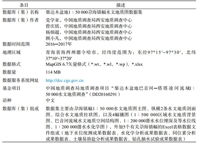
该图幅位于青海省海西州德令哈市,涵盖面积约420 km2。其水文地质图数据集的基本信息列于表 1,主要由1:50 000水文地质图主图、纵横2条水文地质剖面图、综合水文地质柱状图,以及4幅镶图(1:500 000区域水文地质背景图、巴音河流域水文地质空间结构图、1:200 000潜水水位埋深及等水位线图、1:200 000潜水水化学图),另加5个Excel表格数据文件组成。
|
|
表 1 数据库(集)元数据简表 |
柴达木盆地1:50 000水文地质图以满足政府决策、技术支撑部门,以及项目建设对水文地质资料和信息的需求,服务于水资源开发利用、生态环境保护为目标,围绕地下水水质水量、补给-径流-排泄条件、地下水与生态植被关系,以及开发利用等方面,采集、处理野外调查获取的最新数据和已有资料与成果数据,形成图幅的水文地质图数据集。其中,编绘水文地质图时,对《水文地质图编制规范(1:50 000)》未涉及的内容与表达方法,参考了1979年原国家地质总局编写的《综合水文地质图编图方法与图例》一书。
2.1 数据采集该图幅水文地质信息数据涵盖地层岩性、含水岩组与空间分布、地下水水质水量、水位埋深、包气带岩性与结构、土壤含盐量、生态植被类型与分布、地下水开发利用等方面。数据采集,一是通过收集前人工作资料及成果获得;二是通过购买和解译Spot-6遥感数据获得;三是通过地面路线调查(包括机井、民井调查,水土样采集与测试,地下水位统测等)、施工水文地质勘探孔并进行抽水试验获得。
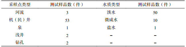
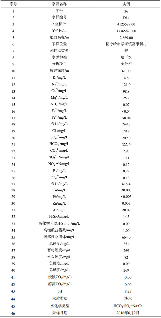
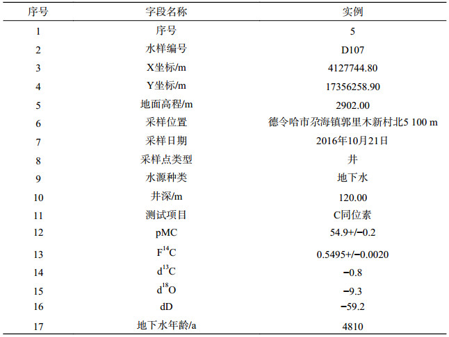
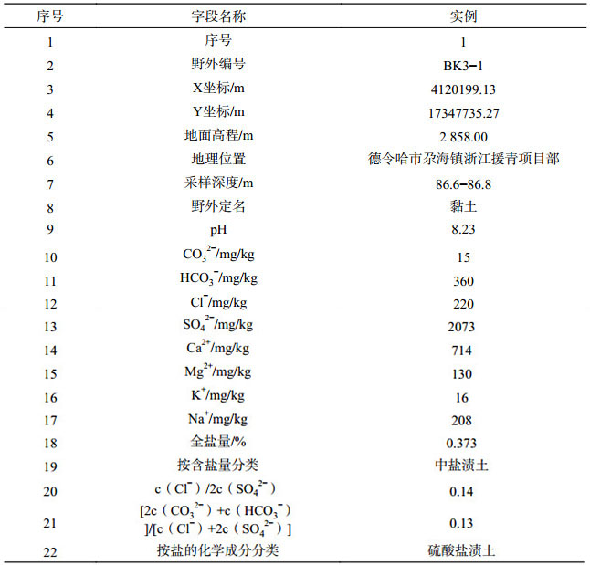
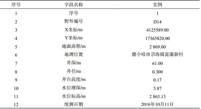
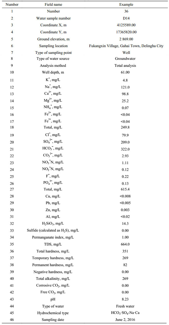
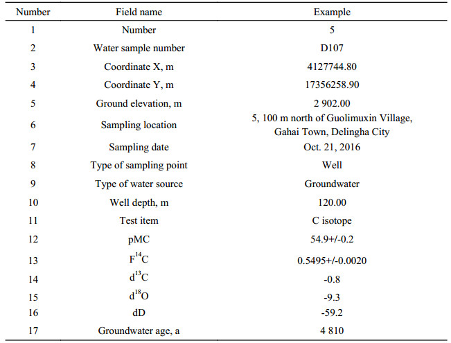
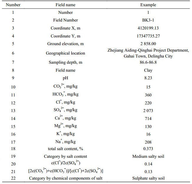
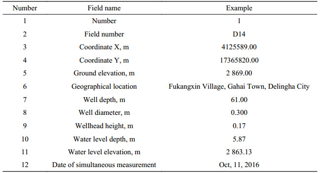
为获得尕海镇幅的水文地质信息,调查工作在图幅内安排了16条南北走向的地面调查路线,获取了226个机井、民井、泉、河流、浅井等调查点的相关数据。同时,通过对134眼机井和民井的调查、47个已有钻孔柱状图、抽水试验综合成果表进行数据提取,以及对本次施工的1眼勘探孔岩心进行编录和抽水试验,获取了地表至地面以下508 m深度的地下含水层的地层岩性空间分布特征、地下水水力性质、水质水量和水位的基本数据。为准确可靠地确定地下水流场,本次研究工作对包括本图幅在内的山前平原区地下水进行了水位统测。完成的工作量满足《水文地质调查规范(1:50 000)》(DZ/T 0282-2015)规定的工作量定额要求。上述工作采集水质简分析样35件、全分析样26件、土壤易溶盐样55个、氢氧同位素样及14C同位素样12件,获得地下水位统测数据68个。尕海镇幅水样采样点类型和水质类型统计表见表 2。水质及土壤易溶盐样由具有国家计量认证的青海省水文地质工程地质环境地质调查院实验室测试,氢氧同位素样由西安地质调查中心实验测试中心测试,14C同位素样由美国Beta Analytic Inc.测试。
|
|
表 2 1:50 000尕海镇幅水样采样点类型和水质类型统计表 |
(1)含水岩组与空间分布数据处理。主要从已有钻孔柱状图和本次施工的勘探孔岩心提取岩性层空间位置,在此基础上进行含水层和隔水层划分,并绘制成在纵向和横向上能够控制全区的水文地质剖面,确定出含(隔)水层的厚度分布范围及其空间变化特征,并据此编制水文地质综合柱状图。
(2)含水层水质水量和渗透系数等参数的获取与数据处理。通过勘探孔、机井、民井的抽水试验获取含水层的涌水量、水位降深和渗透系数等参数,并将不同时期、不同口径的钻孔获取的涌水量数据统一按降深10 m、井径200 mm的标准转换为换算涌水量;在此基础上,再将换算涌水量按照 > 5000 m3/d、5000~3000 m3/d、3000~1000 m3/d、1000~300 m3/d、< 300 m3/d共五个级别,进行富水性等级划分,编制水文地质图主图和水文地质剖面图。
(3)地下水水位数据处理。从野外调查的机井、民井、浅井、钻孔,以及地下水位统测,获取图幅内第四系潜水面的埋深和水位标高,并使用这些数据绘制潜水水位埋深及等水位线图,以镶图形式辅助反映图幅区的水文地质条件。
(4)地下水与植被生态关系数据的处理。结合遥感解译、野外调查和图幅以外的区域规律,统计生态植被分布区的地下水位埋深和溶解性总固体(TDS)、土壤含盐量等信息数据,确定依赖地下水的生态植被的分布范围,并将该分布范围标绘于水文地质主图面。根据地下水水化学数据,分别生成TDS含量等值线和水化学类型,并据此绘制潜水水化学图,也以镶图形式辅助反映图幅区的水文地质条件。
(5)地下水系统数据的处理。图幅区是巴音河山前平原地下水系统的一部分,利用区域认识和成果编绘区域水文地质背景图和流域水文地质空间结构图,以镶图形式加以反映。
通过以上的数据处理与加工,最终形成了尕海镇幅1:50 000水文地质数据集和水文地质图。
3 数据样本描述尕海镇幅水文地质图数据集包括1:50 000水文地质图图形数据库和5个Excel表格数据文件。数据库建设参考了庞健峰等(2017)《1:100万中华人民共和国地质图空间数据库》,以及侯建军等(2017)《内蒙古自治区阿拉善左旗腾格里工业园区供水水文地质详查数据集》等论文的方法和表达形式,具体如下。
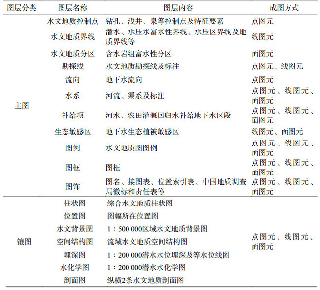
(1)图形数据库由水文地质图主图和一系列镶图组成。主图内容主要包括水文地质控制点、水文地质界线、含水岩组富水性分区、水文地质勘探线、地下水流向、河水等补给地下水区段和地下水生态植被敏感区等内容;镶图包括综合水文地质柱状图、图幅所在位置图、区域水文地质背景图、流域水文地质空间结构图、潜水水位埋深及等水位线图、潜水水化学图和2条水文地质剖面图等。具体图层划分见表 3。
|
|
表 3 尕海镇幅1:50 000水文地质图图层划分表 |
尕海镇幅1:50 000水文地质图图形数据库空间投影参数如下:
坐标系类型:投影平面直角
椭球参数:西安80/1975年IUGG推荐椭球
投影类型:高斯-克吕格(横切椭圆柱等角)投影
比例尺:1:50 000
坐标单位:毫米(mm)
投影中心点经度:990 000
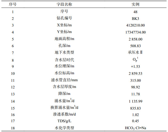
(2)5个Excel表格数据文件分别为:尕海镇幅钻孔抽水试验成果数据表.xlsx(表 4)、尕海镇幅水化学分析成果数据表.xlsx(表 5)、尕海镇幅同位素分析成果数据表.xlsx(表 6)、尕海镇幅土壤易溶盐分析成果数据表.xlsx(表 7)和尕海镇幅地下水位统测成果数据表.xlsx(表 8)。
|
|
表 4 尕海镇幅钻孔抽水试验成果数据表 |
|
|
表 5 尕海镇幅水化学分析成果数据表 |
|
|
表 6 尕海镇幅同位素分析成果数据表 |
|
|
表 7 尕海镇幅土壤易溶盐分析成果数据表 |
|
|
表 8 尕海镇幅地下水位统测成果数据表 |
野外水文地质调查采用国家地理信息中心1:50 000地理底图空间数据库数据,采样点位置采用手持GPS进行定点。为保证数据质量,按照质量管理要求对所采集的数据在野外调查时就按照小组内自检、小组与小组之间互检、项目负责人抽检,以及单位核查四个环节加以控制,保证原始数据的可靠性。水土样品的采集测试按相关要求操作,送检测试做好送样单和送样记录,样品由具有相应资质的测试单位完成,其中常规水质样和土壤易溶盐样分析测试单位青海省水文地质工程地质环境地质调查院实验室具有国家计量认证,保证了测试结果的可靠性。获得基本数据后,编图人员将所用的数据进行分类和列表统计,并注明资料出处和来源,另外安排他人对分类统计资料进行核对;编图过程中发现数据异常时,进一步核对并查明原因直至得到合理解释。图件编制完成后,再进行讨论与研读,审核所绘制的水文地质分区、水文地质界线以及地质体基础关系的合理性,最终形成图件定稿。此过程也是认识和发现水文地质现象与规律的过程,通过从基本数据到成图过程的质量管控,确保了数据质量以及对现象与规律认识的可靠性。
5 结论(1)2016年尕海镇幅1:50 000水文地质调查工作获取了尕海镇幅钻孔抽水试验成果数据(本次施工以及收集已有钻孔资料共48个钻孔),水化学(61个水样)、同位素(12个同位素样)和土壤易溶盐(55个土样)分析成果数据,地下水位统测成果数据(68个统测点)等大量数据。在此基础上,按照中国地质调查局组织编制并即将颁布实施的《水文地质图编制规范(1:50 000)》要求,编制了图幅的水文地质图。
(2)尕海镇幅水文地质图数据集包括尕海镇幅1:50 000水文地质图图形数据库和5个Excel表格数据文件。图形数据库由水文地质图主图和一系列镶图组成。5个Excel表格数据文件分别为:尕海镇幅钻孔抽水试验成果数据表、尕海镇幅水化学分析成果数据表、尕海镇幅同位素分析成果数据表、尕海镇幅土壤易溶盐分析成果数据表和尕海镇幅地下水位统测成果数据表。
(3)我国西北内陆干旱盆地多为大型的能源盆地,水文地质条件类似,地下水形成演化规律类似,开发利用形式也基本一致。地下水资源是西北城镇和经济工业园区供水的重要水源,水资源开发利用与环境保护面临类似的问题,对水文地质资料有着类似的需求和要求。柴达木盆地1:50 000尕海镇幅水文地质图数据集为当地和我国西北干旱地区类似盆地、类似地区水文地质调查数据采集、加工和成果表达提供了示范,将对1:50 000水文地质调查在西北地区干旱盆地形成标准化的数据和图件提供有益的借鉴。
致谢:尕海镇幅1:50 000水文地质图数据集数据的获得来自“柴达木盆地巴音河-塔塔凌河流域1:5万水文地质调查”项目成员的共同努力。感谢常亮、犹香智、李小等、王倩、卢娜等组员的辛勤工作。
1 IntroductionKnown as the “Treasure Bowl” of the country, the Qaidam Basin is an area rich in energy and mineral resources, and an area where potassium salt, a kind of strategic national resource, is concentrated and exploited. It was approved as one of the first batch of national circular economy industrial pilot parks by the State Council in 2005 (Yan LJ et al., 2010). This pilot park is situated in the arid inland of northwest China, a region known for low rainfall, a weak eco-environment, an extremely uneven spatial and temporal distribution of water resources (Xie XM et al., 2010; Bao ZY et al., 2010; Li CH et al., 2014). To construct the pilot park, hydrogeological work is urgently needed to provide basic information and data on the groundwater resources and the relationship between the groundwater and the eco-environment. Collecting the basic information and data on groundwater resources and then preparing hydrogeological maps has always been an important means for hydrogeological work to serve the public. Over the past years, a lot of scholars and frontline hydrogeological survey workers have prepared a large number of hydrogeological maps through improved field survey practices and innovation (Wu AM et al., 2016; Wang XF et al., 2016). However, these hydrogeological maps mostly reflect resource information such as water quality and volume and can hardly meet the needs of national development and construction in the new era for resource sharing and environmental protection. In 2016, the CGS implemented the project “1:50 000 Hydrogeological Survey of Bayin River - Tataling River Basin, Qaidam” (project code: DD20160291) in the Qaidam Basin, which lasted from 2016 to 2018 and was undertaken by the Xi’an Center, CGS. In 2016 and 2017, a hydrogeological survey for five 1:50 000 standard map sheets was carried out in the Delingha Basin on the northeastern edge of Qaidam in accordance with the requirements for equal prioritization of resources and environments, obtaining data covering the whole Bayin River piedmont plain of the Delingha Basin, including the stratum lithology; spatial distribution, structure and water yield properties of aquifers; groundwater recharge, runoff and discharge, water quality and volume as well as the relationship between groundwater and eco-vegetation. In 2018, in accordance with the Specification for Preparation of Hydrogeological Maps (1:50 000), which was developed under the guidance of the CGS and is to be issued and implemented, hydrogeological maps of the five map sheets were prepared, and among them were the Gahai Town hydrogeological maps.
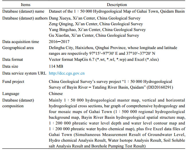
Gahai Town involves Delingha City in Haixizhou, Qinghai Province, and covers an area of about 420 km2. The basic information contained in the hydrogeological map dataset is presented in Table 1, consisting of the 1:50 000 hydrogeological master map, vertical and horizontal hydrogeological cross sections, a bar graph of comprehensive hydrogeology and four mosaic maps (1:500 000 regional hydrogeological background map, Bayin River Basin hydrogeological spatial structure map, 1:200 000 phreatic water level depth and water level contour map and 1:200 000 phreatic water hydro chemical map) and five Excel data files.
|
|
Table 1 Metadata Table of Database (Dataset) |
The 1:50 000 hydrogeological map of Qaidam is intended to meet the needs of government policy makers, technical support departments and project construction for hydrogeological data and information, in order to serve the objectives of water resource development, utilization and eco-environmental protection. It centers on groundwater quality and volume, the recharge-runoff-discharge condition, the relationship between groundwater and eco-vegetation, and development and utilization. Besides existing information and data, the dataset is prepared by collection and processing of the latest data obtained during field investigation. In preparing the hydrogeological map, the contents and expressions not covered in the Specification for Preparation of Hydrogeological Maps (1:50 000) are determined with reference to the book Comprehensive Hydrogeological Map Plotting Methods and Legends compiled by the former National Geological General Administration in 1979.
2.1 Data AcquisitionThe hydrogeological information and data contained in the Gahai Town map, includes stratum lithology, water-bearing rock formation and spatial distribution, groundwater quality and volume, water-level depth, aeration zone lithology and structure, salt content in soil, eco-vegetation types and distribution, and groundwater development and utilization. Data is acquired by the following means: 1) collecting the data and results obtained during previous surveys; 2) purchasing and interpreting Spot-6 remote sensing data; 3) performing investigations along the route (including investigation into pumping and domestic wells, sampling and testing of water and soil, simultaneous measurement of groundwater level), drilling hydrogeological boreholes and performing pumping tests.
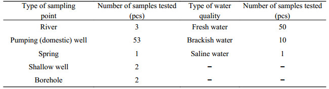
To obtain the hydrogeological information of Gahai Town, it was necessary to arrange and investigate 16 south-to-north routes within Gahai Town and thus acquire the relevant data of 226 investigation points, including pumping wells, domestic wells, springs, rivers and shallow wells. At the same time, it was necessary to acquire basic data on underground aquifers from the surface to a depth of 508 m below by investigating 134 pumping and domestic wells, extracting data from the comprehensive results datasheet of bar graphs and pumping test results of 47 existent boreholes, cataloging cores and carrying out pumping tests of one of the drilled exploratory wells for this survey. Such data include the spatial distribution characteristics of stratum lithology, hydraulic properties of groundwater, water quality, volume and level. To accurately and reliably determine the groundwater flow field, simultaneous measurement of the groundwater level was also performed for the piedmont plain area that includes Gahai Town. The completed workload met the requirements on workload quota specified in DZ/T 0282-2015 Specification for Hydrogeological Survey (1:50 000). During the survey, 35 water samples were taken for simple analysis of water quality, 26 samples for total analysis of water quality, 55 samples for analysis of soluble salt in soil, 12 samples for analysis of hydrogen and oxygen isotopes and 14C isotopes, obtaining 68 simultaneous measurement results of groundwater level. Statistics related to water sampling and water quality types at Gahai Town are shown in Table 2. The samples for analysis of water quality and soluble salts in the soil were tested in the laboratory of the Qinghai Institute of Hydrogeology, Engineering Geology and Environmental Geology, which holds a national metrological certificate. The samples for analysis of hydrogen and oxygen isotopes were tested at the Research Center of the Xi’an Center, CGS, while the samples for analysis of 14C isotope were tested by Beta Analytic Inc., a company of the USA.
|
|
Table 2 Statistics of Water Sampling Point Type and Water Quality Type for the 1:50 000 Hydrogeological Survey in Gahai Town |
(1) Processing of data on water-bearing rock formation and its spatial distribution. Determine the lithological layers’ spatial location by extracting data from the bar graphs of existing boreholes and the core of the boreholes drilled for this project. Based on this, identify the aquifers and aquicludes and plot hydrogeological cross sections for the whole region, both vertically and horizontally. Then determine the thickness distribution scope and spatial variation characteristics of aquifers (aquicludes). Then map the bar graph of comprehensive hydrogeology based on this.
(2) Acquisition and processing of parameters such as water quality, volume and the permeability coefficient of the aquifer. First obtain the parameters of the aquifer, such as water yield, drawdown and permeability coefficient through pumping tests of exploratory boreholes, pumping wells and domestic wells. Then, convert the water yield data of boreholes of different diameters in different phases to that under the conditions of a drawdown of 10 m and a diameter of 200 mm. Then divide the converted water yield data into five levels of water yield property, i.e. > 5000 m 3/d, 5000~3000 m3/d, 3000~1000 m3/d, 1000~300 m3/d and < 300 m 3/d. Finally, prepare the hydrogeological master map and the hydrogeological cross section.
(3) Processing data of groundwater levels. Derive the water-level depths and elevations of the Quaternary phreatic waters in Gahai Town from field investigation results of pumping wells, domestic wells, shallow wells and drilled boreholes, as well as simultaneous measurement results of groundwater level. Then prepare phreatic water-level depth and water-level contour maps to reflect the hydrogeological conditions in Gahai Town in the form of a mosaic map.
(4) Processing data showing the relationship between groundwater and vegetation ecology. In conjunction with the interpretation of remotely sensed data, field survey results and patterns of areas beyond Gahai Town, make statistics of data concerning the groundwater level depths, total dissolved solids (TDS) and salt content in soil in the region where ecological vegetation is distributed, so as to determine the distribution scope of groundwater-dependent ecological vegetation. Depict the scope on the hydrogeological master map. Based on the hydrochemical data of groundwater, generate the TDS content isoline and hydrochemical types and prepare the phreatic water hydrochemical map to reflect the hydrogeological conditions in Gahai Town in the form of a mosaic map.
(5) Processing data of the groundwater system. Gahai Town is a part of the groundwater system of the Bayin River piedmont plain. Prepare the regional hydrogeological background map and the basin’s hydrological spatial structural map based on regional understanding and results, to reflect the hydrogeological conditions in Gahai Town in the form of a mosaic map.
Through the aforementioned data processing, the Gahai Town 1:50 000 hydrogeological dataset and map are finally established.
3 Description of Data SamplesThe dataset of the hydrogeological map of Gahai Town includes the graphical database of the 1:50 000 hydrogeological map and five Excel files. By reference to the methods and expressions in papers such as The National 1:1 000 000 Geological Map Spatial Database (Pang JF et al., 2017), the Dataset of Detailed Hydrogeological Investigation for Water Supply in Tengri Industrial Park, Alxa Left Banner, Inner Mongolia Autonomous Region (Hou JJ et al., 2017), the database is established as below.
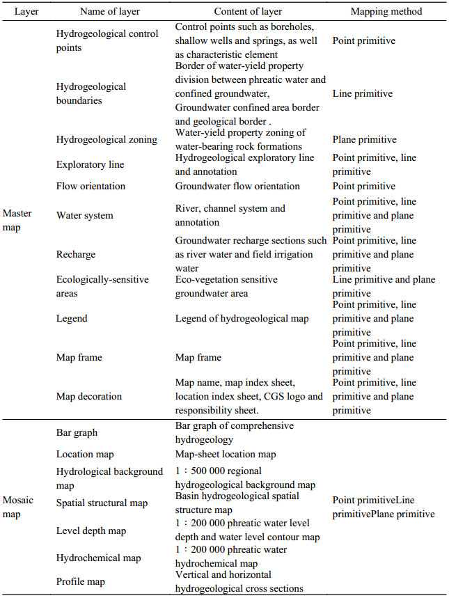
(1) The graphical database consists of the hydrogeological master map and a series of mosaic maps. The master map consists primarily of hydrogeological control points, hydrogeological boundaries, water-yield property based zones of water-bearing rock formations, hydrogeological exploratory lines, groundwater flow orientation, groundwater recharge sections such as river water and ecologically-sensitive groundwater areas. Mosaic maps include a bar graph of comprehensive hydrogeology, map-sheet location, regional hydrogeological background map, basin hydrogeological spatial structural map, phreatic water level depth and water level contour map, phreatic water hydrochemical map and two hydrogeological cross sections. See Table 3 for details.
|
|
Table 3 Layers Division of 1:50 000 Hydrogeological Map of Gahai Town |
The parameters of the spatial projection of the graphical database of the 1:50 000 hydrogeological map of Gahai Town are presented below:
Type of coordinate system: planar rectangular projection
Ellipsoidal parameter: Xi’an 80/ellipsoid recommended by IUGG in 1975
Projection type: Gauss-Kruger projection (transverse elliptic cylindrical equal angle)
Scale: 1:50 000
Unit: millimeter (mm)
Longitude of the projection central point: 990 000
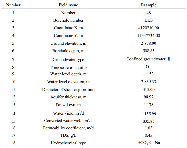
(2) The five Excel files are Borehole Pumping Test Results of Gahai Town.xlsx (Table 4), Hydrochemical Analysis Results of Gahai Town.xlsx (Table 5), Water Isotope Analysis Results of Gahai Town.xlsx (Table 6), Soil Soluble Salt Analysis Results of Gahai Town.xlsx (Table 7) and Simultaneous Measurement Results of Groundwater Level of Gahai Town.xlsx (Table 8) respectively.
|
|
Table 4 Borehole pumping test results of Gahai Town |
|
|
Table 5 Hydrochemical Analysis Results of Gahai Town |
|
|
Table 6 Water Isotope Analysis Results from Gahai Town |
|
|
Table 7 Soil Soluble Salt Analysis Results from Gahai Town |
|
|
Table 8 Simultaneous Measurement Results of Groundwater Level of Gahai Town |
The data in the 1:50 000 geographical base map spatial database issued by the National Geographical Information Center were adopted for the field hydrogeological survey. and the sampling location was positioned by using a handheld GPS. During field investigation, self inspection in groups, mutual inspection between groups, sampling inspection by project manager and checks by the Xi’an Center, China Geological Survey were conducted for the acquired data according to management requirements. In this way, the reliability of the raw data is guaranteed. According to the relevant requirements, soil and water sampling and testing were conducted by organizations with corresponding qualifications and the sample delivery sheets and records were well-kept. For example, the water samples used for quality analysis and the soil samples used for soluble salt analysis were tested and analyzed by the laboratory of the Qinghai Institute of Hydrogeology, Engineering Geology and Environmental Geology, which holds a national metrological certificate. In this way, the reliability of the test results was guaranteed. After obtaining the basic data, the mapping personnel classified and tabulated the data with the sources clearly indicated. Relevant personnel were specially selected to verify the data. Any piece of data indicated to be abnormal during the mapping was subject to further verification and investigation, until it was justified to be reasonable. After completion of the preparation, discussion and study of the maps were carried out to examine the reasonableness of the hydrogeological zones, hydrogeological boundaries and the basic relationships of the geological bodies. Only after this stage was the map finalized. This process also aided in understanding and discovering hydrogeological phenomena and patterns. By the aforementioned quality control, from basic data acquisition to mapping process, the data quality and reliable understanding of the phenomena and patterns were ensured.
5 Conclusions(1) During the 1:50 000 hydrogeological survey of Gahai Town in 2016, a large amount of data was acquired, including results of borehole pumping tests (48 boreholes in total, including both those drilled for the survey as well as already existing according to data previously collected) and the analytical results of the water chemistry (61 water samples), isotope (12 isotope samples) and soluble salts in soil (55 soil samples) as well as the results of the simultaneous measurement of groundwater level (68 simultaneous-measurement points). Based on these data, the 1:50 000 hydrogeological map of Gahai Town was prepared in accordance with the Specification for Preparation of Hydrogeological Maps (1:50 000) which was prepared under the guidance of the CGS and is scheduled to be issued and implemented.
(2) The dataset of the hydrogeological map of Gahai Town includes the graphical database of the 1:50 000 hydrogeological map and five Excel files. The graphical database consists of the hydrogeological master map and a series of mosaic maps. The five Excel data files are Borehole Pumping Test Results of Gahai Town.xlsx (Table 4), Hydrochemical Analysis Results of Gahai Town.xlsx (Table 5), Water Isotope Analysis Results of Gahai Town.xlsx (Table 6), Soil Soluble Salt Analysis Results of Gahai Town.xlsx (Table 7) and Simultaneous Measurement Results of Groundwater Level of Gahai Town.xlsx (Table 8).
(3) Most basins in inland arid regions of northwest China are large-scale energy basins, which are similar in hydrogeological conditions and the formation, evolution, development and exploitation mode of the groundwater. Groundwater resources are important for water supply to the towns, cities, economic and industrial parks in these areas. The development and utilization of water resources and environmental protection face similar challenges, and have similar demands and requirements for hydrogeological data. The dataset of the 1:50 000 hydrogeological map of Gahai Town, Qaidam, has set an example of best practice for the acquisition, processing and expression of the results of hydrogeological survey data for similar basins and areas in the inland arid regions of northwest China, and will provide a positive reference for the 1:50 000 hydrogeological survey in these areas to form standardized data and maps.
Acknowledgement: The data in the dataset of the 1:50 000 hydrogeological map of Gahai Town is made available, thanks to the joint efforts of members of the project “1:50 000 Hydrogeological Survey of Bayin River - Tataling River Basin, Qaidam”, including CHANG Liang, YOU Xiangzhi, LI Xiaodeng, WANG Qian, and LU Na, to name just a few.
保正岳, 董西锋, 郭世珍, 徐维成. 2010. 柴达木盆地地下水资源开发利用中存在的问题及对策[J]. 青海大学学报(自然科学版), 28(1): 54-59. DOI:10.3969/j.issn.1006-8996.2010.01.013 |
国家地质总局. 1979. 综合水文地质图编图方法与图例[M]. 北京: 地质出版社.
|
侯建军, 王宇, 郑泉, 蒙奎文, 刘忠辉. 2017. 内蒙古自治区阿拉善左旗腾格里工业园区供水水文地质详查数据集[J]. 中国地质, 44(S1): 88-95. |
李春花, 罗正霞, 陈蓉, 黄芸玛. 2014. 水资源约束下柴达木盆地循环经济发展研究[J]. 资源开发与市场, 30(5): 582-591. DOI:10.3969/j.issn.1005-8141.2014.05.017 |
庞健峰, 丁孝忠, 韩坤英, 曾勇, 陈安蜀, 张艳玲, 张庆合, 姚冬生. 2017. 1:100万中华人民共和国地质图空间数据库[J]. 中国地质, 44(S1): 8-18. |
王新峰, 李伟, 曹红, 刘艳, 肖攀, 何锦. 2016. 基岩山区水文地质图编制新模式与实践[J]. 人民黄河, 38(5): 10-14. DOI:10.3969/j.issn.1000-1379.2016.05.003 |
吴爱民, Giovanni Conte, Lucio Martarelli, 马荣. 2016. 意大利水文地质调查编图指南解读及其借鉴意义[J]. 水文地质工程地质, 43(5): 166-172. |
谢新民, 魏传江, 柴福鑫, 李青基, 贾福宏, 庞恒通. 2010. 青海省柴达木循环经济试验区水资源配置及其开发利用策略研究[J]. 水利规划与设计, (6): 1-5. DOI:10.3969/j.issn.1672-2469.2010.06.1 |
闫丽娟, 李丹, 欧阳晓红, 郭富庆, 王学凤. 2010. 柴达木循环经济试验区水资源配置原则与思路[J]. 水利发展研究, (12): 44-47. DOI:10.3969/j.issn.1671-1408.2010.12.013 |
Bao Zhengyue, Dong Xifeng, Guo Shizhen, Xu Weicheng. 2010. Main Problem and Solutions of Chaidamu Basin Groundwater Resources exploitation[J]. Journal of Qinghai University (Nature Science), 28(1): 54-59 (in Chinese with English abstract). |
National Bureau of Geology. 1979. Integrated Hydrogeological Map Mapping Method and Legend[M]. Beijing: Geological Publishing House (in Chinese).
|
Hou Jianjun, Wang Yu, Zheng Quan, Meng Kuiwen, Liu Zhonghui. 2017. Dataset of detailed hydrogeological investigation for water supply in Tengri Industrial Park, Alxa Left Banner, Inner Mongoli Autonomous Region[J]. Geology in China, 44(S1): 108-117. |
Li Chunhua, Luo Zhengxia, Chen Rong, Huang Yunma. 2014. Research on Development of Circular Economy under Constraints of Water Resources in Qaidam Basin[J]. Resource Development & Market, 30(5): 582-585, 591 (in Chinese with English abstract). |
Pang Jianfeng, Ding Xiaozhong, Han Kunying, Zeng Yong, Chen Anshu, Zhang Yanling, Zhang Qinghe, Yao Dongsheng. 2017. The national 1:1 000 000 geological map spatial database[J]. Geology in China, 44(S1): 10-23. |
Wang Xinfeng, Li Wei, Cao Hong, Liu Yan, Xiao Pan, He Jin. 2016. Initial Analysis and Practices of Bedrock Mountainous Hydrogeology Mapping Theory[J]. Yellow River, 38(5): 10-14 (in Chinese with English abstract). |
Wu Aimin, Giovanni Conte, Lucio Martarelli, Ma Rong. 2016. Understanding and Discussions on Hydrogeological Map of Italy-Guidelines to Survey and Mapping[J]. Hydrogeology & Engineering Geology, 43(5): 166-172 (in Chinese with English abstract). |
Xie Xinmin, Wei Chuanjiang, Chai Fuxin, Li Qingji, Jia Fuhong, Pang Hengtong. 2010. Study on Water Resources Allocation and Development and Utilization Strategy of Qaidam Circular Economy Experimental Zone in Qinghai Province[J]. Water resources planning and design, (6): 1-5 (in Chinese). |
Yan Lijuan, Li Dan, Ouyang Xiaohong, Guo Fuqing, Wang Xuefeng. 2010. Principles and Thoughts on Water Resources Allocation in Chaidamu Circular Economy Experimental Area[J]. Water development research, (12): 44-47 (in Chinese). |