2. 自然资源部矿产勘查技术指导中心, 北京 100120
2. Mineral Exploration Technical Guidance Center, Ministry of Natural Resources, Beijing 100120, China
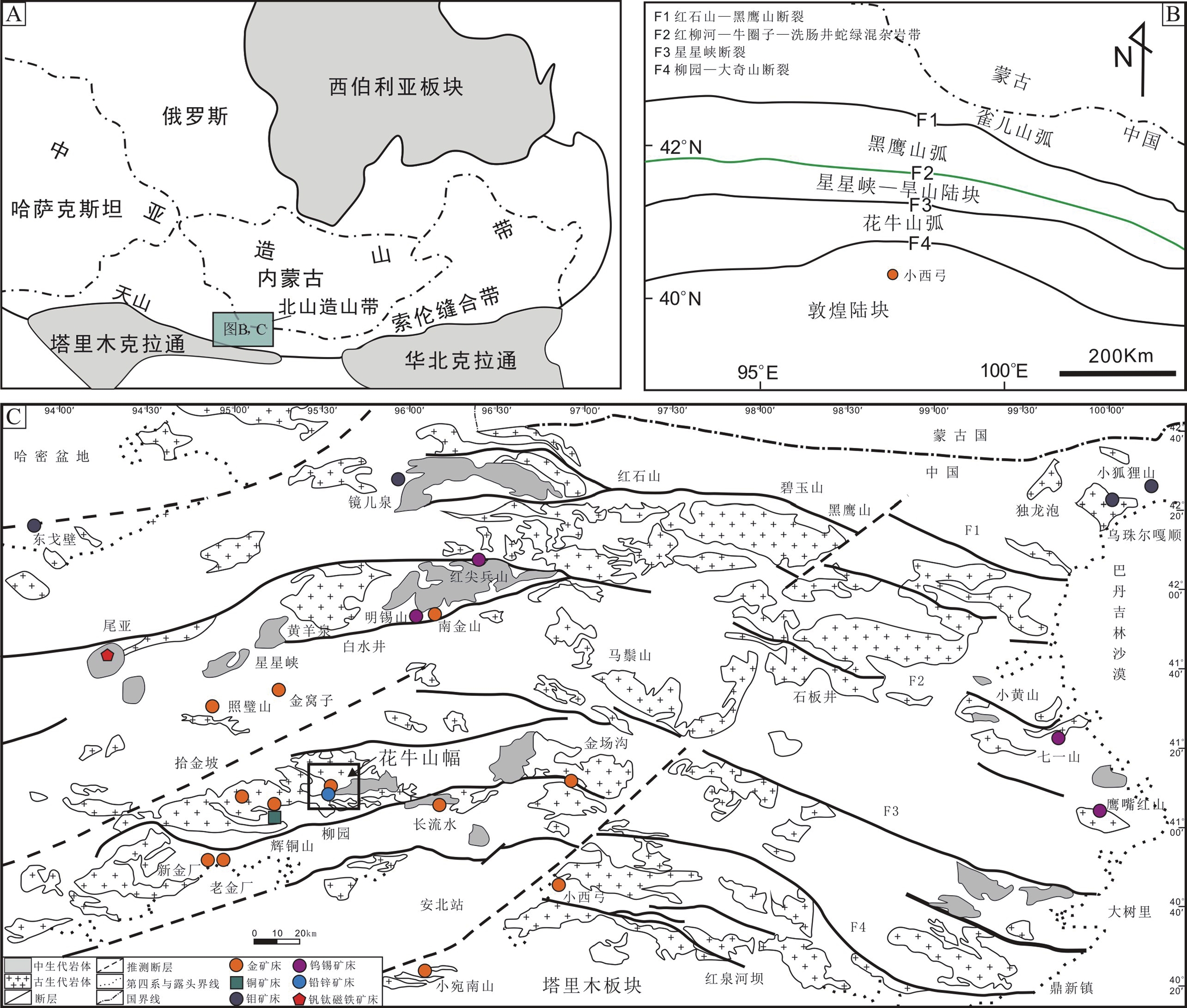
北山地区位于天山造山带的东部(图1A),地处哈萨克斯坦和塔里木板块交汇部位。北山地区产出多条近东西向的蛇绿岩带和深大断裂(图1B),由南向北可分为敦煌陆块、花牛山弧、星星峡−旱山地块、黑鹰山弧和雀儿山弧❶(左国朝和何国琦,1990)。自寒武纪初期以来,经历了两期板块构造体制和两次主要的俯冲−碰撞造山作用,多期次构造−岩浆演化旋回(孙新春等,2011),为成矿作用提供了有利条件。区内NWW-SEE向韧性剪切带,严格控制了金矿的形成及分布。工作区位于北山地区的南部,大地构造位置属塔里木板块敦煌地块北缘(图1),南邻柳园−大奇山深大断裂。
|
图 1 北山造山带大地构造位置图(A)、北山地区构造单元划分图(B)和北山地区区域地质简图(C) 图A据Kröner A et al., 2008;图B据Xiao WJ et al., 2010;图C据苗来成等, 2014,修改 |
北山地区1∶50 000区域地质调查工作主要开展于20世纪80年代到90年代,花牛山幅已在上世纪80年代完成区域地质调查工作,同时完成了1∶50 000土壤测量、1∶50 000磁法测量、1∶50 000重砂测量。同时,前人对该地区的构造环境、岩石特征等方面也进行了大量研究(殷勇和殷先明,2010;余吉远等,2015)。这些前期工作为花牛山幅地质矿产图的编制奠定了基础。花牛山幅1∶50 000地质矿产图作为中国地质调查局矿产地质调查的示范图件,力争反映新一轮矿产调查工作中取得的地质调查、矿产勘查以及科研新成果,为该地区的矿产资源研究、能源勘探等提供基础地质图件,为科研和野外地质调查提供有益的参考资料。甘肃省花牛山幅1∶50 000矿产地质图数据库的元数据简表如表1所示。
|
|
表 1 数据库(集)元数据简表 |
甘肃省花牛山幅1∶50 000矿产地质图以《矿产地质调查技术要求(1∶50 000)》(DD 2019-02)为基本要求,以“三位一体”勘查区找矿预测理论为指导,以甘肃省花牛山幅1∶50 000区域地质调查原始资料❷(包括实际材料图、剖面图、记录本)为基础,并充分结合了本次花牛山幅1∶50 000矿产地质填图新成果。地理底图采用国家测绘地理信息局最新地理数据。应用已有的技术标准和数字填图系统(DGSS)、MapGIS等计算机软件进行数据处理。
2.2 数据处理过程 2.2.1 数据准备将收集到的区域地质调查成果和实际材料图进行数字化处理,形成MapGIS点、线、面文件。根据花牛山幅范围生成1∶50 000标准图框,投影系统为高斯−克吕格投影参数,坐标系统为西安80。
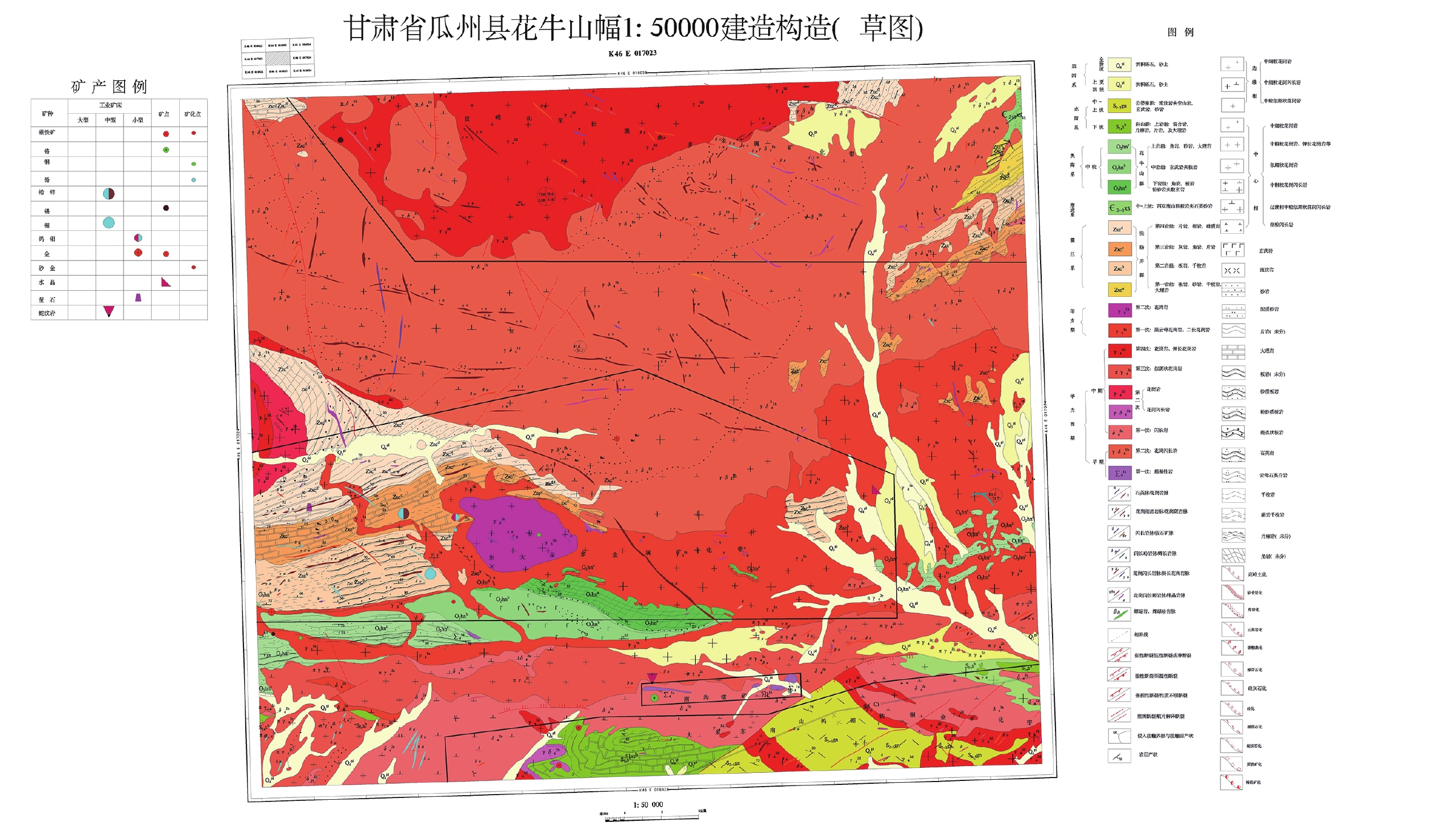
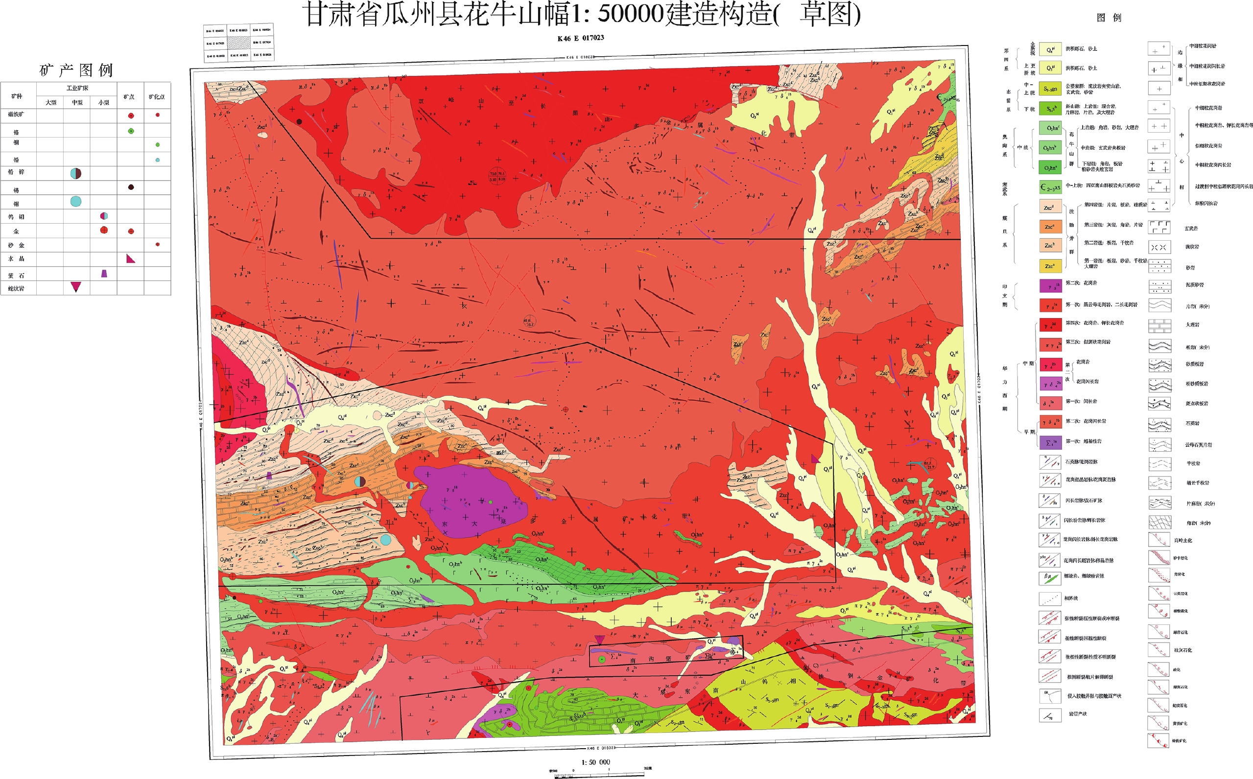
2.2.2 编制建造−构造草图通过查阅和分析花牛山幅1∶50 000区域地质调查报告❷中涉及的实测剖面、野外路线记录等实际材料,分解组一级编图单元,补充岩性(组合)界线,并将野外记录以岩性建造花纹点或线的形式表达在实际材料图上(图2)。
|
图 2 花牛山幅1∶50 000建造构造草图 |
(1)建造
按照统一的用色标准,使用不同颜色的面元表达建造的时代,使用建造花纹表达建造类型,并用相应的花纹表达岩石组合,代号用岩性+时代表达。其中,沉积岩建造中的钙质岩层、海相火山岩夹层使用岩性岩相界线作为界线,并按照相应的花纹表达建造,用不同颜色表达时代含义。
(2)脉岩
按照统一的用色标准使用面元的颜色表达岩性,代号用岩性代号表示。
(3)构造
按照统一的用色标准使用红色统一表示,用不同线型表达断裂性质。
(4)地质剖面
使用标准剖面线型+剖面代号表达位置,并以地质点及编号表达实际控制点情况,以相应的花纹表达各层岩性,同时在地质剖面上表达产状要素。
(5)化石采样点
按照统一的用色标准+子图样式表达位置及化石类型,并建立数据库。
(6)岩石化学样品采样点
使用标准子图号+样品编号表达采样点位置,并建立数据库。
(7)地球化学样品采样点
使用标准子图号+样品编号表达采样点位置,并建立数据库。
(8)同位素样品采样点
使用标准子图号+样品编号表达采样点位置,并建立数据库。
2.2.3 野外专项地质填图根据已有资料的综合分析整理和建造−构造草图的编制,划分重点工作区和一般工作区,确定了专项地质重点填图内容为晚三叠世侵入岩、矿化蚀变、构造、脉岩等。以数字填图掌上电脑中1∶250 000实际材料图为底图,通过野外实际路线调查,在数字填图系统中标绘出地质点、界线点和地质界线及路线等点、线信息,观察并录入各点的性质、岩性、产状等信息,初步建立数字填图(PRB)数据库。
地质点(P):分为界线点和观测点。在野外需要在系统中填写简单的属性,包括点号、点性、微地貌、露头情况、风化程度、位置说明、填图单元和接触关系,坐标信息由系统自动读取。
地质路线(R):野外需要在系统中填写的属性包括路线号、地质点号、路线编号、方向角、本站距离、累计距离、填图单元和岩石名称。其中,方向角、本站距离、累计距离为系统自动计算。
地质界线(B):野外需要在系统中填写的属性包括路线号、地质点号、B编号、R编号、界线类型、左侧填图单位、右侧填图单位、接触关系、走向、倾向以及倾角。
对沿途所见的地质产状和采集的标本信息,可随时在系统中定位录入相关信息,填写属性数据。
2.2.4 室内数据整理(1)将野外采集的地质点(P)、地质路线(R)、地质界线(B)数据资料导入电脑中,并根据相应规范进行数据整理。
①地质点(P)过程基本要求:路线号、风化程度、接触关系等信息按照实际情况填写完整,填图单位填写相应填图单元代号,岩石名称与地质描述对话框中保持一致(包括颜色、结构、构造等),批注信息为薄片鉴定结果,并按照实际情况综合定名后填写。
②地质路线(R)过程基本要求:R在室内按照“光滑曲线—修改线参数(线性1颜色1线宽0)—点间路线计算—(统计工作量)”进行。补充完善R属性数据库,并在进行路线地质描述前重新计算方位和距离。
③地质界线(B)过程基本要求:在室内计算机上用剪短线、延长线或者重新画线的方法按照接触情况对地质界线进行美化。统一颜色、线性及线宽等参数。补充地质界线描述信息,用“左侧为xxx,右侧为xxx”来说明界线两侧岩性,默认左侧为先观察的岩性,右侧为后观察到的岩性,并对两种岩性的接触关系及其证据加以表述。
④路线中的产状、采样、照片要求:补充产状、采样等相应属性描述信息。产状编号在换地质点后重新从1、2、3等开始编号,照片按照要求导入后在照片详细描述中对照片内容及所反映地质现象进行描述。
(2)将以本次野外实际采集的PRB数据为主的实际材料图与编制建造−构造草图时整理的区域地质调查实际材料图进行合并,对地层单元界线、建造花纹、反映各类建造的构造形态进行修正,对新形成的地质单元的界线进行勾连。
2.2.5 编制各类角图(1)建造柱状图:对主图中岩石地层单元的建造特征进行详细表达。通过对图幅内各类建造与构造及其与矿化的关系进行综合分析研究,编制沉积岩建造柱状图、火山岩建造柱状图、侵入岩建造柱状图、变质岩建造柱状图。
(2)典型矿床角图:包括典型矿床花牛山岩浆热液型铅锌矿床成矿要素图及12线地质剖面图,为本区的找矿预测工作提供参考。在收集以往资料❸❹成果的基础上,充分借鉴本次典型矿床野外实地调查与综合研究的成果,编制了典型矿床的角图部分。
(3)图切剖面:图幅内建造和构造的总体走向为北东向和东西向,为了能有效反映图幅内总体建造和构造特征及其与矿化的关系,布置了一条为近南北向、另一条为北西西向的贯穿全区的图切剖面,分别控制南华系−震旦系地层、晚泥盆系花岗岩和晚三叠纪花岗岩、泥盆系、奥套系火山岩建造。表达方式主要使用了标准剖面线型+标准代号表达位置,并以地质点及编号表达实际控制点情况,以相应的花纹表达各层岩性,同时在地质剖面上表达产状要素。
(4)矿产地名录:对本区的矿产地按照矿产地名称、规模、类型、主要含矿建造等方面进行了分析,编制矿产地名录,有利于对整个花牛山幅区域内矿产情况的了解。
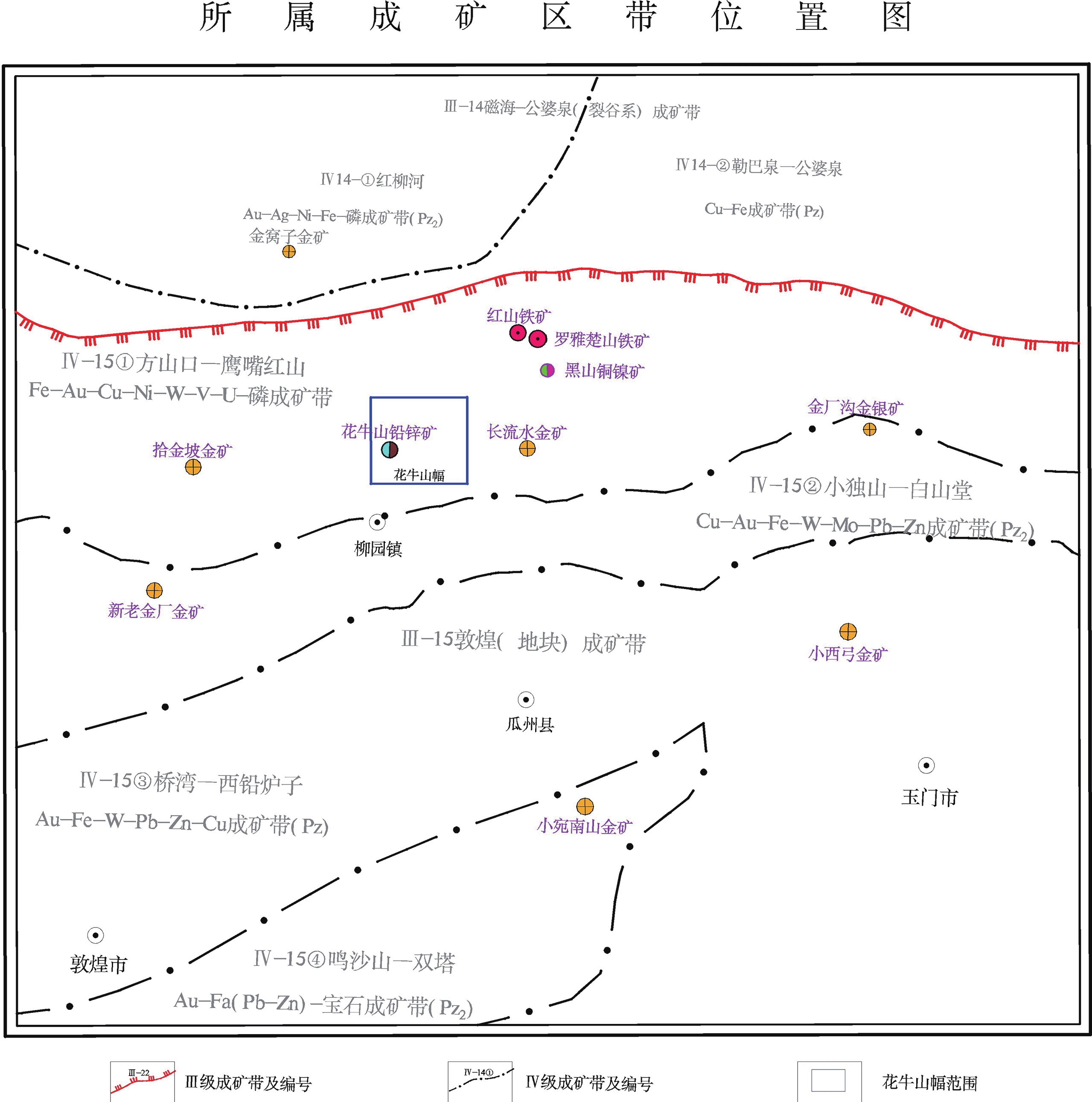
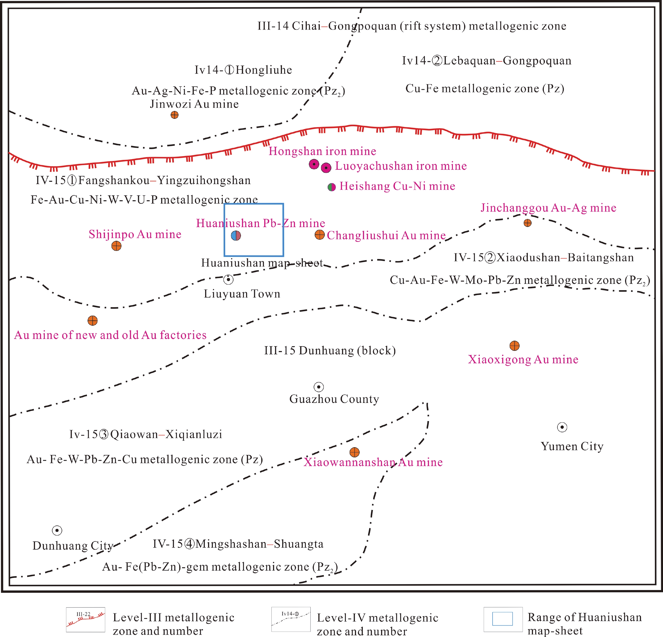
(5)所处成矿区带位置图:表达了花牛山幅在区域大地构造中所处的位置及其区域地质背景情况(图3)。在收集甘肃省1∶500 000区域成矿规律图❺的基础上,根据图幅位置确立的区域轮廓范围对本图进行裁剪,保留Ⅰ-Ⅳ成矿区带和主要的地名、矿床。然后进行缩放,生成花牛山幅所属成矿区带的角图部分。区域轮廓范围必须满足以下4个条件:A)以工作图幅为中心位置;B)以能包括工作区预测矿产的完整区域成矿带范围;C)以能包括预测矿产区域所属成矿带的相关区域构造带完整范围;D)以能包括预测矿产相关的成矿地质体控(成)岩构造带相对完整范围。
|
图 3 成矿区带所处位置图 |
(6)其他角图:对脉岩、构造、矿化蚀变图例进行梳理,编制各种图例。
3 数据样本描述 3.1 数据的命名方式地质面.wp,地质线.wl,地质点.wt。
3.2 图层内容主图内容包括沉积岩建造、火山岩建造、侵入岩建造、变质岩建造、第四系、构造、地质界线、产状、矿产地、矿化蚀变、各类代号等。
角图内容包括接图表、柱状图、图例、图切剖面、典型矿床成矿要素图、典型矿床实测剖面图、矿产地名录、所属成矿区带位置图、责任表等。
3.3 数据类型实体类型名称:点、线、面。
点实体:各类地质体符号及标记、地质花纹、矿产地、矿化蚀变;
线实体:断裂构造、地质界线、岩相界线等;
面实体:沉积岩、火山岩、变质岩、侵入岩、第四系等。
3.4 数据属性花牛山幅(K46E017023)1∶50 000矿产地质图数据库包含地质实体要素信息、地理要素信息和地质图整饰要素信息。地理要素信息属性沿用国家测绘地理信息局收集数据的属性结构。地质实体要素信息属性按照1∶50 000矿产地质调查专项地质填图数据库建库要求分四大岩类(沉积岩、火山岩、侵入岩、变质岩)、断裂构造、产状要素、矿产地等分别建立数据库属性。
沉积岩建造数据属性主要有:年代地层单位、岩石地层单位、建造名称、建造代码、岩性组合、地层时代、建造厚度、建造含矿性、岩石结构、沉积构造、岩石颜色、沉积作用类型、沉积相类型、同沉积构造。
火山岩建造数据属性主要有:年代地层单位、岩石地层单位、建造名称、建造代码、地层时代、地层分区、岩性组合、建造厚度、建造含矿性、火山喷发旋回、火山喷发类型、火山岩成因类型、特殊岩性夹层、火山岩相类型、同位素年龄。
侵入岩建造数据属性主要有:建造名称、建造代码、岩性组合、建造含矿性、岩石结构、岩石构造、侵入期次、岩体产状、平面形态、剖面形态、岩体侵位构造特征、接触带特征、成因类型、同位素年龄。
变质岩建造数据属性主要有:年代地层单位、岩石地层单位、建造名称、建造代码、岩性组合、地层时代、建造厚度、建造含矿性、岩石结构、岩石构造、原岩建造、变质相、变质作用类型。
断裂构造数据属性主要有:断裂名称、断裂类型、断裂延长、断裂延深、断裂宽度、断裂走向、断裂面倾向、断裂面倾角、断距、断裂面形态、构造岩特征、运动方式、活动期次、力学性质。
产状数据属性有:产状类型、倾向、倾角。
矿产地数据属性主要有:矿产地编号、矿产地名称、矿产地类别、交通位置、地理经度、地理纬度、矿种、矿床成因类型、规模、共(伴生)矿产、查明资源量。
4 数据质量控制和评估填图精度按照《矿产地质调查技术要求(1∶50 000)》(DD 2019-02)采用填编结合的方法,重点地区以实测为主,一般工作区根据《花牛山幅K-46-108-A 1∶50 000区域地质调查报告》❷原始资料编图为主。地质点采集以充分控制与成矿有关的地质体、矿化蚀变带、重要地质界线等为原则。为编制花牛山幅1∶50 000矿产地质图,使用资料涉及总路线长度918 km,其中,收集前人路线资料593 km;矿点踏勘检查路线48 km,实测路线277 km(32条),地质点数495个,地质界线数616个,基本分析样品188个,光薄片鉴定样品23个,岩石全分析样品23个,锆石U-Pb年龄样品10个,照片847张,素描20张。填(编)图总体精度达到1∶50 000矿产地质专项填图的具体要求。
图面表达一般只表达直径大于100 m的闭合地质体,宽度大于50 m、长度大于250 m的线状地质体,以及长度大于250 m的断层、褶皱构造。对矿化蚀变构造带及其他矿化地质体规模不论大小,均在图上表示;厚度较小者,用适当的花纹、符号放大或归并表示。一般地质点在野外手图上所标定的点位与实地位置误差不得大于25 m。
数据质量方面,填图路线自检、互检达100%,项目组抽检30%,符合地质调查项目质量管理要求。2017年7月下旬,中国地质调查局发展研究中心(勘查技术指导中心)组织专家采用室内、现场两者相结合的检查方法对花牛山幅区域2017年野外工作进行了中期检查,质量检查等级为优秀。2017年9月中旬,项目组委托甘肃省地质调查院有关专家对花牛山幅2017年室内资料进行了抽查。2018年10月上旬,中国地质调查局发展研究中心(勘查技术指导中心)组织专家采用室内、现场两者相结合的检查方法对花牛山幅2017年野外工作进行了验收,结论为通过野外验收。
5 数据价值甘肃省花牛山幅(K46E017023)1∶50 000矿产地质图是中国地质调查局开展新一轮矿产地质调查工作的示范图幅。该矿产地质图在深入研究本图幅内沉积序列的岩石组成和结构构造的基础上,结合本次1∶50 000专项地质填图成果,按照《矿产地质调查技术要求(1∶50 000)》(DD 2019-02)要求,以建造为划分原则,通过建造与构造的综合分析与研究,对沉积岩地层进行了重新划分(表2),将南华纪−震旦纪洗肠井群划分为4个建造类型,寒武系西双鹰山组划分为2个建造类型,奥陶纪花牛山群可划分3个建造类型,并对各个期次岩体进行了锆石U-Pb测年,归纳出图幅内侵入岩时代分为晚奥陶世−早志留世、泥盆纪、晚三叠世等3期(表3),建立了岩浆岩的演化序列,为该地区的地质找矿工作提供基础数据支撑,发挥科技创新引领作用,提升矿产地质调查工作服务资源安全、经济社会发展和生态文明建设的能力。
|
|
表 2 沉积岩建造一览表 |
|
|
表 3 侵入岩建造一览表 |
(1)甘肃省花牛山幅(K46E017023)1∶50 000矿产地质图是中国地质调查局新一轮地质矿产调查的示范图幅,项目组积极探索创新矿产地质专项填图成果表达方式,形成了花牛山幅矿产地质图,对矿产地质调查起到了示范作用。
(2)全面系统编制了1∶50 000花牛山幅(K46E017023)地质矿产图并建立了空间数据库,突出了成矿信息的表达,如矿化带、蚀变带、成矿构造、成矿结构面等。
(3)本次工作在系统收集分析前人资料和研究成果的基础上,结合本次1∶50 000专项地质填图成果,以建造单元为划分原则,对沉积岩地层进行了重新划分,将南华纪−震旦纪洗肠井群划分了4个建造类型,寒武系西双鹰山组划分了2个建造类型,奥陶纪花牛山群划分了3个建造类型。
(4)本次工作在系统收集分析前人资料和研究成果的基础上,对各个期次岩体进行了锆石U-Pb测年,将图幅内原三期八个期次的岩浆岩归纳为晚奥陶世−早志留世、泥盆纪和晚三叠世等三期,重新建立了岩浆岩的演化序列。
致谢:甘肃省花牛山幅1∶50 000矿产地质图是一项集体成果,野外一线地质工作人员付出了辛勤的努力。在矿产地质图数据库的建立过程中,得到多位地质矿产专家的辛勤指导,在此对各位专家和野外项目组所有成员表示最诚挚的感谢。
注释:
❶毛启贵. 2008. 北山及邻区古生代−早中生代增生与碰撞大地构造格局[D]. 北京:中国科学院地质与地球物理研究所.
❷甘肃省地质矿产勘查开发局第四地质矿产勘查院.1984. 花牛山幅K-46-108-A 1∶50 000区域地质调查报告(内部资料).
❸甘肃有色地质勘查局一〇六队.2009. 甘肃省瓜州县花牛山式侵入体型铅矿床成矿要素图及编图说明书(内部资料).
❹甘肃省地质矿产勘查开发局第三地质矿产勘查院. 2011.甘肃省安西县花牛山金银铅锌矿接替资源勘查报告(内部资料).
❺甘肃地质调查院. 2012.甘肃省1∶500 000区域成矿规律图及编图说明书(内部资料).
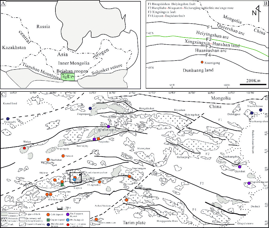
1 IntroductionBeishan lies in the East of the Tianshan orogen (Fig. 1A) and is situated at the intersection of the Kazakhstan and Tarim plates. In Beishan, there are a number of nearly NE-strike trending ophiolite zones and large deep faults (Fig. 1B), from south to north divided into the Dunhuang land-mass, Huaniushan arc, Xingxingxia–Hanshan block, Heiyingshan arc and Queershan arc❶ (Zuo GC and He GQ, 1990). Since the beginning of the Cambrian period, the area had experienced two periods of plate tectonic regimes and two main subduction-collision orogeny events, and multiple periods of tectonic-magmatic evolution cycles (Sun XC et al., 2011), all this having created favorable conditions for metallogenesis. The ductile shearing zones along the NWW—SEE strike within the area control the formation and distribution of Au deposits. The work area is located in the south of Beishan, and in terms of tectonic structure, is situated on the northern margin of the Dunhuang block of the Tarim Plate (Fig. 1), along the Nanliuyuan—Daqishan large deep fault.
|
图 1 Tectonic structure location of Beishan orogene (A), Tectonic unit division in Beishan (B), and Beishan regional geology (C). (A comes from Kröner A et al., 2008; B from Xiao WJ et al., 2010; C from Miao LC et al., 2014) |
Most of the 1∶50 000 regional geological survey in Beishan had been done in the 1980 s to 1990 s, the Huaniushan map sheet regional geological survey was completed in the 1980 s and meanwhile, the 1∶50 000 soil survey, 1∶50 000 magnetic survey and 1∶50 000 heavy mineral survey were also completed. In addition, the tectonic environment and rock characteristics, etc., were well studied in the area (Yin Y and Yin XM, 2010; Yu JY et al., 2015). These early works paved the way for compilation of the Huaniushan map-sheet geological mineral map. As a demonstrative map of the China Geological Survey (CGS) mineral geological survey, the Huaniushan map-sheet 1∶50 000 geological mineral map aims to reflect new results in geological survey, mineral survey and scientific research in the new round of mineral survey. It provides basic geological maps for mineral resource research and energy exploration, etc. in the area, and provides meaningful data for reference for scientific research and field geological survey. The brief metadata sheet of the 1∶50 000 mineral geological map database of the Huaniushan Map-sheet, Gansu, is shown in Table 1.
|
|
表 1 Metadata Table of Database (Dataset) |
The 1∶50 000 mineral geological map database of the Huaniushan map-sheet, Gansu, has been developed basically in accordance with DD 2019-02 Technical Specification for Mineral Geological Survey (1∶50 000), guided by the “trinity” survey area prospecting prediction theory, building on original data and information from the previous 1∶50 000 regional geological survey on Huaniushan map-sheet, Gansu❷ (including original data map, profile and record book) and applying fully new results from this 1∶50 000 mineral geological mapping of the Huaniushan map-sheet. The latest geographical data from the National Survey and Mapping Geographical Information Bureau are used in the geographical base map. Existing technical standards and computer software such as the digital mapping system (DGSS) and MapGIS are applied for data processing.
2.2 Data Processing 2.2.1 Data PreparationCollected regional geological survey results and original data maps were digitalized to generate MapGIS point, line and area files. A 1∶50 000 standard map frame was generated based on the range of the Huaniushan map sheet. The project system is Gauss-Kruger Projection parameters and the coordinate system is Xi’an 80.
2.2.2 Prepare Formation - Structure SketchOriginal data such as measured profile and field route records involved in Huaniushan 1∶50 000 Regional Geological Survey Report❷ were reviewed and analyzed to break down formation-level compilation units and make up lithological (combination) boundary. Field records were expressed in the original data map in the form of points or lines of lithological patterns (Fig. 2).
|
图 2 The 1∶50 000 formation structural map (sketch) of Huaniushan |
(1) Formation
In accordance with the unified color use standard, panels of various colors are used to represent eras of formations, formation patterns are used to represent formation types, appropriate patterns represent rock association and codes are expressed by lithology + era. The lithological lithofacies boundaries are used as boundaries of calcareous rock strata in sedimentary rock formations, and interlayers of marine volcanic rocks. Formations are expressed with appropriate patterns and different colors represent eras.
(2) Vein rock
In accordance with the unified color use standard, colors of panels represent lithologies and their codes are represented by the lithological codes.
(3) Structure
In accordance with the unified color use standard, red alone is used to represent all structures and different line-types represent the nature of faults.
(4) Geological profile
The standard profile line type + profile code are used to represent the location, geological points and their codes are used to represent the actual control points. Appropriate patterns represent lithologies of various strata, whereas occurrences of elements are represented in the geological profiles.
(5) Fossil sampling points
Locations and fossil types are represented in accordance with the unified color use standard + submap style, and a database was created.
(6) Sampling points for rock chemical samples
Standard submap number + sample number are used to represent locations of sampling points and create the database.
(7) Sampling points for geochemical samples
Standard submap number + sample number are used to represent locations of sampling points and create the database.
(8) Sampling points for isotope samples
Standard submap number + sample number are used to represent locations of sampling points and create the database.
2.2.3 Specific Field Geological MappingBy analyzing and collating comprehensively existing information, and compiling formation–structure sketches, focused and general work areas were divided, and it was determined that the specific field geological mapping includes late-Triassic-epoch intrusive rock, mineralized alteration, structure and vein rock, etc. Using the 1∶250 000 original data maps in the digital mapping palmtop as base maps, by surveying along the most practical route in the field, information of points and lines such as geological points, boundary points, geological boundary and route were plotted, information of each point on nature, lithology and occurrence, etc., were observed and registered in the digital mapping system, so that the digital mapping (PRB) database was established initially.
Geological point (P): this includes boundary point and observation point. In the field, it is needed to fill simple properties in the system, including point number, point nature, micro-topography, outcropping, weathered degree, location, mapping unit and contact relation, while coordinate information was read by the system automatically.
Geological route (R): in the field, it is required to fill properties in the system, including route number, geological point number, route code, orientation angle, distance between current work points, accumulative distance, mapping unit and rock name. Of these, the orientation angle, distance of current work and accumulative distance were automatically calculated in the system.
Geological boundary (B): in the field, it is required to fill properties in the system, including route number, geological point number, B code, R code, boundary type, mapping units at the left and right sides, contact relation, strike, dip and dip angle.
For geological occurrences observed throughout the journey and specimens collected, relevant information can be positioned and entered in the system any time, entering property data.
2.2.4 In-house Data Collation(1) Data and information on geological point (P), geological route (R) and geological boundary (B) acquired in the field are imported into a computer and data are collated in accordance with applicable codes.
① Basic requirement on geological point (P) process: information such as route number, weathered degree and contact relation are entered truly and completely, the code of mapping unit are filled accordingly, rock names are consistent with the dialogue box of geological description (including color, texture and structure etc.), information in notes result from thin section authentication and filled after it is comprehensively named as per actual conditions.
② Basic requirement on geological route (R) process: this is done in-house in the process of “smooth curve—modify line parameters (linearity: 1; color: 1; line width: 0)—calculate route between points—(calculate and sum workload)”. R property database is complemented and improved, and orientations and distances are calculated again before describing route geology.
③ Basic requirement on geological boundary (B) process: an in-house computer is used to beautify any geological boundary by cutting lines into shorter lines, extending lines to be longer, and drawing lines again. Parameters such as color, linearity and line width, etc., are unified. Information describing geological boundaries is complemented, “the left side is xxx and the right side is xxx” is used to describe lithologies on both sides of the boundary. It is a default that the left side lithology is observed first and the right side’s is observed later, and the contact relation between the two lithologies and its evidence are described.
④ Requirement on occurrence, sampling and pictures in routes: complement information describing properties such as occurrence and sampling. When arriving at a new geological point the occurrence numbering starts with 1, 2, 3, and so on, and after pictures are imported, geological phenomena reflected in these pictures are described in the detailed description.
(2) Original data maps dominated by PRB data acquired in the field are combined with those original data maps from regional geological survey collated in compilation of the formation–structure sketch, to modify stratigraphic unit boundaries, formation pattern and structural features reflecting various formations, and to draw and connect the boundary of a newly-formed geological unit.
2.2.5 Compile Various Angular Maps(1) Formation histogram: express formation characteristics of rock stratigraphic unit in the master map in detail. By comprehensively analyzing and studying various formations and structures in the map sheet as well as their relation with mineralization, the formation histograms of sedimentary, volcanic, intrusive and metamorphic rocks are plotted respectively.
(2) Typical deposits’angular map: include typical deposit Huaniushan magma-hydrothermal-solution deposit metallogenic element maps and 12-line geological profile maps, providing reference to prospecting prediction in the area. On the strength of the collected previous informationCD and results, by making full use of results from field survey and comprehensive research on typical deposits, the angular maps of typical deposits were compiled.
(3) Secant profile: in the map sheet, the general strikes of formations and structures are NE and EW; to effectively reflect general features of the various formations and structures as well as their relationship with mineralization, two secant profiles, of which one is in the strike of nearly SN and the other is nearly NWW, are arranged throughout the area to control formations of the Nanhua–Sinian strata, later-Devonian and late-Triassic-epoch granite, and Devonian and Ordovician volcanic rocks. Regarding repression modes, the standard profile line type + profile code are used to represent the location, geological points and their codes are used to represent the actual control points; appropriate patterns represent lithologies of various strata, while element occurrences are represented in the geological profiles.
(4) Deposit directory: analyze deposits in the area with respect to deposit name, scale, type, main mineral-bearing formation, etc., to develop a deposit directory, which helps to understand minerals throughout the Huaniushan map sheet.
(5) Metallogenic zone location map: this shows the location of the Huaniushan map sheet in the regional tectonics and its regional geological background (Fig. 3). On the strength of collection of the Gansu 1∶500 000 regional metallogenic regularity map❺, the map is cut based on the regional contour range identified in the map sheet, to reserve metallogenic zones Ⅰ–Ⅳ and the main geographical names and deposits. Then it is zoomed out or in to generate the angular maps of metallogenic zones belonging to the Huaniushan map sheet. The regional contour range must satisfy conditions as follows: A) the work map sheet is the center; B) it shall cover the complete range of regional metallogenic zones for mineral prediction; C) it shall cover the complete range of regional structural zones related to metallogenic zones belonging to the predicted deposit region; D) it shall include the relatively complete range of the metallogenic geological-body rock-control (diagenesis) structural belts related to mineral prediction.
|
图 3 Metallogenic zone location map |
(6) Other angular maps: legends for vein rocks, formations and mineralized alteration are searched to prepare various legends.
3 Description of Data Samples 3.1 Naming Method of DataGeological plane.wp, geological line.wl and geological point.wt.
3.2 Content of Map LayerContents of master maps include formations of sedimentary, volcanic, intrusive and metamorphic rocks; Quaternary; structure; geological boundary; occurrence; deposit location; mineralized alteration; various codes, etc.
The content of angular maps includes: map set, histogram, legend, secant profile, typical deposit metallogenic element diagram, typical deposit measured profile diagram, deposit directory, metallogenic zone location map and responsibility list, etc.
3.3 Data categoryName of entity categories: point, line and area;
Point entity: various geological bodies symbols and marks, geological patterns, deposit locations and mineralized alterations;
Line entity: fault structure, geological boundary and lithofacies boundary, etc.;
Area entity: sedimentary, volcanic, metamorphic and intrusive rocks, and Quaternary, etc.
3.4 Data PropertiesThe 1∶50 000 mineral geological map database of the Huaniushan map-sheet (K46E017023) contains information on geological entity elements, geographical elements and geological map decoration elements. The property of information on geographic elements follows the property structure of data collected by the National Survey & Mapping Geographical Information Bureau. In accordance with the requirements for establishment of the specific geological mapping database for the 1∶50 000 mineral geological survey, database properties are established for information properties of geological entity elements in terms of four categories of rocks (sedimentary, volcanic, intrusive and metamorphic), fault structure, occurrence elements and deposit location, etc.
Properties of sedimentary rock formation data mainly include: chrono-stratigraphic unit, litho-stratigraphic unit, formation name, formation code, lithological combination, stratigraphic age, formation thickness, formation ore-bearing potential, rock texture, sedimentary structure, rock color, sedimentation type, sedimentary facies type, syndepositional structure.
Properties of volcanic rock formation data mainly include: chrono-stratigraphic unit, litho-stratigraphic unit, formation name, formation code, stratigraphic age, stratigraphic division, lithological combination, formation thickness, formation ore-bearing potential, volcano-eruption cycles, volcano-eruption type, volcanic rock genetic type, special lithological interlayer, volcanic lithofacies type and isotopic age.
Properties of intrusive rock formation data mainly include: formation name, formation code, lithological combination, formation ore-bearing potential, rock texture, rock structure, intrusive periods, rock-mass occurrence, planar form, profile form, rock-mass emplacement structure feature, contact zone feature, genetic type and isotopic age.
Properties of metamorphic rock formation data mainly include: chrono-stratigraphic unit, litho-stratigraphic unit, formation name, formation code, lithological combination, stratigraphic age, formation thickness, formation ore-bearing potential, rock texture, rock structure, protolith formation, metamorphic facies and metamorphism type.
Properties of fault structure data mainly include: fault name, type, elongation, extended depth, strike, and fault surface dip and dip angle, fault displacement, fault surface form, tectonite feature, movement mode, activity periods and mechanical properties.
Properties of occurrence data include: occurrence type, dip and dip angle.
Properties of deposit location data mainly include: deposit location number, name and category, traffic location, geographic longitude and latitude, ore species, deposit genetic type, scale, associated (co-existing) minerals and proven resources.
4 Data Quality Control and AssessmentAs for mapping precision, mapping and compilation are combined in accordance with DD 2019-02 Technical Specification for Mineral Geological Survey (1∶50 000), priority areas were mapped focusing on practical measurements while general work areas were compiled focusing on original data contained in the Huaniushan K-46-108-A 1∶50 000 Regional Geological Survey Report❷. Data at geological points were collected based on the principle of fully controlling geological bodies, mineralized alteration zones and critical geological boundary, etc. related to metallogeny. To compile the 1∶50 000 mineral geological map of Huaniushan map-sheet, information and data used involved routes to the total length of 918 km, which includes existing information and data of 593 km routes; 48 km routes for ore spot reconnaissance and inspection, 277 km measured routes (32 routes), 495 geological points, 616 geological boundaries, 188 basic analysis samples, 23 samples for optic thin-section identification, 23 rock samples for total analysis, 10 samples for zircon U-Pb age, 847 pictures and 20 sketches. The overall mapping (compilation) precision meets the specific requirements for 1∶50 000 mineral geological specific mapping.
In general, the maps just display closed geological bodies of which the diameter is greater than 100 m, linear geological bodies of which the width is more than 50 m and the length is more than 250 m, and fault and fold tectonics longer than 250 m. Mineralized alteration tectonic zones and other mineralized geological bodies are shown in the maps, regardless of scale; those with smaller thickness are zoomed in using suitable patterns and symbols or merged to be shown in the maps. For general geological points, the error between their positions marked in the field manual map and their actual positions shall be 25 m at most.
In terms of data quality, the mapping routes are self-checked and mutually checked 100%, and the project team checks 30% randomly, meeting quality management requirements on geological survey projects. In late July 2017, Development and Research Center of China Geological Survey (Mineral Exploration Technical Guidance Center, Ministry of Natural Resources) organized experts to inspect the 2017 mid-term field work in Huaniushan including in-house and site work inspection, and concluded that the quality inspection level was excellent. In mid-September 2017, the project team commissioned experts at Gansu Geological Survey Institute to perform a randomized inspection of the Huaniushan in-house information and data 2017. In early July 2018, Development and Research Center of China Geological Survey (Mineral Exploration Technical Guidance Center, Ministry of Natural Resources) organized experts to inspect and accept the 2017 field work in Huaniushan including in-house and site work inspection, and concluded that the field work passed the inspection and acceptance.
5 Data ValueThe 1∶50 000 mineral geological map of Huaniushan map-sheet (K46E017023), Gansu, is a demonstrative map-sheet of CGS in the new round of mineral geological survey. On the basis of profound research into rock composition and structural tectonics of sedimentary sequences in the map sheet, combining the results from this 1∶50 000 specific geological mapping, in accordance with DD 2019-02 Technical Specification for Mineral Geological Survey (1∶50 000), in the principle of formation division, by comprehensively analyzing and studying formation and tectonics, the sedimentary rock strata are re-divided in the mineral geological map (Table 2), by dividing the Nanhua-Sinian Xichangjing Group, Cambrian Xishuangyingshan Formation and Ordovician Huaniushan Group into 4, 2, and 3 formation types, respectively. Zircon U-Pb dating was carried out on rock masses of different periods, and thus it is concluded that the ages of intrusive rocks in the map sheet include 3 periods: late Ordovician−early Silurian, Devonian and late Triassic (Table 3), creating the evolutionary sequence of the magmatite. All these provide basic data to support geological prospecting in the area, play a leading role in scientific and technical innovation, and improve the ability to promote service resource security in mineral geological survey, social and economic development and building of ecological civilization.
|
|
表 2 Sedimentary rock formation list |
|
|
表 3 Intrusive rock formation list |
(1) The 1∶50 000 mineral geological map of the Huaniushan map-sheet (K46E017023), Gansu, is a demonstrative map-sheet of CGS in the new round of mineral geological survey. The project team created this map by positively exploring and innovating ways to represent specific mineral geological mapping results, playing a demonstrative role in mineral geological survey.
(2) The project team compiled the 1∶50 000 geological mineral map of the Huaniushan map-sheet (K46E017023) and created the spatial database, across the board and systematically, which highlights representation of metallogenic information, for instance: mineralization zone, alteration zone, metallogenic structure and metallogenic structure plane.
(3) Building on the systematic collection of previous information and research results, combining the results from this 1∶50 000 specific geological mapping, in the principle of division of formation units, the sedimentary rock strata have been re-divided into the Nanhua−Sinian Xichangjing Group, Cambrian Xishuangyingshan Formation and Ordovician Huaniushan Group that are divided into 4, 2 and 3 formation types, respectively.
(4) Building on systematic collection of previous information and research results, Zircon U-Pb dating has been carried out on the rock masses of different periods, and thus it is concluded that the ages of intrusive rocks in the map sheet include 3 timespans: late Ordovician−early Silurian, Devonian and late Triassic, creating the evolutionary sequence of the magmatite.
Acknowledgements: The 1∶50 000 mineral geological map of Huaniushan map-sheet, Gansu, is a collective achievement, for which the frontline geological workers have paid many industrious efforts in the field. We hereby extend our sincere and faithful gratitude to a number of geological mineral experts for their industrious guidance given in the process of establishing this mineral geological map database. Susan Turner (Brisbane) assisted with English.
Notes:
❶ Mao Qigui, Tectonic Landscape of Paleozoic-era−early-Mesozoic-era Accretion and Collision in Beishan and Its Neibourhood [D]. Beijing: CAS Geological & Geophysical Institute. 2008.
❷ The 4th Geological Mineral Survey Instituted, Gansu Geological Mineral Survey Development Bureau. Huaniushan K-46-108-A 1∶50 000 Regional Geological Survey Report. 1984.
❸ Crew 106, Gansu Nonferrous Geological Survey Bureau. Metallogenic Element Map and Compilation Instructions: Huaniushan-style Intrusive Rock Mass Pb Deposit, Guazhou City, Gansu Province (internal file). 2009.
❹ The Third Geological Mineral Survey Institute, Gansu Geological Mineral Survey Development Bureau. Au-Ag-Pb-Zn Alternative Resources Survey Report on Huaniushan, Anxi County, Gansu Province. 2011.
❺ Gansu Geological Survey Institute. The 1∶500 000 Regional Metallogenic regularities Map and Compilation Instructions in Gansu (internal file). 2012.
Kröner A, Hegner E, Lehmann B, Heinhorstc J, Wingated MTD, Liue DY, Ermelovf P. 2008. Palaeozoic arc magmatism in the Central Asian Orogenic Belt of Kazakhstan: SHRIMP zircon ages and whole-rock Nd isotopic systematic[J]. Journal of Asian Earth Sciences, 32(2): 118-130. |
Xiao WJ , Mao QG , Windley BF , Han CM, Qu JF, Zhang JE, Ao SJ, Guo QQ, Cleven NR, Lin SF, Shan YH, Li LJ. 2010. Paleozoic multiple accretionary and collisional processes of the Beishan orogenic collage[J]. American Journal of Science, 310(10): 1553-1594. DOI:10.2475/10.2010.12 |
苗来成, 朱明帅, 张福勤. 2014. 北山地区中生代岩浆活动与成矿构造背景分析[J]. 中国地质, 41(4): 1191-1204. |
孙新春, 张雨莲, 高永伟. 2011. 甘蒙北山北带古生代地壳演化与成矿作用[J]. 甘肃地质, 20(2): 45-50. |
殷勇, 殷先明. 2010. 花牛山地区中生代A型花岗岩特征及其找矿意义[J]. 甘肃地质, 19(1): 6-14. |
余吉远, 王国强, 李向民, 计波, 闫巧娟. 2015. 北山地区花牛山群的重新厘定−来自火山岩地球化学证据[J]. 新疆地质, 33(4): 537-543. DOI:10.3969/j.issn.1000-8845.2015.04.022 |
左国朝, 何国琦. 1990. 北山板块构造及成矿规律[M]. 北京: 北京大学出版社.
|
Kröner A, Hegner E, Lehmann B, Heinhorstc J, Wingated MTD, Liue DY, Ermelovf P. 2008. Palaeozoic arc magmatism in the Central Asian Orogenic Belt of Kazakhstan: SHRIMP zircon ages and whole-rock Nd isotopic systematic[J]. Journal of Asian Earth Sciences, 32(2): 118-130. |
Miao Laicheng, Zhu Mingshuai, Zhang Fuqin. 2014. Tectonic setting of Mesozoic magmatism and associated metallogenesis in Beishan area[J]. Geology in China, 41(4): 1191-1204. |
Sun Xinchun, Zhang Yulian, Gao Yongwei. 2011. Paleozolc crustal evolution and mineralization of the northern Beishan in Gansu[J]. Gansu Geology, 20(2): 45-50. |
Xiao WJ, Mao QG, Windley BF, et al. 2010. Paleozoic multiple accretionary and collisional processes of the Beishan orogenic collage[J]. American Journal of Science, 310(10): 1553-1594. |
Yin Yong, Yin Xianming. 2010. Features of mesozoic a-type geanites and it’s significancesfor prospecting in Huaniushan area[J]. Gansu Geology, 19(1): 6-14. |
Yu Jiyuan, Wang Guoqiang, Li Xiangmin, Ji Bo, Yan Qiaojuan. 2015. The Redefinition of Huaniushan Group in Beishan area: Geochemical Evidence from Volcanic Rocks[J]. Xinjiang Geology, 33(4): 537-543. |
Zuo Guochao, He Guoqi. 1990. Beishan plate structure and metallogenic regularity [M].Beijing: Peking University Press (in Chinese).
|


