-
摘要:
奉节县是中国三峡库区地质灾害高发区县,区内地形起伏,构造和软弱岩层发育,地质环境较脆弱,通过对研究区开展野外地质调查,查清了区内地质灾害分布规律及孕灾地质背景,整合灾害、地质和地理信息等数据,首次编制了奉节县幅1:50 000灾害地质图,建立数据集。本文从数据来源、数据收集方法、处理技术等方面进行了整理和归纳,以期呈现地质灾害调查领域灾害地质图数据集应用的实例,为该类型地质调查和数据集处理及应用提供参考。
Abstract:Situated in China's Three Gorges Reservoir Region, the Fengjie County is prone to frequent geo-hazards. This area features big topographic relief, well-developed structures and soft rocks, and relatively fragile geological environment. This paper employs field geological surveys to ascertain the distribution regularities of geo-hazards and geo-hazard breeding geological setting in the studied area. The dataset of geo-hazards in Fengjie Mapsheet (1:50, 000), which has integrated the data in geo-hazard, geology and geography, has been constructed for the first time, along with the compilation of the same-scaled geo-hazard maps of Fengjie County Mapsheet. This paper has also classified the data sources, data collecting methods, and processing techniques, so as to provide practical application case of the geo-hazard maps dataset, and meanwhile present references for the data processing and application in this type of geological survey.
-
1. 引言
奉节县位于重庆东北部,长江三峡库区腹心,境内溪流交错,处四川盆地和盆边山地过渡地带,山峦起伏,地貌以山地和丘陵为主,地势起伏较大,山地面积广。在地层岩性、地质构造、斜坡结构、降雨和人类工程活动的影响下,滑坡、崩塌等地质灾害十分发育,是三峡库区地质灾害高发区县之一。调查区内地质灾害类型以崩塌、滑坡为主,少有泥石流,地面沉降、地裂缝等灾害不发育,本灾害地质图数据集以表达滑坡、崩塌为主。
奉节县幅(H49E006007)为渝东北山区城镇地质灾害调查项目2016年工作图幅之一,地理坐标:109°30′E ~ 109°45′E,31°00′N ~ 31°10′N,主要有草堂镇、白帝镇、永乐镇等集镇,面积约440 km2。地貌以侵蚀中山、中低山地貌和侵蚀丘陵地貌为主,山高坡陡,地形起伏大,最高点高程1 865 m,最低高程为库区江水面(175 m水位),高差达1 690 m。图幅位于八面山弧形构造带核心部位,褶皱构造发育,受地形、构造和软弱地层影响,地质灾害发育。
调查以查清孕灾地质环境背景,掌握控制灾害因子发展规律为目的(王德伟等,2017)。在2016年度调查成果的基础上编制了奉节县幅1:50 000灾害地质图并形成数据集,通过该数据集可直观表达调查区崩塌、滑坡灾害的发育位置以及各灾害地质综合体的孕灾等级程度,对调查区综合防灾减灾工作具有重要意义,数据库(集)基本信息如表 1所示。
表 1 数据库(集)元数据简表
2. 数据采集和处理方法
2.1 数据采集
1:50 000奉节县幅灾害地质图的编制是以2014年4月中国地质调查局发布的《地质灾害调查评价技术要求试用版》(1:50 000)为指导;以2010年2月中国地质环境监测院发布的《1:50 000地质灾害调查信息化成果技术要求》作为灾害地质图数据库的依据。
重庆市已完成全市1:1万地形数据的测量(2006年出版),本图使用地形线数据来源于重庆市地理信息局提供的DWG格式数据。奉节县幅(H49E006007)1:50 000 DLG数据由国家测绘局提供。同时从全国地质资料馆收集1:50 000、1:200 000区域地质调查报告等资料,从重庆市奉节县国土局收集地质灾害排查资料等。这些资料作为1:50 000奉节县幅灾害地质图编制的基础底图数据。
本图幅地质调查工作,采用1:50 000地形图测制,地面调查图件采用1:10 000地形图及公开的遥感影像图。
调查布置的观测路线与观测点的密度根据地质条件的复杂程度、危害对象的重要性以及地质灾害点的密度需要,在重点调查区平均调查点数0.2 ~ 1点/km2。对于地质灾害点较稀少的区段,野外调查视具体情况做地质环境条件控制性定点调查。地质体或灾害地质综合体在1:50 000手图上的直径大于2 mm(面状)或长度大于2 mm(线状)均采用实体勾绘表示出来,不能表示实际面积、形状者,用规定的符号表示。滑坡点定在滑坡后缘中部,崩塌点定在崩塌发生的前沿。本次调查工作共采集滑坡点121个,崩塌点15个,滑坡灾害主要沿长江两岸、草堂河谷发育,崩塌灾害受人工切坡影响较大,主要发育在奉节县幅内主要交通干线两侧。
地质图、构造线资料采用地质图数字化以及实地调查修正。
2.2 数据处理
1:50 000奉节县幅灾害地质图数据及地质图数据处理过程如下。
2.2.1 图件背景底图处理
奉节县幅(H49E006007)涉及1:10 000图幅共20幅,见表 2,图幅的坐标系为西安80坐标系,其中A列数据中央经线108,而B-D列数据中央经线为111。
表 2 奉节县幅涉及1:10 000地形图
本成果图件使用的坐标系为国家2000坐标系(CGCS2000),与购买数据有偏差。根据野外实际调查基准点对比情况,调查图幅内相同调查点在两种坐标系下东西向偏差100米,需要校正完成精度匹配。即选择多个(三个以上)西安80坐标系和2000坐标系下相同的基准点,利用基准点原始公里网格坐标数据,计算出三参数,完成校正。
在使用1:10 000地形图时,需将A列中央经线为108的数据在ArcGIS中利用ArcToolBox- > Data Management Tools- > Projections and Transformations工具进行投影变换至中央经线111,然后将涉及的20幅图拼成在一起。利用ArcGIS生成高精度DEM和山影做背景底图。
2.2.2 灾害地质综合体数据处理方法
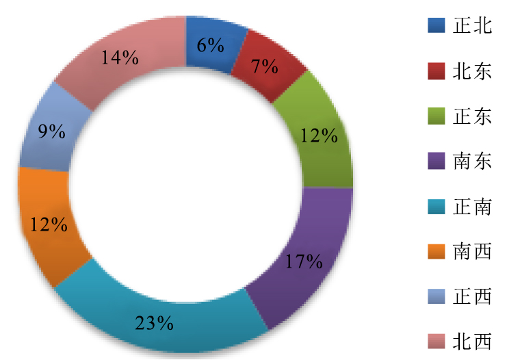
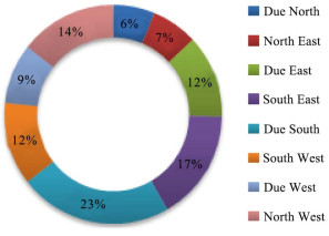
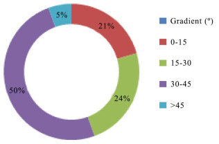
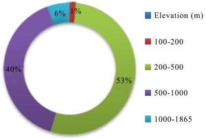
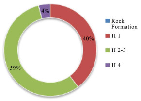
(1)在完成整个图幅调查后,根据图幅调查数据库,统计区内与灾害发育关联性最高的若干地质要素,比如坡向、坡度、高程、工程地质岩组等(图 1—图 4)。
(2)根据地质灾害与诱发灾害发育要素统计的结果,再依据野外调查中对灾害发育的认识,选取关联程度最高的若干要素,1:50 000奉节县幅选取了坡度、高程、工程地质岩组三个相关地质要素。
(3)根据收集的地质资料、钻探资料以及野外调查中地层岩性的工程地质特点,完成图幅灾害地质岩组的划分,共计划分7类灾害地质岩组。
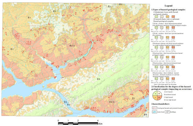
(4)根据与地质灾害发育的地质要素的影响程度,对其赋值,通过统计、叠加、分析等手段,将每个工程地质岩组分成低、中、高、极高四个等级,分别用浅绿、浅黄、橙、红四个谱染色进行表达,每个谱染色结果代表不同类型的灾害地质综合体。奉节县幅分为第四系松散土体灾害地质综合体、层状碎屑岩、碳酸盐灾害地质综合体3个大类,7个小类,如图 5所示。具体赋值方法采用信息量法的易发性评价的方式,利用灾害点或栅格数量作为参量进行评估,针对奉节县幅,利用地质灾害点密度作为参量进行评估,结合地质灾害诱发因素与灾害发育统计饼图,利用信息量法计算公式,对主要影响灾害发育的岩组、坡度、高程按照饼图分级分类并进行计算各区间的信息量值,下一步对栅格叠加分析,然后划分四个等级灾害地质综合体。

其中,P(B/Aj)——对应成灾要素A中第j区间的地质灾害B的发生概率;
P(B)——地质灾害B发生概率的区域背景值;
IAj→B——地质灾害信息量值,单位:Nat;
n——成灾要素A被划分为的次级区间数。
2.3 灾害地质综合体孕灾程度分布特征
通过叠加计算,形成奉节县幅灾害地质图(图 5),可初步分析奉节县个灾害地质综合体孕灾程度极高、高、中、低的分布范围,可为奉节县的地质灾害防治提供基础依据。孕灾程度分级的地点及特征如表 3所示:
表 3 奉节县幅灾害地质孕灾程度等级分布及特征一览表
3. 数据样本描述
3.1 图层名称
地质图和地理底图图层主要按要素类型划分,分别为:GA20H49E006007(地质灾害综合体)、GA10H49E006007(灾害地质岩组界线)、ZA00H49E006007(滑坡特征点)、ZA20H49E006007(滑坡特征面)、ZA10H49E006007(滑坡特征线)、ZB00H49E006007(崩塌特征点)、ZB10H49E006007(崩塌特征面)、DA10H49E006007(构造线)、LB2049E006007(水系),以文件的形式存放在File Geodatabase(H49E006007GD.gdb)内。
3.2 图层编号
图层编号为3位或4为字符组成,其中基本地理类图层编号参照国家测绘局数字线划地图数据分层及命名规则。本数据集图层编号采用4位字符,详见表 4;除基本地理类图层外的专业图层,图层编号由图类代码和图层代码组成,图层编号为位字符,详见表 5。
表 4 基本地理数据分层及命名 表 5 地质相关专业图层编号
3.3 图幅编号
图幅编号采用1:50 000标准图幅号,由10位字符组成。如本图幅为H49E006007。
3.4 要素类型名称
实体类型点名称:滑坡点、崩塌点;线实体:滑坡灾害特征线、灾害地质岩组界线、构造线等;面实体:综合地质体、滑坡体、崩塌体等。
3.5 属性列表
ArcGIS中每个图层都需要有相对应的文件和属性表,文件一般分为点文件、线文件和面文件,属性表分为灾害类属性表、地质类属性表(表 6)。灾害类属性表分为滑坡灾害属性表和崩塌灾害属性表。地质类属性表主要为综合地质体面属性表。
表 6 灾害地质数据库图层属性
4. 数据质量控制和评估
在图幅内设立控制点。对图幅内重点调查区勘察点、测绘点采用全站仪按照国家测量规范要求进行测量,精度可以满足调查需求。各类调查点定位使用手持GPS CGCS2000坐标系统读数、地物信息与地形图图面信息三者对应,保证调查点位满足1:5 000地质灾害调查精度。
5. 数据库质量保证措施
数据库与野外采集终端配套,可以在野外数据采集后将数据直接导入数据库中,为保证编图图层要素所赋属性内容、结构等完整、准确,在采集端数据录入时采用三级校验,入库后进行逐一核实检查。检查内容包括调查数据点、线、面是否在调查图幅内,检查属性表是否完整,描述是否准确。建库过程中,定期自检、互检以及抽检,确保数据库中数据的准确性。
6. 数据应用前景
该数据库有广泛的应用前景,可作为编制各种同比例尺地质灾害评价图系的基础地质信息库,为地方防灾害减灾工作提供基础数据支撑。本数据库采用ArcGIS通用格式建立,内容丰富、查询方便、可编辑性强,可与同类型数据实现叠加、合并与再处理,便于数据库的管理与信息共享。
7. 结论
奉节县幅灾害地质图数据集包括:“灾害地质综合地质体数据表”、“滑坡灾害数据表”、“崩塌灾害数据表”、“灾害地质岩组界线数据表”、“地质构造线数据表”。该数据集对奉节县幅地质灾害风险评价与地质灾害防治规划具有指导意义,可为同类评价工作和灾害地质图件的编制提供参考。
1. Introduction
Located in northeast of Chongqing, Fengjie County is a vital part of the Three Gorges Reservoir Region along the Yangtze River. Dotted with interlacing streams, Fengjie County is situated in the transitional zone of Sichuan Basin, with mountain land on the side of the basin. It features undulating hills, rising and falling terrain, and a large area of mountain land. Its landform is dominated by mountain lands and hills. Under the impact of formation lithology, geological structure, slope structure, rainfall and human engineering activities, landslide and other geological hazards are frequent in Fengjie County. It is prone to geological hazards in the Three Gorges Reservoir Region.
Fengjie County Mapsheet (H49E006007) is one of the target mapsheets of the geo-hazard survey in the urbanized northeastern mountainous areas of Chongqing in 2016. Spreading over an area of 440 km2, and primarily covering Caotang Town, Baidi Town, and Yongle Town, its geographic coordinates are within 109°30′E-109°45′E and 31°00′N-31°10′N. The landform is dominated by eroded mid- and mid-to-low height mountains, and eroded hills. The topography features high cliffs and steep slopes with obvious vertical reliefs. The peak elevation is 1, 865m, and the lowest is the water surface (175 m water level) of the reservoir, with a height margin of 1, 690 m. The mapsheet is located in the core part of Bamianshan arc-shaped tectonic zone, where is profoundly influenced by the landforms, tectonics and soft strata, and has well developed folding structures and geo-hazards.
The survey aims to ascertain hazard-inducing geological settings, and grasp the regularities of development of controlling hazard factor (Wang Dewei et al., 2017). Dataset of Geo-Hazards in Fengjie Mapsheet (1:50, 000) has been compiled on the basis of 2016 survey results. It is significant for comprehensive disaster prevention and reduction in the survey area. Refer to Table 1 for basic information of the dataset.
Table 1. Metadata table of Database (Dataset)
2. Data Acquisition and Processing Methods
2.1 Data Acquisition
Dataset of Geo-Hazards in Fengjie Mapsheet (1:50, 000) has been compiled under the guidance of the Trial Version of Technical Requirements for Survey and Evaluation of Geological Hazards (1:50, 000) published by China Geological Survey in April 2014. Meanwhile, the Technical Requirements for Information-based Results of 1:50, 000 geo-hazard Survey published by China Institute of Geological Environment Monitoring in February 2010 acts as the basis for the geo-hazard map dataset.
Chongqing has completed the measurement of 1:10, 000 topographic data (published in 2006) of the entire city. The form line data used in this map come from DWG format data provided by Chongqing Bureau of Geographic Information. Meanwhile, 1:50, 000 DLG data of Mapsheet of Fengjie County (H49E006007) are provided by the National Administration of Surveying and Mapping. At the same time, 1:50, 000, 1:200, 000 regional geological survey reports and other data have been collected from the National Geological Archives of China, while the geo-hazard hunt data have been collected from Fengjie Bureau of Land and Resources of Chongqing. These data are regarded as the basic base map data for the compilation of Dataset of Geo-Hazards in Fengjie Mapsheet (1:50, 000).
Surveying and mapping by 1:50, 000 topographic maps have been adopted for carrying out geological survey for this mapsheet. In addition, the ground survey map adopts 1:10, 000 topographic map and open remote sensing image map.
The arrangements of the observation routes and the density of observation points in the survey are considered according to the complexity of geological conditions, importance of the threatened objects, and the density of the geo-hazard points; the average number of survey point in the focused area is 0.2-1 points/km2. In the area with much less geo-hazard points, the qualitative controlling point surveys on geological environmental conditions have been accordingly designated. On the 1:50, 000 scaled hand map, for the geological body or geo-hazard complex, if the diameter is bigger than 2mm (planar geo-hazard) or the length is larger than 2mm (linear geo-hazard), they are shown by real-scale entity delineation. If the actual sizes of the area or shape cannot be drawn, the specified symbols are adopted. Meanwhile, the landslide point is drawn in the middle of real landslide’s rear edge, and the collapse point is drawn at the front edge of the real collapse. In this survey, 121 landslide points and 15 collapse points have been collected in total.
Moreover, the geological map and structural line data have been digitalized by using geological maps. They have also been corrected according to the field survey.
2.2 Data Processing
The data processing for Dataset of Geo-Hazards in Fengjie Mapsheet (1:50, 000) and geological map is as follows:
2.2.1 Processing of Background Base Map
Mapsheet of Fengjie County (H49E006007) involves about 20 1:10, 000 mapsheets (see Table 2). The mapsheet uses Xi’an 80 Coordinate System. The central meridian of Row A data is 108 and the central meridian of Rows B-D data is 111.
Table 2. Topographical Map Involved in 1:10, 000 Fengjie Mapsheet
The coordinate system used in this result map is China Geodetic Coordinate System 2000 (CGCS2000), which has a deviation from the purchased data. According to the comparisons among the datum points of on-the-spot surveys, a certain assigned surveyed point has 100m deviation along the east-west direction as shown in the two different coordinate systems. Therefore, correction is to be done so as to ensure the precision coordination. In other words, multiple (more than three) datum points should be respectively selected in both the Xi’an 80 Coordinate System and the CGCS2000, and three parameters for the correction should be calculated out through the coordinate data of the original kilometer grid of datum points.
When 1:10, 000 topographic map was used in ArcGIS (ArcToolBox > Data Management Tools > Projections and Transformations Tools), the data whose central meridian was 108 in Row A should be projected and transformed into the central meridian of 111. Then, 20 maps involved were pieced together. By virtue of ArcGIS, high precision DEM and mountain shade were generated, which acted as the background base map.
2.2.2 Data Processing Method of Geo-hazard Complex
(1) After the completion of mapsheet survey, according to the mapsheet survey dataset, several geological elements, which have the highest relevance to the hazard development in the area, were calculated, such as slope direction, gradient, elevation, and engineering geological rock formation (see Figs. 1 to 4).
(2) Several elements with the highest relevance were selected according to the statistical results of geological hazards and induced hazard development elements and in line with the understanding of hazard development in the field survey. In 1:50, 000 Mapsheet of Fengjie County, gradient, elevation, and engineering geological rock formation were selected as three related geological elements.
(3) Pursuant to the collected geological data and drilling data, as well as engineering geological features of formation lithology in the field survey, the geo-hazard rock formation of mapsheet has been divided into seven geo-hazard rock formations.
(4) Different values are respectively given to the different rock formations according to the influences of their geological factors exerted to the geo-hazards. By statistics, overlaying, analysis and other means, each geo-engineering rock formation has been divided into low, medium, high and extremely high grades, and they are expressed by light green, light yellow, orange and red (4 spectrum colorings), respectively. Each spectrum coloring represents a specific type of geo-hazard complexes. Moreover, Fengjie Mapsheet has been divided into such 2 geo-hazard complexes as: (1) Quaternary loose earths, (2) layered clastic rocks, and (3) carbonate rocks (3 categories and 7 subcategories, as shown in Fig. 5). The concrete value-giving method adopts the proneness evaluation mode of information volume method. The assessment was made by using geo-hazard point or grid quantity as the parameter. As far as Fengjie Mapsheet is concerned, the assessment was made by using the geo-hazard point density as the parameter. Based on the statistical pie chart of geo-hazard breeding factor and geo-hazard development, and by virtue of the calculation formula of information volume method, the rock formation, gradient and elevation that primarily affect the geo-hazard development are graded and classified per pie chart; meanwhile, the information volume values of different zones are calculated. In the next step, the grid overlaying analysis is done. And the four-graded scheme of geo-hazard complexes are then divided.
2.3 Distribution and Characteristics of Hazard Breeding Grades of Geo-hazard Complexes
Geo-Hazards in Fengjie Mapsheet (Fig. 5) is formed through overlaying calculation. Based on this map, we can roughly analyze the distribution of high, medium and low hazard breeding grades of various geo-hazard complexes in Fengjie County so as to provide a fundamental basis for prevention of geological hazards in Fengjie County. The distribution locations and characteristics of hazard breeding grades are shown in Table 3 below.
Table 3. Distribution and characteristics of Geo-hazard breeding grades on Fengjia Mapsheet
3. Description of Data Samples
3.1 Layer Name
The geological map and geographic base map layers have been mainly divided per element type: GA20H49E006007 (Geo-hazard Complex), GA10H49E006007 (Rock Formation’s Boundary of Geo-hazard), ZA00H49E006007 (Landslide Characteristic Point), ZA20H49E006007 (Landslide Characteristic Plane), ZA10H49E006007 (Landslide Characteristic Line), ZB00H49E006007 (Collapse Characteristic Point), ZB10H49E006007 (Collapse Characteristic Plane), DA10H49E006007 (Structural Line), and LB2049E006007 (Water System). They have been stored in File Geodataset (H49E006007GD.gdb) in the form of a file.
3.2 Layer Number
The layer number is composed of three or four characters. The basic geographic layer number is subject to the data layering and naming rules of digital line graphic map of the National Administration of Surveying and Mapping. The layer number of this dataset adopts 4 characters (see Table 4 for details). The layer number of professional layer, except the basic geographic layer, is composed of the map category code and layer code, and the layer number is character(s) (see Table 5 for details).
Table 4. Layering and Naming of Basic Geographic Data Table 5. Related Geological Professional Layer Number
3.3 Mapsheet Number
The mapsheet number adopts 1:50, 000 standard mapsheet number. It is composed of 10 characters. For example, this mapsheet number is is H49E006007.
3.4 Element Type Name
It includes name of entity type point (landslide point and collapse point); line entity (landslide hazard characteristic line, rock formation’s boundary of geo-hazard, structural line and so on); and plane entity (comprehensive geological body, landslide body, collapse body and so on).
3.5 Attribute List
In ArcGIS, each layer should have the corresponding file and attribute list. Generally, the files have been divided as point file, line file and plane file. The attribute lists have been divided into the geo-hazard attribute list and geological attribute list (see Table 6). The geo-hazard attribute list has been divided as Landslide Hazard Attribute List and Collapse Hazard Attribute List. Meanwhile, the geological attribute list is mainly the plane attribute list of comprehensive geological body.
Table 6. Layer Attribute of Geo-hazard Dataset
4. Data Quality Control and Evaluation
The control point has been set up in the mapsheet. The reconnaissance point and surveying and mapping point of major survey area in the mapsheet have been measured by the total station, subject to the national measurement standard requirements. In addition, it meets the precision requirements of the survey. Moreover, for the positioning of all kinds of survey points, the handheld GPS CGCS2000 coordinate system reading, ground object information, and topographic map surface information have been used to guarantee that the survey point location meets 1:50, 000 geo-hazard survey precision.
5. Measures for Dataset Quality
This dataset is linked to the field capturing terminals; the field data can be directly transferred into the dataset after capturing. To guarantee the integrity and accuracy of the assigned attribute content and structure of map-compiling layers, the research team adopted a three-graded calibrating-checking methodology during the datum-inputting process in the capturing terminals; moreover, the data are one by one verified and checked for the second time after being putting into the dataset. The second-round checking covers whether the point, line and plane of the survey data are in the mapsheet, whether the attribute lists are integral, and whether the descriptions are accurate. In the dataset constructing process, regular self-inspections, reciprocal inspections and spot-checks are conducted so as to ensure the data accuracy in the dataset.
6. Data Application Perspectives
This dataset has extensive application perspectives. It may act as a primary geological information base for the compilation of various kinds of geo-hazard evaluation map series; meanwhile, it provides a fundamental data support for the local geo-hazard prevention and mitigation. This dataset has been constructed in basic-format ArcGIS with abundant contents and convenient access, and being quite flexible in editing; it could be easily overlain, combined, and re-processed with other datasets of the same type, providing an easy way for management and data-sharing.
7. Conclusion
The main contents of the Dataset of Geo-Hazards in Fengjie Mapsheet (1:50, 000) includes “Table of Geo-hazard Complexes Data”, “Table of Landslide Geo-hazard Data”, “Table of Collapse Geo-hazard Data”, “Table of Geo-hazard Rock Formation’s Boundaries Data”, and “Table of Geo-tectonic Lineation Data”. This dataset will be a guide for geo-hazard assessment and geo-hazard prevention and control planning in the Fengjie Mapsheet; furthermore, it will provide references for the geo-hazard assessment of the same kind in the other places and will help to compile the geo-hazard maps.
-
表 1 数据库(集)元数据简表

表 2 奉节县幅涉及1:10 000地形图

表 3 奉节县幅灾害地质孕灾程度等级分布及特征一览表

表 4 基本地理数据分层及命名

表 5 地质相关专业图层编号

表 6 灾害地质数据库图层属性

Table 1 Metadata table of Database (Dataset)

Table 2 Topographical Map Involved in 1:10, 000 Fengjie Mapsheet

Table 3 Distribution and characteristics of Geo-hazard breeding grades on Fengjia Mapsheet

Table 4 Layering and Naming of Basic Geographic Data

Table 5 Related Geological Professional Layer Number

Table 6 Layer Attribute of Geo-hazard Dataset

-
刘守全, 刘锡清, 王圣洁, 郭玉贵. 2002.编制1:200万南海灾害地质图的若干问题[J].中国地质灾害与防治学报, 13(1), 17-20. http://d.old.wanfangdata.com.cn/Periodical/xxsfgdzkxxxb201605008 马智民, 王成善, 陈洪德, 田景春. 2005.数字地质图及其关系数据模型研究[J].成都理工大学学报(自然科学版), 32(2), 200-207. http://d.old.wanfangdata.com.cn/Periodical/cdlgxyxb200502018 王德伟, 倪化勇, 陈绪钰, 唐业旗. 2017. 2010年四川省雅江县地质灾害调查数据集[J].中国地质, 44(S1):82-87. http://geochina.cgs.gov.cn/ch/reader/view_abstract.aspx?file_no=2017S110&flag=1 中华人民共和国自然资源部, 灾害地质调查规范(1: 50 000)(征求意见稿), 2018.3. Liu Shouquan, Liu Xiqing, Wang shengjie, Guo Yugui. 2002. Discussion on Some Problems in Compilation of Hazardous Geological Map (1:2, 000, 000) of South China Sea[J].The Chinese of Geological Hazard and Control, 13(1), 17-20 (in Chinese with English abstract). http://d.old.wanfangdata.com.cn/Periodical/xxsfgdzkxxxb201605008
Ma zhimin, Wang Chengshan, Chen Hongde, Tian Jingchun. 2005. Study on digital geologic map and relational data model[J]. Journal of Chengdu University of Technology (Science & Technology Edition), 32(2), 200-207 (in Chinese with English abstract). http://www.wanfangdata.com.cn/details/detail.do?_type=perio&id=cdlgxyxb200502018
Wang Dewei, Ni Huayong, Chen Xuyu, Tang Yeqi. 2017. Dataset of geological hazards survey in Yajiang County, Sichuan Province in 2010[J]. Geology in China, 44(S1):100-107 http://geochina.cgs.gov.cn/ch/reader/view_abstract.aspx?file_no=2017S110&flag=1
Ministry of Natural Resources of the People's Republic of China, Geological disaster survey specifications(1: 50, 000) (Consultation draft), 2018.03 (in Chinese).
-
期刊类型引用(1)
1. 朱庆,张曼迪,丁雨淋,曾浩炜,王玮,刘飞. 环境因子空间特征约束的区域滑坡敏感性模糊逻辑分析方法. 武汉大学学报(信息科学版). 2021(10): 1431-1440 .  百度学术
百度学术
其他类型引用(3)


 下载:
下载:
