A study of flow path in Yuquanshan area of western Beijing based on integrated geophysical technology
-
摘要:
为研究北京西郊玉泉山地区岩溶水径流路径,需查明区内地层结构和断裂构造发育情况,故在玉泉山周边地区开展了综合地球物理勘查工作。完成1:25000面积性重力测量3670点,在重力数据解释推断成果基础上,有针对性地布设可控源音频大地电磁测深(CSAMT)剖面测量5.1 km及微动测深点4个。综合研究了基岩起伏形态和构造展布特征,新解释推断了10条可能存在的断裂构造。结合区域水文地质资料,对主要断裂的水文地质意义进行了分析,形成了玉泉山地区岩溶水强径流路径新的认识,部分成果与最新的同位素水化学研究成果一致。本研究为玉泉山泉恢复确定合理的回灌方案提供了地球物理依据。
Abstract:In order to investigate the features of strata configuration and fault structure and study the karst water flow path in Yuquanshan area of western Beijing, the authors carried out integrated geophysical survey in the surrounding area of Yuquanshan and completed regional gravity survey 107 km2 in area with 3670 measurement points. On the basis of the explanation of gravity anomaly, 5.1km controlled source audio-frequency magnetotellurics (CSAMT) profiles and 4 microtremor measurement points were carried out. According to these geophysical data, the basement relief and structure distribution were comprehensively studied, and 10 possible faults were interpreted and deduced. Combined with regional hydrogeological data, the hydrogeological significance of the main faults was studied. Then a new understanding of the strong karst water flow path in Yuquanshan area was obtained, which is consistent with the result of the latest isotope and hydrochemistry studies. This study provides the geophysical support for determining a reasonable recharge program for the restoration of Yuquanshan spring.
-
Keywords:
- gravity anomaly /
- microtremor survey /
- flow path /
- Yuquanshan /
- integrated geophysics
-
1. 引言
西郊玉泉山地区是北京市重要的地下水供水水源地。随着城市规模的迅速扩张,北京西郊地区从20世纪70年代开始,地下水长期处于过量开采状态,部分含水层出现局部疏干现象,引发地面沉降、水质恶化等环境地质问题。故亟需通过合理回灌等方式回补地下水,使地下水位逐步回升,缓解由地下水过量开采引起的各种环境地质问题(王强等, 1998; 王晓红等, 2011;梁永平等, 2015;吴乐等, 2016; 赵春红等, 2017)。能否成功实现地下水水位回升的关键在于是否有合适的径流路径,而径流路径受地层结构和断裂构造影响,因此,通过综合地球物理分析,查明研究区构造展布特征,可以为岩溶水径流通道分析提供地球物理依据,进而为地下水战略储备工作提供基础资料。
地下水径流路径的研究目前多依靠同位素水化学资料,从宏观上分析水的来源及循环条件,无法对强径流路径进行准确定位(马致远等, 2006; 武倩倩等, 2008; 孙林华等, 2009; 蔡月梅等, 2016; 孙厚云等, 2018)。而本次通过综合地球物理方法技术,对区内地层结构和构造发育特征展开了系统调查,从而直接提供岩溶水强径流路径信息。按照由面到线再到点的研究思路,首先开展1:25000面积性重力工作,基于场源边缘探测技术新勾画断裂构造的平面展布形态,在此基础上于重点构造部位布设CSAMT剖面测量和微动测深点,确定主要地层结构和断裂构造的几何特征。再结合区内已有的钻探、水文地质、地球物理及地球化学等成果资料,对主要断裂的水文地质意义进行初步分析,形成玉泉山地区岩溶水径流路径新的认识。本次研究部分成果与最新的同位素水化学研究成果一致,取得了较好的应用效果。
2. 地质背景
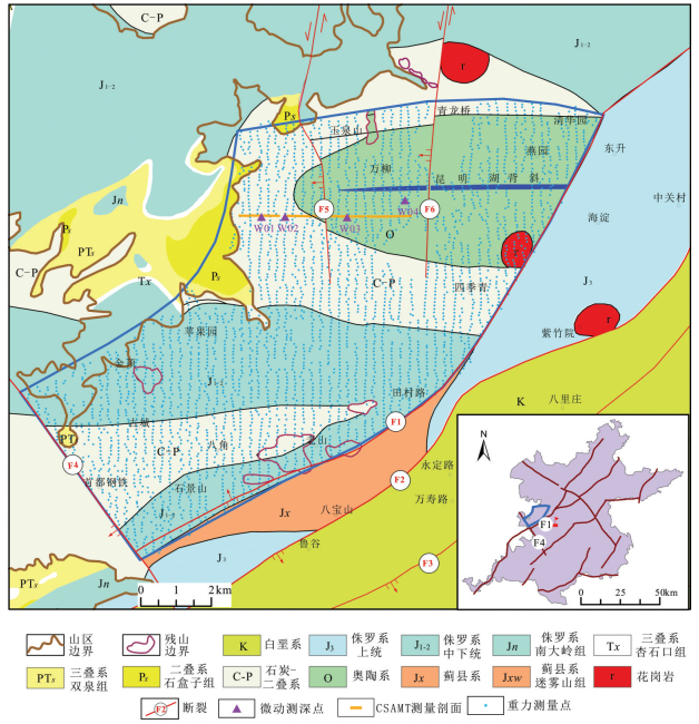
研究区属华北地层大区晋冀鲁豫地层区的燕辽地层分区和华北平原地层分区(图 1)。大地构造位于华北板块燕山褶皱带西山褶皱带内的门头沟迭陷褶的中东部。主要地层有蓟县系(Jx)、奥陶系(O)、石炭—二叠系(C—P)、侏罗系(J)和第四系覆盖层。主要断裂构造有八宝山断裂、冷泉村断裂和西北旺断裂。八宝山断裂南起涞水县城西北,止于海淀镇附近,呈波状弯曲展布于北京山麓和山前平原地带,总体走向NNE至NE,倾向SE,倾角35°~ 45°,断裂总长约90 km;冷泉村断裂出露于海淀区北部山区,属西山褶皱带,走向近SN,长度约17 km,属走滑断层,切割九龙山向斜及昆明湖背斜;西北旺断裂位于四季青—百望山一带,走向近SN,长度约10 km,属走滑断层,切割昆明湖背斜。主要褶皱构造昆明湖背斜属西山褶皱带内的斜河涧—颐和园褶皱构造带,其向东延伸进入平原区,主要由奥陶系及石炭—二叠系组成。背斜轴向近EW,核部为奥陶系,多眼钻孔揭露奥陶系埋深在200~300 m;两翼为石炭—二叠系,多眼钻孔揭露石炭—二叠系埋深一般在100~200 m。背斜东段被北东向的八宝山断裂切断(王强等, 1998)。
研究区地层物性特征详见表 1,数据综合参考了北京市地质勘察技术院1987年完成的“北京平原区北7幅1:50000电测深”和2015年完成的“北京地区岩石密度和磁化率测试”项目成果资料。由表 1可知,第四系为区内明显的低密度层;中生界为中间过渡层位,侏罗系密度平均值为2.57 g/cm3,三叠系多为砂岩或凝灰质砂岩,故密度平均值较高,为2.70 g/cm3;古生界、元古界密度平均值多在2.6~2.8 g/cm3。研究区周边花岗岩的平均密度在2.56~2.76 g/cm3。各地层之间均存在一定程度的密度差异,具备开展重力测量的前提条件。另外,本区蓟县系、寒武系和奥陶系的碳酸盐岩及周边中酸性花岗岩、白岗岩等侵入体呈高阻反映,电阻率常见值为500~ 1000 Ω·m;青白口系(砂页岩夹碳酸盐岩)、侏罗系(安山岩、火山碎屑岩类)呈中阻反映,电阻率常见值为100~500 Ω·m;石炭—二叠系和侏罗系砂页岩煤系地层及第四系呈低阻反映,电阻率常见值为值为100~500 Ω·m;石炭—二叠系和侏罗系砂页岩煤系地层及第四系呈低阻反映,电阻率常见值为10~100 Ω·m。10~100 Ω·m。
表 1 研究区地层物性特征统计Table 1. Statistics of petrophysical properties of strata in the study area
3. 方法和数据
研究区地表建筑密集,电磁和人文干扰较严重,为地球物理工作开展带来巨大挑战。为实现地质勘探目标,需要因地制宜选择合适的方法组合,尽量避免人文干扰造成的虚假异常,降低解释推断的不确定性。故本次遵循由面到线再到点,循序渐进地研究思路,先开展大比例尺面积性重力测量,研究总体地质构造平面展布形态。在此基础上,有针对性地开展CSAMT剖面测量和微动测深单点测量,探测地层垂向结构。最后结合以往水文地质和钻孔等资料,研究断裂等构造的水文地质意义,推断研究区有利于岩溶水运移的径流通道。
3.1 重力数据
鉴于研究区建筑较多,本次采用规则网与自由网相结合的方式进行测点布设。在条件允许的情况下,按照250×100 m南北向布设测网。在建筑物影响较大区域则采用自由网,适当避让,保证测点密度平均为30点/km2。具体测量点展布情况见图 1,除昆明湖水域等个别区域,基本实现了全区均匀覆盖。参与测量的CG-5型重力仪进行了一致性、动态及静态等试验。测地工作利用基于全球卫星定位测绘服务系统(CORS)建立的GPS控制网,通过RTK方式进行三维定位。本次共采集重力数据3670点,重力观测总均方误差为±0.016×10⁻⁵m/s2,精度较高。
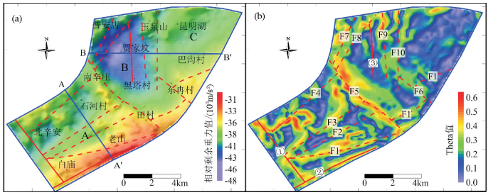
首先对数据进行各项重力场改正,再进行数据网格化和异常光滑等处理,包括利用已有周边重力调查成果资料,对原始数据进行一定范围的扩充,以减少边界效应;选择Kriging插值和八方位搜索进行网格化;对原始异常进行低通滤波,以消除由随机观测误差和各项改正计算误差等引起的高频干扰成分。由于区域重力场主要反映深部信息,剩余重力异常则反映浅部信息(程东兴等, 2011; 董健等, 2018),为了从平面上突出显示断裂等线性构造异常特征,本次采用向上延拓的方式求取区域场,再用布格重力异常减去区域场数据得到重力剩余异常。且因为重力场边缘检测技术具有较好的抗躁性、对弱异常识别性更高和边界连续性好等优点(朱黎明等, 2012; 严加永等, 2015),本次在剩余重力异常的基础上进行了位场水平导数和重力场源边缘检测等异常提取计算。
除此之外,为进行垂向地层分析,形成了2条2D反演剖面,位置见图 2a。2D密度界面反演,需结合钻孔资料,给定地层密度,通过迭代反演,得到目的层界面深度(冯娟等, 2014)。本次反演的初始模型,参考了已知钻孔分层数据(孔位见图 3、图 4)和北京市平原区基岩立体地质调查成果报告中的各地层平均厚度,密度参数参考表 1。基于初始模型,利用RGIS软件进行2D反演,反演数据与实际测量数据间的均方误差分别为:AA'剖面约为±0.070× 10⁻⁵ m/s2,BB'剖面约为±0.095×10-5m/s2,精度较高。
![]() 图 3 AA'剖面综合分析图(平面位置见图 2a)a—正演计算布格重力异常(红线)与实际测量布格重力异常(蓝线)对比关系;b—重力反演解释推断的地质剖面(D为重力反演得到的地层密度,单位:g/cm3)Figure 3. Comprehensive analysis diagram of AA' sectiona-Bouguer gravity anomaly comparison chart between data calculated by forward modelling (red line) and actually surveyed (blue line); b-Geological profile inferred by gravity inversion results (D is density calculated by gravity inversion, Unit: g/cm3)
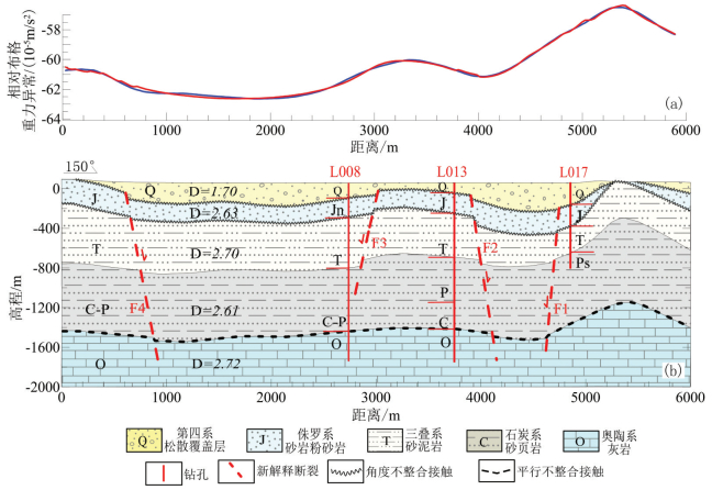
图 3 AA'剖面综合分析图(平面位置见图 2a)a—正演计算布格重力异常(红线)与实际测量布格重力异常(蓝线)对比关系;b—重力反演解释推断的地质剖面(D为重力反演得到的地层密度,单位:g/cm3)Figure 3. Comprehensive analysis diagram of AA' sectiona-Bouguer gravity anomaly comparison chart between data calculated by forward modelling (red line) and actually surveyed (blue line); b-Geological profile inferred by gravity inversion results (D is density calculated by gravity inversion, Unit: g/cm3)![]() 图 4 BB'剖面综合分析图(平面位置见图 2a)a—基于 Kriging插值得到的微动测深视 S波速度剖面;b—CSAMT反演视电阻率等值线断面图;c—正演计算布格重力异常(红线)与实际测量布格重力异常(蓝线)对比关系;d—基于重力反演模型综合解释推断的地质剖面(D为重力反演得到的地层密度,单位:g/cm3)Figure 4. Comprehensive analysis diagram of BB'sectiona-S-wave apparent velocity profile obtained by interpolating microtremor survey data; b-Apparent resistivity section from CSAMT inversion data; c-Bouguer gravity anomaly comparison chart between data calculated by forward modelling (red line) and actually surveyed (blue line); d-Geological profile inferred by gravity inversion results (D is density calculated by gravity inversion, Unit: g/cm3)
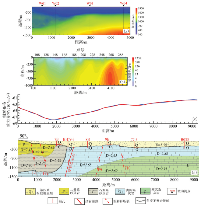
图 4 BB'剖面综合分析图(平面位置见图 2a)a—基于 Kriging插值得到的微动测深视 S波速度剖面;b—CSAMT反演视电阻率等值线断面图;c—正演计算布格重力异常(红线)与实际测量布格重力异常(蓝线)对比关系;d—基于重力反演模型综合解释推断的地质剖面(D为重力反演得到的地层密度,单位:g/cm3)Figure 4. Comprehensive analysis diagram of BB'sectiona-S-wave apparent velocity profile obtained by interpolating microtremor survey data; b-Apparent resistivity section from CSAMT inversion data; c-Bouguer gravity anomaly comparison chart between data calculated by forward modelling (red line) and actually surveyed (blue line); d-Geological profile inferred by gravity inversion results (D is density calculated by gravity inversion, Unit: g/cm3)3.2 CSAMT数据
CSAMT法是以有限长接地电偶极为场源,在距偶极中心一定距离处同时观测电、磁场参数的一种电磁测深方法(吴璐苹等, 1996; 徐光辉等, 2005)。为调查区内目标异常的垂向特征,形成综合剖面,本次过重力低异常区(图 1,图 2a)布设了一条CSAMT测线,采用50 m点距,共测量102个物理点。测点全部合格,一级品率为65%。由于环境噪音的影响,原始数据少部分点存在明显的畸变,根据原始卡尼亚电阻率曲线和阻抗相位曲线趋势特征,结合采集环境,剔除了干扰大的、噪声强的数据。而受高压线等干扰的磁信号,则利用相邻没有干扰的测站磁信号计算视电阻率,通过插值法进行磁信号恢复。经过以上预处理后,进行2D反演,常用的反演方法有最小二乘法、有限元、有限差分等(王若和王妙月, 2003; 曹创华等, 2013; 谭捍东等, 2013; 李静和等, 2018)。本次利用Bostick构建初始模型,TM极化模式,模型平滑系数1.1,利用SCS2D软件,基于有限元算法,以阻抗电阻率和阻抗相位联合反演电阻率参数,并在此基础上进行地质解释推断。
3.3 微动测深数据
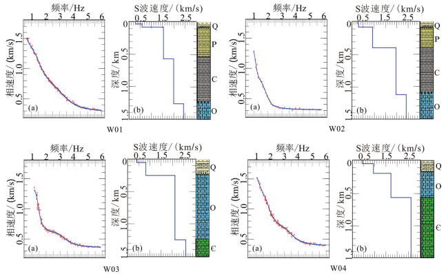
微动测深是基于Rayleigh面波在传播过程中存在频散现象发展起来的。通过合理布设采集阵列,可以采集到自然界中由于气象变化、潮水涨落、人文活动等产生的微动信号,再利用各种处理手段从原始信号中提取瑞雷波相速度频散曲线,结合已有地质和地球物理资料,建立初始模型,由相速度频散曲线反演地下S波速度结构。频散曲线提取手段有多种,常用的有频率-波数法(F-K)、空间自相关法(SPAC)以及扩展空间自相关法(ESPAC)等(Aki, 1957; 冉伟彦和王振东, 1994; Satoh, et al., 2001; Capon, 2005; 张宝龙等, 2016)。本次共采集4个微动测深点数据,测点位置见图 1,旨在与CSAMT和重力测量数据形成综合剖面。所有参与数据采集的仪器进行了一致性试验,结果显示出较好的一致性。采集阵列根据野外实际工作环境,因地制宜地采用了十字阵列,采集半径分别为100 m、300 m和600 m。对原始数据进行预处理后,采用扩展空间自相关法,得到各点相速度随频率的变化关系。在此基础上,一方面,可给定初始模型的层数和各层S波速度及层厚的范围(上限和下限),通过反演,求得S波速度结构的最优解,如图 5即为本次通过基于遗传搜索算法的模型反演,得到的各测点S波速度结构图;另一方面,可由

![]() 图 5 微动测深数据综合分析图a—红色圆点为实测频散数据,蓝线为反演最终模型计算得到的频散曲线;b—反演得到的S波速度结构曲线和地质解释推断柱状图Figure 5. Comprehensive analysis diagram of micorotremors dataa-Red dots are dispersion data calculated from actual surveyed data, blue line is dispersion curve calculated from forward model; b-S-wave apparent velocity profile obtained by microtremor inversion and geological histogram inferred by microtremor inversion data
图 5 微动测深数据综合分析图a—红色圆点为实测频散数据,蓝线为反演最终模型计算得到的频散曲线;b—反演得到的S波速度结构曲线和地质解释推断柱状图Figure 5. Comprehensive analysis diagram of micorotremors dataa-Red dots are dispersion data calculated from actual surveyed data, blue line is dispersion curve calculated from forward model; b-S-wave apparent velocity profile obtained by microtremor inversion and geological histogram inferred by microtremor inversion data4. 解释推断
以研究区实测重力资料为基础,对研究区重力场所载有的地下各密度体的有关信息进行分析研究,通过地质、物探及钻井资料对比分析,遵循由已知到未知、由浅至深的原则,对研究区重力异常进行合理的地质解释。最后综合CSAMT剖面测量与微动测深资料,确定断裂构造空间特征。
4.1 重力异常特征
重力异常是一种区域性的叠加异常,任何局部重力异常都是叠加在区域性的重力异常之中的。不同空间尺度的重力异常与不同空间规模和深度的地质因素有关,如空间尺度最大的低频区域异常,通常是大陆地壳与地幔间的密度界面引起的。因此,重力异常具有“区域约束局部,深部制约浅部”的基本规律(程东兴等, 2011)。故本次重力异常解释基于该思路,先以布格异常或剩余异常图分析区域的重力场特征,再依据水平梯度模图或重磁场源边缘检测图分析区内主要断裂构造平面展布特征,最后结合钻孔数据,对推断的断裂位置进行确认并分析基岩埋深。
图 2a为剩余重力异常图,去除了深部区域重力场的影响,能更好地显示由浅部地质构造引起的相对重力场的变化特征。从图中可以看出,重力场分区特征明显,整体表现为南高北低,东高西低,反映了不同地层组合在区域上的密度差异。在研究区中部,以南辛庄至田村一带为界,大致分为西南部高重力场区(A区)和东北部相对低重力场区(B区和C区)。其中:A区自东南向西北重力值总体呈递减趋势,但存在局部差异;东北部为相对低重力场区,其内部也存在明显差异,以玉泉山至田村一带为界,东部重力值略高于西部,为B区;西部则形成明显的低重力异常圈闭,贾家坟一带为低值中心,为C区。
图 2b为重磁场源边缘探测Theta图,该图是把水平梯度解析信号的振幅做归一化,得到的等值线图(严加永等,2015)。高异常通常指示密度界面的存在,条带状高异常则可能为断裂发育的标志。从图中可以看出,除已知的永定河和冷泉村断裂外,还可能存在10条规模较小的断裂。结合其他物探资料,综合推断断裂性质皆为正断层,断层走向以北东向(F1、F2、F3、F4、F7和F8)为主,同时发育近南北向断裂(F9和F10)和北西向断裂各两条(F5和F6),断裂的延伸长度均小于10 km。F5断裂位于南北重力异常场的分界处,错断了一系列北东向断裂。
为进一步研究断裂的垂向展布特征,在研究区西南部垂直断裂F1、F2、F3和F4沿北西向切重力剖面AA'进行二维反演;在研究区北部沿厢红旗、贾家坟和巴沟村一带,垂直断裂F9、F10和冷泉村断裂,过断裂F7和F8,做东西向综合剖面BB',具体位置见图 2a。由于重力资料缺乏深度信息,故综合剖面上除利用重力数据进行二维反演外,还结合了CSAMT和微动测深数据进行地层结构和断裂解释推断。在构建剖面初始地层模型时,参考了已知钻孔资料和区域地质资料,初始密度参数见表 1,反演结果分别见图 3和图 4。
4.2 CSAMT异常特征
通常情况下,断层会造成上下盘地层错动,导致断裂两侧电性不连续,在CSAMT反演视电阻率等值线断面图上表现为曲线的梯度带或不连续间断面,故可由此判断断层的存在。对于断距较小,或平移断层,也可能在断层附近存在破碎带,从而在CSAMT视电阻率剖面上形成较陡立的低阻带。但是,电法观测存在体积效应,即周围地质情况变化均会影响实测电阻率分布状态,故需从已知到未知,结合区内已有地质和地球物理资料进行综合分析,以减少多解性(吴璐苹等, 1996; 汤井田等, 2010)。
图 4b为本区反演视电阻率等值线断面图。纵向上看,断面整体反演电阻率值自上而下逐渐增大,断面西侧(128号点以西)反演电阻率值整体呈中低阻显示,低阻层较薄,结合地质资料推断为第四系,厚度小于100 m。下伏基岩为石炭—二叠系,总厚度大于1000 m。断面中部(128至188号间)反演电阻低值区域厚度相对较大,结合地质及钻孔资料(7B)推断第四系平均厚度约84 m。石炭—二叠系沿测线方向逐渐尖灭,地层倾角较陡。188号点附近存在一个中低阻与中高阻的变化界面,推断为石炭系与奥陶系的分界面。断面东侧(248至288号点间)第四系低阻层变化相对平稳,结合地质资料推断厚度约180 m。在288号点以东出现低阻层变厚的趋势,推断其东侧第四系厚度增大。断面东侧深部反演电阻率整体呈高阻特征显示,结合钻孔资料(孔号79-3、8B)推断第四系下伏基岩为奥陶系灰岩。横向上,反演电阻率变化不均匀,分别在128号、208号、248号和288号点位处出现反演电阻率曲线密集陡降带,两侧反演电阻率值有较为明显的变化,推断为断裂显示。128号点位和288号点位处断裂倾向东。其中128号处断裂切割地层相对较深,248号点位处断裂倾向西,断差相对较小,推断小于100 m。结合重力和其它地质资料分别命名F8、冷泉村断裂、F9和F10断裂。
4.3 微动测深速度结构特征
由3.3节内容可知,通过计算可直接把频散曲线反映的相速度转换为视S波速度,再进行横向内插外推,可得到视S波速度剖面图,从而更加客观地反映地层变化形态。从图 4a中可以看出,视S波速度剖面纵向上大致可分为三大层,浅部相对低速层(100~700 m/s),中部相对中速层(800~1300 m/s)和深部相对高速层(1400~1900 m/s),结合区域地质资料,推断分别对应第四系、奥陶系或石炭—二叠系以及寒武系。中速层对应奥陶系和石炭—二叠系瑞雷波视速度差异不大,可能跟奥陶系灰岩较破碎、富水性强有关。从图中可以看出,视S波速度横向上变化较大,深部相对高速层(寒武系)在W02号点以西剖面显示深度范围内未探测到,W02号点以东逐渐抬升。石炭—二叠系顶界面自西向东逐渐变浅,且有一定的起伏变化,并在W02和W03号点之间尖灭。
Rayleigh波的频散特性与地层介质的物理参数紧密相连。给定地层S波速度、深度、厚度、密度等参数,则可以通过面波的频散方程求解频散曲线,该过程则为频散曲线的正演模拟过程。将基于实际测量值计算得到的Rayleigh波频散曲线与正演计算得到的频散曲线相比较,利用遗传算法进行迭代优化,当两者拟合差满足给定值时,迭代结束。此时修改后的介质参数即为反演结果,可以用于分析地层构造特征。本次反演得到的S波速度结构及综合解释推断成果见图 5。图 5a中红色圆点为实测频散数据对,蓝线为反演拟合频散曲线,两者具有较好的一致性。图 5b为反演得到的S波速度结构曲线和综合解释推断得到的地质柱状图。由图可知:W02号点与W03号点之间地层存在不整合接触,石炭—二叠系在两点之间尖灭;W01和W02号点对应位置第四系覆盖层厚度较薄,小于100 m;石炭—二叠系较厚,奥陶系顶界埋藏深度大于1000 m,且1500 m以浅未见寒武系;W03和W04号点之间第四系覆盖层相对较厚,大于200 m;W03号点对应位置奥陶系较厚,达1000 m,向W04号点方向逐渐变薄至375 m;W01和W02点对应石炭—二叠系厚度异常增大,推测与该异常位于九龙山向斜内部褶皱转折部位有关。
4.4 综合解释推断
剩余重力异常图和重磁场源边缘检测图很好地勾画了研究区断裂平面展布特征,结合区内钻孔及其他地质和地球物理资料,进行剖面反演,得到了垂向上地层及断裂的发育特征。由图 3可知,研究区沿AA'剖面从南到北过钻孔L017、L013和L008和断裂F1、F2、F3及F4,解释推断地层深度与钻孔揭露信息一致。以此地质剖面为模型正演计算得到的布格重力异常值(图 3a中红线)与实际测量值计算得到的布格重力异常值(图 3a中蓝线)吻合较好,说明解释推断成果较合理。由图 3b可知,研究区沿AA'剖面2000 m以内主要发育第四系(Q)、侏罗系(J)、三叠系(T)、石炭—二叠系(C—P)和奥陶系(O)。根据地层起伏形态,推断断裂F1和F3倾向NW,F2和F4倾向SE。F1以南为老山山区,基岩埋深较浅,局部见侏罗系、三叠系出露。F2与F4断裂之间基岩总体埋深相对较深,但局部有起伏。F4断裂以北逐渐抬升,使得靠近北部山前部位存在局部条带状相对高异常。
东西向剖面BB'位于研究区北部,由西向东过钻孔7B、BH79-3、8B、9B、77-3、和B035,以及F7、F8、冷泉村、F9和F10断裂。所有钻孔终孔深度较浅,仅过基岩顶界面,可基本控制基岩埋深沿剖面起伏特征,但不能控制基岩地层垂向发育情况。故沿BB’剖面过重力低异常E区布设CSAMT剖面测量和微动测深点,形成综合剖面如图 4所示。CSAMT测量对F8、冷泉村、F9和F10断裂的位置和产状有较好的显示,勾画了1000 m以浅地层结构(图 4b)。由微动测深点得到的视S波速度剖面存在明显的速度变化界面,综合推断分别对应基岩顶界面、石炭—二叠系与奥陶系之间的分界面、奥陶系和寒武系之间的分界面。从图 4可以看出,微动测深、CSAMT和重力反演模型反映的地层变化特征具有较好的一致性。沿BB'剖面基岩埋深整体为西浅东深,但是在剖面西部F7断裂与F9断裂之间存在明显的近圆形重力低异常区,推断其形成原因可能是该位置发育有厚层低密度的石炭—二叠系,且该异常位于九龙山向斜内部褶皱转折部位,符合地层发育规律。另外该部位奥陶系灰岩对应的反演密度为2.68 g/cm3,较东部的2.88 g/cm3低,推测裂隙较为发育。根据视电阻率和视速度特征推断断裂F7、F8和F10倾向近东向,冷泉村断裂和F9则倾向近西。
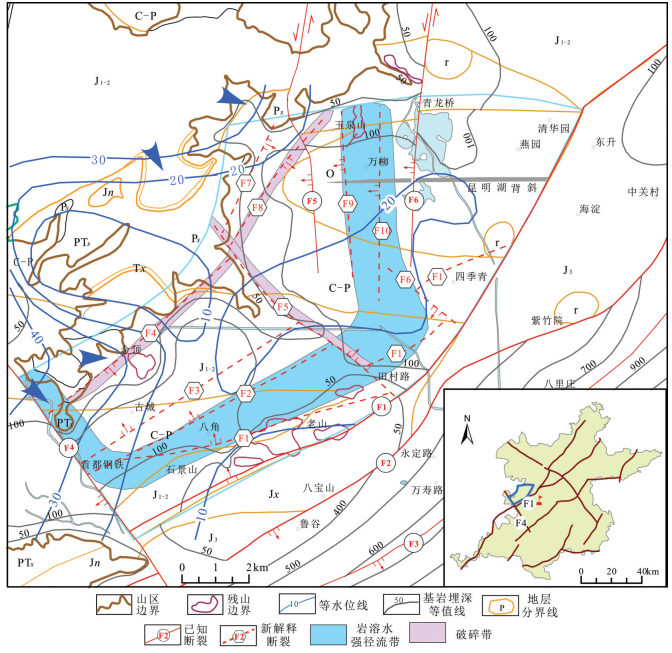
根据以上解释推断成果,结合钻孔和其他地质地球物理资料,对研究区新的地层和断裂有了新的认识。区内新解释推断的断裂皆为正断层,容易沿断裂带形成连通性较好的破碎带,进而成为潜在的径流通道。分析2015年9月西郊地下水流场分布曲线(图 6中蓝色等值线),可得出研究区地下水主要径流方向(图 6中蓝色箭头所示)。其中一个可能存在的地下水径流方向为永定河断裂附近向东,经过本次综合解释推断,该部位存在3条走向北东向的正断裂F1、F2和F3,且正断层的下降盘通常裂隙发育,易形成富水区,故F1和F2的下降盘,即两者之间的区域可能存在强径流带。另外,沿F5断裂东北部存在一近乎平行F5断裂走向的地下水径流方向,故本次沿F5断裂下降盘圈定为可能成为导水通道的破碎带。沿F4和F8山前断裂带因裂隙发育也可能成为潜在导水的破碎带。
5. 讨论
(1) 研究区及周边地质结构复杂,区域上发育有九龙山—香峪—大梁向斜和红庙岭—八大处背斜,本次研究区东边界为八宝山断裂,南边界为永定河,西边界为玉泉山北界。在强烈褶皱过程中,柔性地层以厚度和产状变化形式释放应力,而脆性岩石则以X节理和断裂的方式体现(唐春雷等, 2015; Qin et al., 2017),故研究区有发育断裂构造、形成强径流带的地质基础。此外,通过本次综合地球物理勘查,新解释推断了10条断裂,与部分钻孔揭露情况吻合。其中:①F5断裂位于研究区中部,为正断层,走向NW,倾向NE,在剩余重力异常图上表现为等值线密集,断裂东北侧整体重力异常值较低,西南侧整体重力值较高,边缘检测Theta图上为明显的北西向条带状高值异常。通过计算0.5、1.0、5.0及10.0 km上延重力异常,联合分析发现F5断裂在深部有向北东方向偏转的趋势。同时,研究区搜集的钻孔资料显示,沿F5断裂附近,西南侧覆盖层厚度为35~40 m,东北侧则突然变为100~250 m,综合推断F5为可靠断裂;②F6断裂与F5断裂近似平行,走向NW,剩余重力异常图上等值线发生扭曲,东北侧重力异常值较西南侧高,推断为较可靠断裂;③F1、F4、F7和F8四条断裂均为走向NE的山前断裂,在剩余重力异常图上表现为等值线密集,边缘检测Theta图上表现为局部不连续的条带状高值异常。且F8断裂在CSAMT反演视电阻率等值线断面上对应位置表现为视电阻率曲线呈密集陡降带,两侧视电阻率值变化较为明显。故F1、F4、F7和F8综合推断为较可靠断裂;④F2和F3断裂位于研究区西南部,走向NE,剩余重力上表现为等值线密集带,边缘检测Theta图上表现为局部不连续的条带状高值异常。秦大军等(2019)通过分析研究区水化学及地下水补给特征,认为研究区西南侧可能存在一条北东向地下水径流路径,与本次解释推断的F2、F3断裂走向和产状大体一致,故综合推断F2和F3为较可靠断裂;⑤F9和F10断裂位于研究区东北部,走向近SN,与已知冷泉村断裂近似平行,在剩余重力异常图上表现为等值线密集,边缘检测Theta图上表现为局部不连续的条带状高值异常。且在CSAMT反演视电阻率等值线断面上对应位置表现为视电阻率曲线呈密集陡降带,两侧视电阻率值变化较为明显,综合推断为较可靠断裂。
(2) 本次通过大比例尺面积性重力测量,在研究区普安店—贾家坟—黑塔村一带发现一处显著的低重力、低电阻率及低速异常带。根据重力反演结果显示,该处低密度地层石炭—二叠系(平均密度石炭系2.52 g/cm3、二叠系2.68 g/cm3)厚度异常增大,符合该异常带位于九龙山向斜内部褶皱转折部位的地层发育规律。此外,该异常带还可能与奥陶系灰岩地层裂隙发育富水程度高有关,也不排除深部发育低密度隐伏岩体的可能。
(3) 现有水文地质研究认为,位于九龙山—香峪向斜西北翼的清水涧—军庄裸露奥陶系灰岩区的补给,以及永定河在此段的河道渗漏补给,是形成玉泉山泉水的主要来源。且因军庄地区灰岩地下水位比玉泉山泉水位高约50 m,推断岩溶水是通过九龙山—香峪向斜经深部径流的形式补给玉泉山泉及平原地区地下水(杨平等, 1984; 王晓红等, 2011; 秦大军等, 2019)。唐春雷等(唐春雷等, 2015)通过分析岩溶水流场、水温等水化学特征以及岩溶发育机理相关的单井涌水量统计结果,不支持军庄岩溶水过九龙山向斜下部岩溶含水层径流补给玉泉山岩溶水的观点,并同时提出军庄岩溶水通过永定河松散覆盖层越过九龙山向斜,沿八大处背斜轴部一带的断裂破碎带二次导入下伏灰岩含水层。王莉蛟等认为,香峪向斜具有阻水特性,而永定河断裂导水性极强,鲁家滩地区接受补给后,沿八宝山断裂向东北方向流动,军庄地区接受补给后则沿永定河断裂向八宝山断裂汇集,并沿八宝山断裂向玉泉山地区排泄(杨平等, 1984; 王莉蛟等, 2016)。秦大军等通过水化学和地下水补给综合分析方法,认为八宝山北侧存在一条北东向径流通道(Qin et al., 2017; 秦大军等, 2019)。通过分析研究区2015年9月西郊地下水流场分布曲线,得出研究区地下水主要径流方向有4个:沿永定河断裂(SSE)方向;从永定河沿F1断裂(SE)方向;从山区进入平原区,沿F5断裂(SE)方向;从山区向东直接补给玉泉山。根据以上分析,结合本次地球物理勘查成果,综合判断沿F1和F2断裂的下降盘存在一条地下水强径流带,F5断裂下降盘圈定为可能成为导水通道的破碎带,沿F4和F8山前断裂带因裂隙发育也可能成为潜在导水的破碎带。
6. 结论
(1) 除已知永定河断裂、八宝山断裂和冷泉村断裂外,通过本次综合地球物理分析,新解释推断了10条可能存在的断裂。断裂性质皆为正断层,走向以北东向(6条)为主,同时发育近南北向(2条)和北西向(2条)断裂。
(2) 基于综合地球物理成果,结合区域已有钻探和水工环资料,对研究区断裂的水文地质意义进行了分析,推断沿北西向断裂附近可能存在一条岩溶水强径流带,另外存在两条潜在导水的破碎带,形成了玉泉山地区岩溶水强径流路径新认识。
(3) 探索了利用综合地球物理勘查技术分析岩溶水径流路径的工作思路和方法,对类似工作的开展具有很好的借鉴意义。
-
图 3 AA'剖面综合分析图(平面位置见图 2a)
a—正演计算布格重力异常(红线)与实际测量布格重力异常(蓝线)对比关系;b—重力反演解释推断的地质剖面(D为重力反演得到的地层密度,单位:g/cm3)
Figure 3. Comprehensive analysis diagram of AA' section
a-Bouguer gravity anomaly comparison chart between data calculated by forward modelling (red line) and actually surveyed (blue line); b-Geological profile inferred by gravity inversion results (D is density calculated by gravity inversion, Unit: g/cm3)
图 4 BB'剖面综合分析图(平面位置见图 2a)
a—基于 Kriging插值得到的微动测深视 S波速度剖面;b—CSAMT反演视电阻率等值线断面图;c—正演计算布格重力异常(红线)与实际测量布格重力异常(蓝线)对比关系;d—基于重力反演模型综合解释推断的地质剖面(D为重力反演得到的地层密度,单位:g/cm3)
Figure 4. Comprehensive analysis diagram of BB'section
a-S-wave apparent velocity profile obtained by interpolating microtremor survey data; b-Apparent resistivity section from CSAMT inversion data; c-Bouguer gravity anomaly comparison chart between data calculated by forward modelling (red line) and actually surveyed (blue line); d-Geological profile inferred by gravity inversion results (D is density calculated by gravity inversion, Unit: g/cm3)
图 5 微动测深数据综合分析图
a—红色圆点为实测频散数据,蓝线为反演最终模型计算得到的频散曲线;b—反演得到的S波速度结构曲线和地质解释推断柱状图
Figure 5. Comprehensive analysis diagram of micorotremors data
a-Red dots are dispersion data calculated from actual surveyed data, blue line is dispersion curve calculated from forward model; b-S-wave apparent velocity profile obtained by microtremor inversion and geological histogram inferred by microtremor inversion data
表 1 研究区地层物性特征统计
Table 1 Statistics of petrophysical properties of strata in the study area

-
Aki K.1957.Space and Time Spectra of Stationary Stochastic Waves, with Special Reference to Microtremors[J].Bulletin, Earthquake Research Institute, (35):415-456. http://cn.bing.com/academic/profile?id=a123eb4887c7f8163129777721d48cbd&encoded=0&v=paper_preview&mkt=zh-cn
Capon J.2005.High-resolution frequency-wavenumber spectrum analysis[J].Proceedings of the IEEE, 57(8):1408-1418. http://d.old.wanfangdata.com.cn/NSTLQK/NSTL_QKJJ0215309264/
Cheng Dongxing, Li Yanqing, Xu Zhongping, Zhang Zehong.2011.Introduction of gravity data processing and interpretation[J].WestChina Exploration Engineering, 2(6):15-19(in Chinese). http://downloads.hindawi.com/journals/ijgp/2011/927080.pdf
Cao Chuanghua, Liu Jianxin, Tong Xiaozhong, Xiewei, Tong Gangtie, Gao Dawei.2013.Discussion and application of CSAMT method with progressively inversion technology[J].The Chinese Journal of Nonferrous Metals, 23(9):2340-2350(in Chinese with English abstract). http://cn.bing.com/academic/profile?id=6511bd78d577d2d5d85e56325a19f631&encoded=0&v=paper_preview&mkt=zh-cn
Cai Yuemei, Wang Wenxiang, Zhang Mingjiang, Yin Xiulan, Cai Wutian, Wang Ruijiu, Li Wenpeng.2016.An analysis of the groundwater flow system based on environmental isotopes in Turpan basin[J].Geology in China, 43(4):1439-1445(in Chinese with English abstract). http://cn.bing.com/academic/profile?id=746cddda6d23e4eca39a9761625f3a9b&encoded=0&v=paper_preview&mkt=zh-cn
Dong Jian, Chen Lei, Zhang Guili.2018.Characteristics of geophysical fields around gold deposits in the Xiadian region, Shandong Province[J].Geology and Exploration, 54(1):138-147(in Chinese with English abstract). http://en.cnki.com.cn/Article_en/CJFDTotal-DZKT201801015.htm
Feng Juan, Meng Xiaohong, Chen Zhaoxi, Zhang Sheng.2014.Review of the gravity density interface inversion[J].Progress in Geophysics, 29(1):223-228(in Chinese with English abstract). http://cn.bing.com/academic/profile?id=38bcb4563390b7772868d4f7e1d1dbd4&encoded=0&v=paper_preview&mkt=zh-cn
Liang Yongping, Zhao Chunhong, Tang Chunlei, Wang Weitai, Shen Haoyong.2015.Progress of hydrogeology and environmental geology survey in karst area of northern China:An example from western hills of Beijing[J].Geological Survey of China, 29(1):223-228(in Chinese with English abstract). http://en.cnki.com.cn/Article_en/CJFDTOTAL-DZDC201508001.htm
Li Jinghe, He Zhanxiang, Xiong Bin.2018.Fast 2D forward modeling and inversion of CSEM with topography in the frequency domain[J].Geology and Exploration, 54(2):325-331(in Chinese with English abstract). http://d.old.wanfangdata.com.cn/Periodical/dzykt201802010
Ma Zhiyuan, Niu Guangliang, Liu Fang, Hou Guangcai, Dang Xueya, Su Yan.2006.Isotope evidence of strong runoff zones of karst groundwater in eastern Weibei, Shaanxi, China, and its renewability evaluation[J].Geological Bulletin of China, 25(6):756-761(in Chinese with English abstract).
Qin D J, Zhao Z F, Guo Y, Liu W C.2017.Using hydrochemical, stable isotope, and river water recharge data to identify groundwater flow paths in a deeply buried karst system[J].Hydrological Processes, 31:4297-4314. doi: 10.1002/hyp.11356
Qin Dajun, Sun Jie, Guo Yi, Li Lu, Mohammed Haji, Wang Dongdong, Liu Wencai.2019.Impacts of yongding river on the Xishan karst aquifer and Yuquan spring in Beijing, China[J].Journal of Engineering Geology, 25(6):756-761(in Chinese with English abstract).
Ran Weiyan, Wang Zhendong.1994.Then long-wave microtremors method and its advances[J].Geophysical and Geochemical Exploration, 18(1):28-34(in Chinese with English abstract). http://en.cnki.com.cn/Article_en/CJFDTOTAL-WTYH401.007.htm
Satoh T, Kawase H, Matsushima S.2001.Estimation of S-Wave velocity structures in and around the Sendai Basin, Japan, using array records of microtremors[J].Bulletin of the Seismological Society of America, 91(2):206-218. doi: 10.1785/0119990148
Sun Linhua, Gui Herong, Chen Song.2009.Use of geochemical inversion to study deep groundwater pattern in northern Anhui mining areas[J].Coal Geology of China, 21(1):35-38(in Chinese with English abstract). http://en.cnki.com.cn/Article_en/CJFDTotal-ZGMT200901011.htm
Sun Houyun, Mao Qigui, Wei Xiaofeng, Zhang Huiqiong, Xi Yeze.2018.Hydrogeochemical characteristics and formation evolutionary mechanism of the groundwater system in the Hami basin[J].Geology in China, 45(6):1128-1141(in Chinese with English abstract). http://en.cnki.com.cn/Article_en/CJFDTotal-DIZI201806005.htm
Tan Handong, Jiang Mei, Lin Changhong, Peng Miao, Wu Liangshi, Ma Huan, Wang Zhongkai, Li Jinjin, Tan Jiayan.2013.Characteristics of electrical structure of Tengchong volcanotectonic belt in Yunnan province[J].Geology in China, 40(3):800-805(in Chinese with English abstract). http://d.wanfangdata.com.cn/Periodical/zgdizhi201303012
Tang Jingtian, Zhou Cong, Deng Xiaohong.2010.Identification and discrimination of the horizontal layered earth by usiong CSAMT apparent resistivity curves[J].Geology and Exploration, 46(6):1079-1086(in Chinese with English abstract).
Tang Chunlei, Liang Yongping, Ji Tiequn, Wang Weitai, Zhao Chunhong, Shen Haoyong.2015.Hydrogeological significance of the Jiulongshan-Xiangyu syncline at Yuquanshan spring[J].Carsologica Sinica, 34(5):431-437(in Chinese with English abstract). http://en.cnki.com.cn/Article_en/CJFDTotal-ZGYR201505002.htm
Wang Qiang, Mou Huirong, Liu Taifu.1998.A primary study on the genesis and features of karst from Ordovician system in the Xishan hill of Beijing[J].Beijing Geology, (3):1-9(in Chinese with English abstract). http://en.cnki.com.cn/Article_en/CJFDTOTAL-JBDZ803.000.htm
Wang Ruo, Wang Miaoyue.2003.Inversion method of controlled source audio-frequency magnetotelluric data[J].Progress in Geophysics, 18(2):197-202(in Chinese with English abstract). http://en.cnki.com.cn/Article_en/CJFDTotal-DQWJ200302003.htm
Wu Qianqian, Ren Jiaguo, Xu Mo.2008.Isotope features and supply sources of groundwater in the Yarkant river drainage area, Xinjiang[J].Geology in China, 35(2):331-336 (in Chinese with English abstract). http://d.wanfangdata.com.cn/Periodical/zgdizhi200802018
Wang Xiaohong, Liu Wencheng, Shen Yuanyuan, Liu Shicheng.2011.Analysis on the hydrogeology characteristics and exploitation potential of the emergency karst water source field in Xishan region, Beijing[J].Carsologica Sinica, 30(2):216-221(in Chinese with English abstract). http://en.cnki.com.cn/Article_en/CJFDTOTAL-ZGYR201102021.htm
Wang Lijiao, Zhang Youquan, Gong Huili, Yang Guoqing, Liu Jiurong, Sun Ying.2016.A study on recovery condition of Yuquanshan spring in Beijing[J].Hydrogeology and Engineering Geology, 43(3):22-28 (in Chinese with English abstract). http://d.old.wanfangdata.com.cn/Periodical/swdzgcdz201603005
Wu Luping, Shi Kunfa, Li Yinhuai, Li Songhao.1996.Application of CSAMT to the search for groundwater[J].Acta Geophysica Sinica, 43(3):22-28 (in Chinese with English abstract). http://en.cnki.com.cn/Article_en/CJFDTOTAL-DQWX605.014.htm
Wu Le, Zhang Youquan, Gong Huili, Ye Chao, Shen Yuanyuan, Wang Rong.2016.Numerical simulation of groundwater flow for Xishan area in Beijing[J].Hydrogeology and Engineering Geology, 43(3):29-36 (in Chinese with English abstract). http://www.en.cnki.com.cn/Article_en/CJFDTotal-SWDG201603006.htm
Xu Guanghui, Huang Lijun, Liu Ruide.2005.The application of controllable source audio frequency magetotelluric sounding to hydrogeological exploration in Beijing[J].Geophsical and Geochemical Exploration, 43(3):29-36 (in Chinese with English abstract). http://cn.bing.com/academic/profile?id=95c7a482199ef8eee35517051d7af76d&encoded=0&v=paper_preview&mkt=zh-cn
Xu Peifen, Li Chuanjin, Ling Suqun, Zhang Yinbin, Hou Chao, Sun Yongjun.2009.Mapping collapsed colums in coal mines utilizing Microtremor survey methods[J].Chinese Journal of Geophysics, 52(7):29-36 (in Chinese with English abstract). http://en.cnki.com.cn/Article_en/CJFDTOTAL-DQWX200907029.htm
Yang Ping, Hou Jingyan, Gao Ruihua.1984.The supply source of Yuquanshan spring-runoff characteristics of Ordovician karst water in front of Xishan region, Beijing[J].Hydrogeology and Engineering Geology, 2(6):15-19(in Chinese).
Yan Jiayong, Lv Qingtian, Chen Mingchun, Deng Zhen, Qi Guang, Zhang Kun, Liu Zhendong, Liu Yan.2015.Identification and extraction of geological structure information based on multi-acale edgy detection of gravity and magnetic fields:An example of the Tongling ore concentration area[J].Chinese Journal of Geophysics, 58(12):4450-4464(in Chinese with English abstract).
Zhu Liming, Wang Shuiqiang, Lei Wenmin.2012.Boundary detection of magnetic field source based on Canny theory[J].Chinese Journal of Engineering Geophysics, 9(1):44-48(in Chinese with English abstract). http://en.cnki.com.cn/Article_en/CJFDTOTAL-GCDQ201201010.htm
Zhang Baolong, Li Zhiwei, Bao Feng, Deng Yang, You Qingyu, Zhang Senqi.2016.Shallow shear-wave velocity structures under the Weishan volcanic cone in Wudalianchi volcano field by microtremor survey[J].Chinese Journal of Geophysics, 59(10):3662-3673(in Chinese with English abstract).
Zhao Chunhong, Liang Yongping, Wang Weitai, Tang Chunlei, Shen Haoyong.2017.Discussion on the characteristics of karst water systems in the Xishan area of Beijing[J].Carsologica Sinica, 36(5):641-647(in Chinese with English abstract). http://en.cnki.com.cn/Article_en/CJFDTOTAL-ZGYR201705006.htm
程东兴, 李延清, 徐忠平, 张泽红.2011.重力资料数据处理及解释概论[J].西部探矿工程, 23(12):144-146. doi: 10.3969/j.issn.1004-5716.2011.12.051 曹创华, 柳建新, 童孝忠, 谢维, 佟钢铁, 高大维.2013.CSAMT逐级反演技术的讨论及应用[J].中国有色金属学报, 23(9):2340-2350. http://d.old.wanfangdata.com.cn/Periodical/zgysjsxb201309002 蔡月梅, 王文祥, 张明江, 殷秀兰, 蔡五田, 王瑞久, 李文鹏.2016.基于环境同位素分析吐鲁番盆地地下水流系统[J].中国地质, 43(4):1439-1445. http://geochina.cgs.gov.cn/geochina/ch/reader/view_abstract.aspx?file_no=20160427&flag=1 董健, 陈磊, 张贵丽.2018.山东夏甸地区金矿床地球物理场特征[J].地质与勘探, 54(1):138-147. doi: 10.3969/j.issn.0495-5331.2018.01.015 冯娟, 孟小红, 陈召曦, 张盛.2014.重力密度界面反演方法研究进展[J].地球物理学进展, 29(1):223-228. http://d.old.wanfangdata.com.cn/Periodical/dqwlxjz201401031 梁永平, 赵春红, 唐春雷, 王维泰, 申豪勇.2015.北方岩溶区水文地质环境地质调查进展——以北京西山岩溶区为例[J].中国地质调查, 2(8):1-8. http://www.cnki.com.cn/Article/CJFDTotal-DZDC201508001.htm 李静和, 何展翔, 熊彬.2018.起伏地形频率域可控源电磁二维快速正反演[J].地质与勘探, 54(2):325-331. doi: 10.3969/j.issn.0495-5331.2018.02.010 马致远, 牛光亮, 刘方, 侯光才, 党学亚, 苏艳.2006.陕西渭北东部岩溶地下水强径流带的环境同位素证据及其可更新性评价[J].地质通报, 25(6):756-761. doi: 10.3969/j.issn.1671-2552.2006.06.017 秦大军, 孙杰, 郭艺, 李露, Mohammed Haji, 王东东, 刘文才.2019.永定河对北京西山岩溶水和玉泉山泉的影响[J].工程地质学报, 27(1):162-169. http://www.gcdz.org/CN/abstract/abstract22956.shtml 冉伟彦, 王振东.1994.长波微动法及其新进展[J].物探与化探, 18(1):28-34. http://www.cnki.com.cn/Article/CJFDTOTAL-WTYH401.007.htm 孙林华, 桂和荣, 陈松.2009.皖北矿区深层地下水径流规律的地球化学反演[J].中国煤炭地质, 21(1):35-38. doi: 10.3969/j.issn.1674-1803.2009.01.010 孙厚云, 毛启贵, 卫晓锋, 张会琼, 葸玉泽.2018.哈密盆地地下水系统水化学特征及形成演化[J].中国地质, 45(6):1128-1141. http://geochina.cgs.gov.cn/geochina/ch/reader/view_abstract.aspx?file_no=20180604&flag=1 谭捍东, 姜枚, 林昌洪, 彭淼, 吴良士, 马欢, 王忠凯, 李晋津, 谭嘉言.2013.云南腾冲火山构造区的电性结构特征及其地质意义[J].中国地质, 40(3):800-805. doi: 10.3969/j.issn.1000-3657.2013.03.012 汤井田, 周聪, 邓晓红.2010.CSAMT视电阻率曲线对水平层状大地的识别与分辨[J].地质与勘探, 46(6):1079-1086 http://d.old.wanfangdata.com.cn/Periodical/dzykt201006013 唐春雷, 梁永平, 韩凯, 纪铁群, 王维泰, 赵春红, 申豪勇.2015.玉泉山泉九龙山-香峪向斜的水文地质意义[J].中国岩溶, 34(5):431-437. http://d.old.wanfangdata.com.cn/Periodical/zgyr201505002 王强, 牟慧蓉, 刘太富.1998.北京西山奥陶系岩溶发育特征及成因初探[J].北京地质, (3):1-9. http://www.cnki.com.cn/Article/CJFDTOTAL-JBDZ803.000.htm 王若, 王妙月.2003.可控源音频大地电磁数据的反演方法[J].地球物理学进展, 18(2):197-202. doi: 10.3969/j.issn.1004-2903.2003.02.004 武倩倩, 任加国, 许模.2008.新疆叶尔羌河流域地下水同位素特征及其补给来源分析[J].中国地质, 35(2):331-336. doi: 10.3969/j.issn.1000-3657.2008.02.018 王晓红, 刘文臣, 沈媛媛, 刘士成.2011.北京西山岩溶水应急水源地水文地质特征及开采潜力分析[J].中国岩溶, 30(2):216-221. doi: 10.3969/j.issn.1001-4810.2011.02.015 王莉蛟, 张有全, 宫辉力, 杨国庆, 刘久荣, 孙颖.2016.北京市玉泉山泉恢复条件研究[J].水文地质工程地质, 43(3):22-28. http://d.old.wanfangdata.com.cn/Periodical/swdzgcdz201603005 吴璐苹, 石昆法, 李荫槐, 李松浩.1996.可控源音频大地电磁法在地下水勘查中的应用研究[J].地球物理学报, 39(5):712-717. doi: 10.3321/j.issn:0001-5733.1996.05.015 吴乐, 张有全, 宫辉力, 叶超, 沈媛媛, 王荣.2016.北京市西山地区地下水数值模拟及预测[J].水文地质工程地质, 43(3):29-36. http://d.old.wanfangdata.com.cn/Periodical/swdzgcdz201603006 徐光辉, 黄力军, 刘瑞德.2005.应用可控源音频大地电磁测深于北京水文地质勘查[J].物探与化探, 29(6):523-525. doi: 10.3969/j.issn.1000-8918.2005.06.012 徐佩芬, 李传金, 凌甦群, 张胤彬, 侯超, 孙勇军.2009.利用微动勘察方法探测煤矿陷落柱[J].地球物理学报, 52(7):1923-1930. doi: 10.3969/j.issn.0001-5733.2009.07.028 杨平, 候井岩, 高润华.1984.论北京玉泉山泉补给源——北京西山山前奥陶系岩溶水径流特征[J].水文地质工程地质, 2(6):15-19. http://www.cnki.com.cn/Article/CJFDTotal-SWDG198402005.htm 严加永, 吕庆田, 陈明春, 邓震, 祁光, 张昆, 刘振东, 汪杰, 刘彦.2015.基于重磁场多尺度边缘检测的地质构造信息识别与提取——以铜陵矿集区为例[J].地球物理学报, 58(12):4450-4464. doi: 10.6038/cjg20151210 朱黎明, 王水强, 雷文敏.2012.基于Canny理论的磁场源边界检测[J].工程地球物理学报, 9(1):44-48. doi: 10.3969/j.issn.1672-7940.2012.01.010 张宝龙, 李志伟, 包丰, 邓阳, 游庆瑜, 张森琦.2016.基于微动方法研究五大连池火山区尾山火山锥浅层剪切波速度结构[J].地球物理学报, 59(10):3662-3673. doi: 10.6038/cjg20161013 赵春红, 梁永平, 王维泰, 唐春雷, 申豪勇.2017.北京西山泉域岩溶水系统特征探讨[J].中国岩溶, 36(5):641-647. http://d.old.wanfangdata.com.cn/Periodical/zgyr201705006 -
期刊类型引用(13)
1. 陈玲玉,解建建,刘恋. ERT在晋祠泉复流工程地下水勘查中的应用. 工程地球物理学报. 2024(04): 621-627 .  百度学术
百度学术
2. 郭高轩,代垠东,许亮,朱琳,戚琦,欧志亮,沈媛媛. 北京市岩溶地下水质量评价及其生态环境效应. 中国地质. 2024(04): 1266-1279 .  本站查看
本站查看
3. 吕红霞,张淼,王东水,刘心远,晋雪松,王思思,王超. 永定河北京段生态补水回顾与思考. 北京水务. 2024(04): 40-46 .  百度学术
百度学术
4. 黎光和,潘兴瑶,李炳华,杨勇,杨默远,张东,欧阳友. 永定河北京段秋季生态补水对玉泉山泉的补给效果探究. 水文. 2023(01): 30-34 .  百度学术
百度学术
5. 李巧灵,雷晓东,朱琳,李晨,陈蓓蓓. 基于微动探测地下空间异常响应特征研究. 工程勘察. 2022(01): 70-78 .  百度学术
百度学术
6. 李巧灵,张辉,雷晓东,李晨,房浩,关伟,韩宇达,赵旭辰. 综合利用多道瞬态面波和微动探测分析斜坡内部结构. 物探与化探. 2022(01): 258-267 .  百度学术
百度学术
7. 黄理善,侯一俊,陈远荣,敬荣中,王建超,赵毅,李学彪,裴超,曾友强,曾晖. 基于物探-化探技术快速精确定位评价城市及周边隐伏断层——以广西桂林市临桂区为例. 中国地质. 2022(03): 929-942 .  本站查看
本站查看
8. 杨先杰,毛承英,黄霖,何廷全,周延洁. 微动探测技术在蠕动变形斜坡勘察中的应用. 公路工程. 2022(05): 86-93 .  百度学术
百度学术
9. 姜国庆,尚通晓,黄敬军,徐士银,章其华,武鑫,顾勤平. 基于综合地球物理方法的覆盖型岩溶发育规律研究——以徐州地区为例. 地球物理学进展. 2022(06): 2571-2579 .  百度学术
百度学术
10. 郭淑君,朱继良,王春辉,任政委,明圆圆,李梦. 电震联合法在涪陵裂隙溶洞调查中的应用研究. CT理论与应用研究. 2021(01): 49-59 .  百度学术
百度学术
11. 沈媛媛,郭高轩,欧志亮,辛宝东,南英华,王丽亚,王树芳,刘久荣. 北京玉泉山泉恢复方案. 南水北调与水利科技(中英文). 2021(04): 645-655 .  百度学术
百度学术
12. 孙银行,田蒲源,杨勤海,杨桂新,朱庆俊. 花岗岩地区物探找水——以山东临朐地区研究为例. 矿产勘查. 2021(09): 1959-1963 .  百度学术
百度学术
13. Jian Yang,Sheng-xian Liang,Qiao Wang,Wei Zhang,Jing Guo,Guo-zhong Liao. Concealed porphyry delineation based on nonlinear three-dimensional density-difference inversion: An example in the Beiya mine area, Western Yunnan, China. China Geology. 2019(03): 342-353 .  必应学术
必应学术
其他类型引用(1)


 下载:
下载:
